Leen Helmink Antique Maps
Antique map of New France by Chatelain
The item below has been sold, but if you enter your email address we will notify you in case we have another example that is not yet listed or as soon as we receive another example.

Stock number: 18887
Zoom ImageCartographer(s)
Henri Abraham Chatelain (biography)
Title
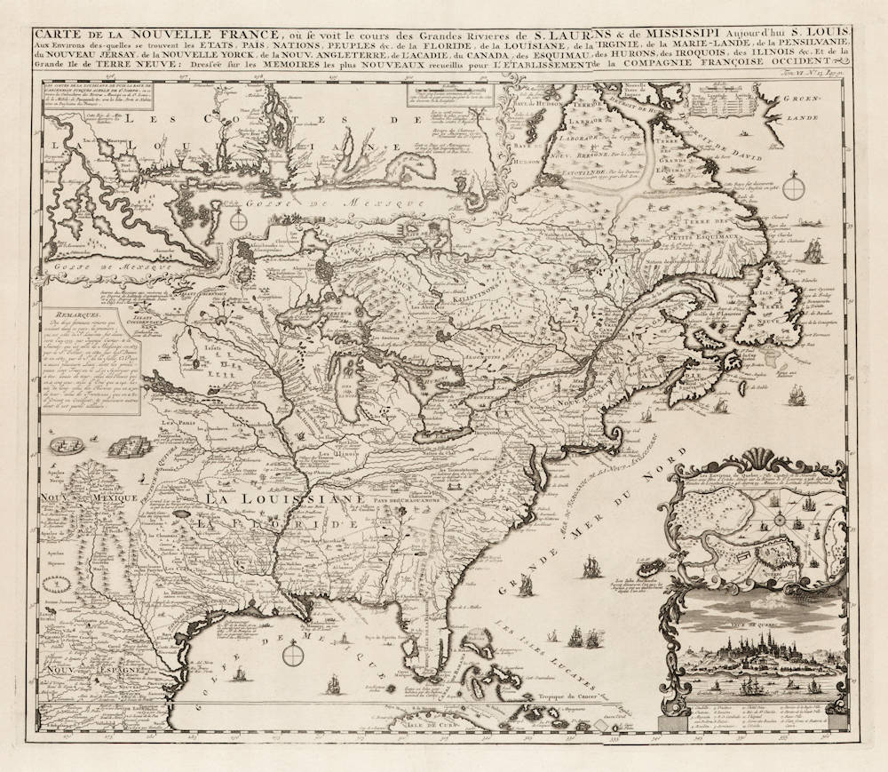
Carte de la Nouvelle France, ou se voit le cours des Grandes Rivieres de. S. Laurens & de Mississipi
First Published
Amsterdam, 1719
This Edition
1719
Size
43.0 x 50.0 cms
Technique
Condition
mint
Price
This Item is Sold
Description
Derived from de Fer's landmark 1718 map in 4 sheets, from west of the Mississippi it contains a mass of inland detail with notes and vignettes of the indigenous peoples and fauna of North America. In an inset at top left the coast of Louisiana, in another inset at bottom right a panoramic view and plan of Quebec. Louisiana and the Mississippi valley are based on Delisle's manuscript map of 1701. The geography of New England and Eastern Canada originates with Franquelin.
At the top left of the map is large scale map of the Mississippi Delta and Mobile Bay, based upon the 1699 voyage of Pierre Le Moyne d'Iberville. D'Ibeville explored the mouth of the Mississippi and its many tributaries, including the Red River in Arkansas.
The map is filled with wildlife, scenes of Indians hunting, Indian villages and notations, and the oceans are embellished with numerous ships, canoes and sea monsters.
The map was issued to promote the recently established Compagnie Francoise Occident, which was formed to fund the debt of Louix XIV and offered inducements to encourage settlement in Louisiana. From Chatelain's Atlas Historique et Méthodique.
(Joppen)
Henri Abraham Chatelain (1684-1743)
Chatelain was a Huguenot pastor of Parisian origins. He lived consecutively in Paris, St. Martins, London (c. 1710), the Hague (c. 1721) and Amsterdam (c. 1728). Chatelain was a skilled artist and knew combining a wealth of historical and geographical information with delicate engraving and an uncomplicated composition. Groundbreaking for its time, this work included studies of geography, history, ethnology, heraldry, and cosmography. His maps with his elegant engraving are a superb example from the golden age of French mapmaking.The publishing firm of Chatelain, Chatelain Frères and Chatelain & Fils is recorded in Amsterdam, from around 1700-1770, with Zacharias living "op den Dam" (Dam Square) in 1730.
Henri Abraham Chatelain, his father Zacharie Chatelain (d.1723) and his younger brother Zacharie Junior (1690-1754), worked as a partnership publishing the Atlas Historique, Ou Nouvelle Introduction à L'Histoire under several different Chatelain imprints, depending on the Chatelain family partnerships at the time of publication. The atlas was published in seven volumes between 1705 and 1720, with a second edition appearing in 1732. The volumes I-IV with a Third edition and volume I with a final edition in 1739.
Henri Abraham Chatelain, whose "Atlas Historique" was one of the most expansive Dutch encyclopedias of the age. First published in 1705, Chatelain's Atlas Historique was part of an immense seven-volume encyclopedia. Although the main focus of the text was geography, the work also included a wealth of historical, political, and genealogical information. The text was compiled by Nicholas Gueudeville and Garillon with a supplement by H.P. de Limiers and the maps were engraved by Chatelain, primarily after charts by De L'Isle. The atlas was published in Amsterdam between 1705 and 1721 and was later reissued by Zacharie Chatelain between 1732 and 1739.
(Mayers)


