Leen Helmink Antique Maps
Antique map of the World by Pierre Du Val
The item below has been sold, but if you enter your email address we will notify you in case we have another example that is not yet listed or as soon as we receive another example.

Stock number: 18854
Zoom ImageCartographer(s)
Pierre Du Val (biography)
Title
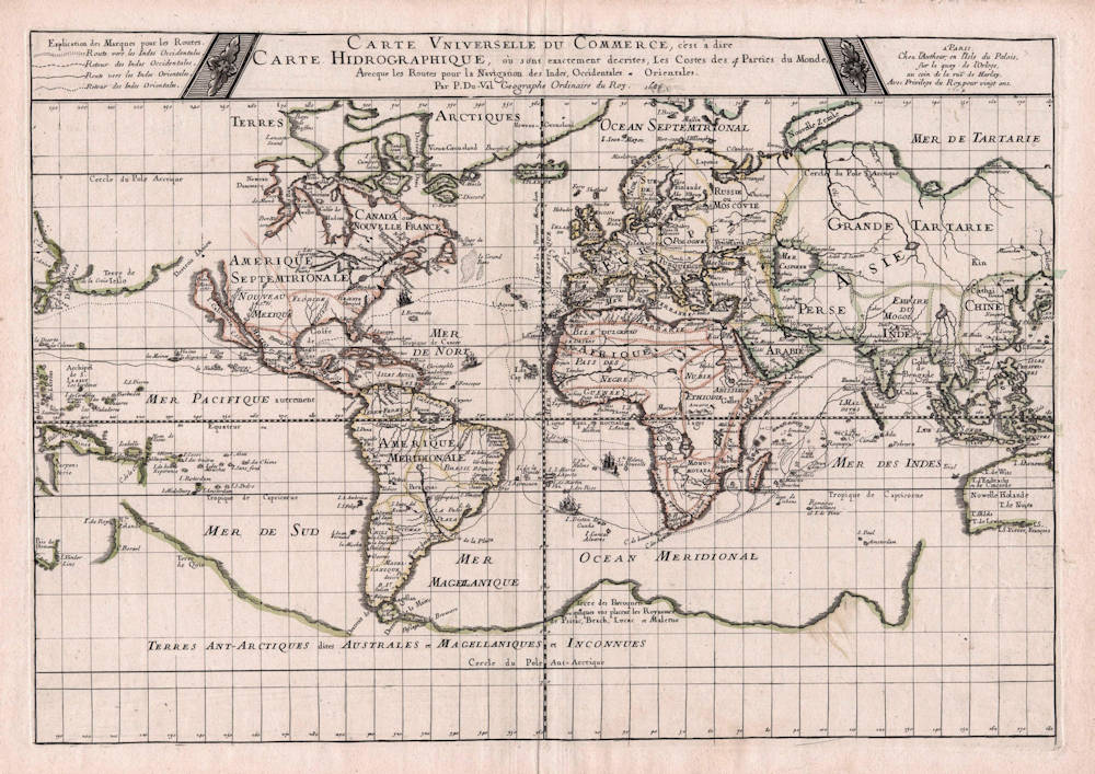
Carte Universelle Du Commerce, c'est a dire Carte Hidrographique
First Published
Paris, 1674
This Edition
1686
Size
36.5 x 53.0 cms
Technique
Condition
excellent
Price
This Item is Sold
Description
Third and final state of 1686. The map is important for showing the commercial trade routes of the day, in particular to the East and West Indies, as well as the routes of the annual Manila fleet across the Pacific from Acapulco to Manila and back, connecting the Spanish colonies of New Spain and the Philippines. The map is of special interest for the peculiar depiction of Australia.
"This plane projection of the world by Pierre du Val shows the principal trading routes across the oceans, particularly those to and from the East and West Indies.
Significantly, Du Val has shown the northern route to India and the East Indies as used by French and English ships rather than the southern route across the Indian Ocean and then northwards preferred by Dutch seamen.
Du Val's map carries minimal decoration and, as its title implies, was probably intended to be used for commercial purposes. It later appeared in Du Val's Cartes de Géographie in its second state dated 1677 in the title, and there was a third state dated 1686."
(Shirley 465).
Pierre Du Val (c.1619-1683)
Pierre Du Val was one of the most influential French mapmakers of the third quarter of the seventeenth century. He was the son-in-law and apprentice of Nicolas Sanson, the foremost French mapmaker of the period. From 1650, he was the official royal Geographer to the King of France Louis XIV, who had encouraged him to move to Paris. He published a wide range of atlases, individual maps of the world and the continents, as well as wall maps. His work was of great significance.
Related Categories
Related Items


