Leen Helmink Antique Maps
Antique map of Nagasaki Harbor with Dutch factory of Decima by Bunkindō

Stock number: 18697
Zoom ImageCartographer(s)
Bunkindō
Title
Hishū Nagasaki zu
First Published
Nagasaki, 1821
This Edition
1821
Size
61.3 x 86.7 cms
Technique
Condition
excellent
Price
$ 2,750.00
(Convert price to other currencies)
Description
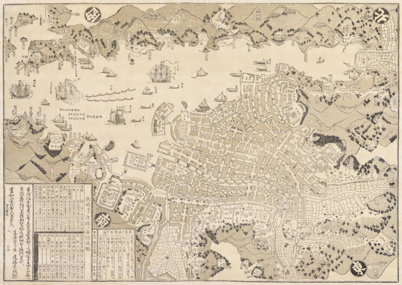
Woodcut print with original colours published in 1821 by Bunkindō, one of the four largest publishing houses for Nagasaki-e in the Edo period. Size 61,3 x 86,7 cm.
Relief shown pictorially. Oriented with north to the upper right corner. This map depicts the streets, temples, shrines, lakes and harbor of Nagasaki. In the harbor, ships from foreign countries are identified, namely ships from China and Holland. The location of the foreign colonies of Holland and China are also identified.
One written insert gives the distance between the neighboring Dukedoms and Nagasaki. It also shows the symbols for the Feudal Lords and the Stewards of the Feudal Lords.
A second written insert gives the distance between Nagasaki and several other Japanese cities. The distance are noted by land and by sea.
A third written insert is a brief preface, supplied by the publisher. The date and place of publication are found here.
The map is oriented diagonally, with straight North pointing to the upper right corner of the map. This allows an aesthetically pleasing depiction of the ships horizontally entering and exiting the port. The orientation places the Dutch factory Dejima, a fan-shaped island, in the centre of the map as its subject. Next to the Dutch factory, the map shows also the Chinese factory. At the bottom left there is a chart describing the distances from Nagasaki to various city centres. These calculations include the distances travelled by land and by sea. It states for instance, that the distance from Nagasaki to Osaka is 197 ri (Japanese miles) by land, and 235 ri by sea.
After the expulsion of the Portuguese from Japan, only Chinese and Dutch ships were allowed to come to Japan, and Nagasaki was the only harbour they were allowed to enter. Dejima became the factory ground for the Dutch East India Company (V.O.C.) in 1641. Dejima was Japan’s sole contact with Europe until the late 1850s.
The island on the map is not illustrated in great detail, but one can identify a Dutch flag and fence surrounding the perimeters of the island, and the single bridge that connects the trading post to the mainland. At this point in time, the island was made up of warehouses, and some residential housing, as illustrated by the shaded blocks and roofed houses. Life on Dejima was monotonous. The Dutch residence had to abide by strict rules, and special permission was required to leave the island.
A somewhat smaller second revised version of the map was published 40 years later, in the late 1860s, when more international traders had settled in Nagasaki.
This is so-called Nagasaki-e print, a type of print that is depicting particular characteristics of Nagasaki, is a woodblock print that became popular in the Edo period. They often depict foreigners or foreign objects, such as ships. These prints satiate the curiosity the Japanese held towards foreigners on their land, and were often bought by Japanese travellers during their stay to Nagasaki.


