Leen Helmink Antique Maps
Antique map of America by Jodocus Hondius I
The item below has been sold, but if you enter your email address we will notify you in case we have another example that is not yet listed or as soon as we receive another example.

Stock number: 18655
Zoom ImageCartographer(s)
Jodocus Hondius (biography)
Title
America
First Published
Amsterdam, 1606
This Edition
1619 French
Size
37.7 x 50.5 cms
Technique
Condition
mint
Price
This Item is Sold
Description
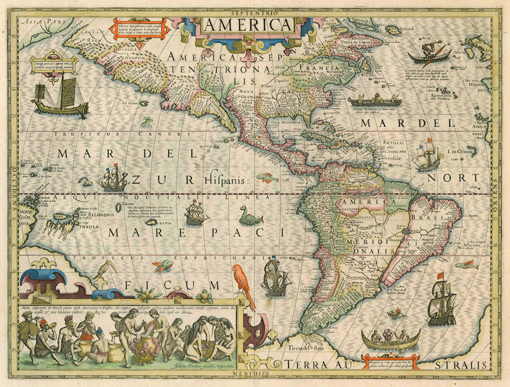
Near pristine example of one of the most decorative maps of America, by the great Jodocus Hondius the Elder. Tiny split in the lower centerfold margin, touching the outer border, but not the map area. Strong and even impression of the copperplate. Wide margins all around. Beautiful contemporary color.
The map has the latest discoveries by Francis Drake, with whom Hondius was befriended during his years in London. Drake's Golden Hind is shown crossing the Pacific, and his Nova Albion is prominently shown on the California coast. The Japanese sampan in the upper left is copied from Oliver van Noort's Journal of 1602. Van Noort had stopped one outside Manila harbor in December 1600, and was very impressed with the square reed mat sails, the wooden anchors, and the straw cordage. Van Noort's Mauritius is shown off the coast of Chile. Thomas Cavendish' Desire is depicted mid Pacific. The ship off the Caribbean appears to be Drake's Swan. It is no coincidence that Hondius chose to populate these Spanish waters with English and Dutch ships, to show the world that the treaty of Tordesillas was a dead letter. The late 1500s and early 1600s had the Dutch and English unified against their common enemy the Spain Empire, with great joint naval successes like the defeat of the Spanish Armada and the Raid of Cadiz. The Dutch and English were determined to challenge the Iberian hegemony in the Americas, in Africa and in Asia, and get access to the profitable trade in these overseas areas.
In addition to the Anglo-Dutch ships, the map depicts three vessels of the American natives. In the upper right is a Greenland Inuit hunter in a kayak, with a double-bladed paddle, armed with a harpoon for fishing, whaling or sealing. He is wearing a fur parka hood. The kayaks were made from stitched seal or other animal skins stretched over a driftwood or whalebone skeleton frame. Off the coasts of Virginia and Florida, a Floridian dugout canoe is depicted. As noted underneath it, it was made from a single log, and hollowed out by setting the inside on fire. This was surprising to Europeans, who knew no trees like that. The scene is copied from Theodor de Bry's 1590 description of the Virginia colony, who had copied the scene from John White's drawings. Two women are tending a fire in the middle of the canoe, while the men are fishing with nets and spears. In the lower right, off Magellan's Strait, is a Patagonian bark canoe.
The map is famous for the scene in the lower left showing Brazilian indians preparation and drinking of Cauim (Manioc Beer), and is also taken from de Bry. The custom was first described in detail by Jean de Léry, who had lived with the Tupinambá natives in Brazil in 1557-1558 and had published about this in his 1578 History of a Voyage to the Land of Brazil, Also Called America.
The Mapping of North America
This map was engraved by Jodocus Hondius for his first edition of Gerard Mercator's atlas. Intended to be a grand comprehensive work, with the first part originally appearing in 1585, by Mercator's death in 1594 only two parts had been published. Continued by his family, it was still incomplete for the 1602 edition, lacking most importantly a section on the Iberian peninsula. During this time it was also competing with the remarkably successful atlas of Abraham Ortelius which averaged almost obe edition per year. By 1604 Jodocus Hondius was flourishing, and in that year acquired all of the plates from Mercator's descendants. He immediately set about engraving many new maps to augment and complete the work, amongst which was a set of the four continents. He also had the original text expanded by Petrus Montanus. In the following year he brought out Mercator's Ptolemy, and in 1606 his first edition of the general atlas which proved instantly popular, selling out within a year.
Right up until 1630 this map was issued alongside the America sive India Nova by Michael Mercator, 1595. Since the text describing America was always used by the Mercator, this one is always lacking one. Produced on a stereographic projection like more and more maps of the time, it is an amalgam of various sources. It incorporates a more correct west coast of South America and narrows still further the longitudinal width of New Spain at the Tropic of Cancer, making it just 10 degrees, much closer to reality. However, just like all cartography before, it still retains an enlarged North American continent. A Plancius type depiction of Newfoundland occurs alongside a typical period representation of the east coast, with a more protruding Virginia than usual. Various scenes taken from the earlier volumes of de Bry's 'Grand Voyages' adorn the whole. Particularly notable is the native Brazilian scene illustrating the method used to make a local beverage, derived from Hans Staden's voyage as recorded by de Bry. There are various galleons, kayaks and Indian canoes along with a pair of birds perched on the inset.
(Philip Burden).
Jodocus Hondius America
The acquisition of the Mercator plates by Jodocus Hondius was cause to reissue the atlas in 1606 with a series of new maps of the four continents. The Hondius 'America' is a very attractive map with a scene appended from Theodore de Bry showing Brazilian natives making a local beverage. Since the Michael Mercator map was published in the same volume, it is clear that Hondius' effort is the more modern version with the Drake landfall noted in California and the bulge removed from the west coast of South America. The St. Lawrence River is seen as the gateway into the interior of the northern continent but without Great Lakes.
(Richard Arkway).
The cauim drinking feast
The following description, largely from Jean de Léry's account of his trip to Brazil in the 16th century applies specifically to the Tupinambá natives who lived along the coast of central Brazil. However, it is typical of other tribes throughout Brazil.
Cauim preparation (like other cooking tasks) is strictly a women's job, with no involvement from the men. Manioc roots are sliced thin, boiled until tender, and allowed to cool down. Then women and girls gather around the pot; each repeatedly takes a mouthful of manioc, chews it, and puts it into a second pot (depending on the culture). Enzymes in the saliva then convert the starch into fermentable sugars. Men firmly believe that if they were to chew the paste, the resulting beverage would not taste as good; and anyway they consider that work as inappropriate for them as spinning yarn would be for European men. The chewed root paste is put back on the fire and stirred with a wooden spoon until completely cooked. The paste is then allowed to ferment in large earthenware pots ("half as big as a Burgundy wine barrel").
The resulting beverage is opaque and dense like wine dregs and tastes like sour milk. There are light and dark varieties of cauim, and the beverage can be flavored with various fruits.
The same process is used to make a similar beverage from maize. Since both plants grow abundantly throughout the year, the natives prepare the beverage in any season, sometimes in large quantities. Cauim can be consumed quietly by one or two people, but is most commonly consumed at parties with tens or hundreds of people, often from two or more villages. According to contemporary records, thirty or more large pots of cauim could be consumed in a single party; and "neither the German, nor the Flemish, nor the soldiers, nor the Swiss — that is, none of those people in France who devote themselves to great drinking, will match the Americans in that art." Cauim was also de rigueur in solemn occasions, such as the ceremonial killing and eating of a war prisoner.
Serving the cauim at parties is also a women's task. Cauim is better consumed warm, and so the women will place the pots over a slow fire in the village's central plaza. While keeping the pot well stirred, they will serve the beverage in drinking bowls — holding up to "three Parisian quarts" each — to the dancing men, as they pass by. While men are supposed to empty their bowls in one go (and perhaps twenty bowlfuls in a single party), the women take sips more or less continuously.
A drinking party could go on for two or three days, with music, dancing, whistling, and shouting going on all the time. Sometimes the men would force themselves to throw up in order to continue drinking. Leaving the party would be considered a great shame, 'worse than schelm among Germans'. Curiously, the Tupinambá do not eat during their drinking parties, just as they do not drink at meals; and they find the European custom of mixing the two things very strange.
Jean de Léry reports that he and his companions tried to prepare "clean" cauim by grinding and cooking manioc or maize, without the chewing step; but (predictably) it did not work. Eventually they got used to the natives' drink. "To those readers who are put off by the idea of drinking what someone else has chewed," adds the traveler, "let me remind them of how our wine is made ... by the peasants who trample on the grapes with their feet, sometimes with shoes and all; things that are perhaps even less agreeable than the chewing of American women. Just as one says that wine, by fermenting, rids itself of all impurity; so we may assume that cauim purges itself too.
(Jean de Léry).
Jodocus Hondius (1563-1612)
Jodocus Hondius the Younger (son) (1594-1629)
Henricus Hondius (son) (1597-1651)
Jodocus Hondius the Elder, one of the most notable engravers of his time, is known for his work in association with many of the cartographers and publishers prominent at the end of the sixteenth and the beginning of the seventeenth century.
A native of Flanders, he grew up in Ghent, apprenticed as an instrument and globe maker and map engraver. In 1584, to escape the religious troubles sweeping the Low Countries at that time, he fled to London where he spent some years before finally settling in Amsterdam about 1593. In the London period he came into contact with the leading scientists and geographers of the day and engraved maps in The Mariner's Mirrour, the English edition of Waghenaer's Sea Atlas, as well as others with Pieter van den Keere, his brother-in-law. No doubt his temporary exile in London stood him in good stead, earning him an international reputation, for it could have been no accident that Speed chose Hondius to engrave the plates for the maps in The Theatre of the Empire of Great Britaine in the years between 1605 and 1610.
In 1604 Hondius bought the plates of Mercator's Atlas which, in spite of its excellence, had not competed successfully with the continuing demand for the Ortelius Theatrum Orbis Terrarum. To meet this competition Hondius added about 40 maps to Mercator's original number and from 1606 published enlarged editions in many languages, still under Mercator's name but with his own name as publisher. These atlases have become known as the Mercator/ Hondius series. The following year the maps were re-engraved in miniature form and issued as a pocket Atlas Minor.
After the death of Jodocus Hondius the Elder in 1612, work on the two atlases, folio and miniature, was carried on by his widow and sons, Jodocus II and Henricus, and eventually in conjunction with Jan Jansson in Amsterdam. In all, from 1606 onwards, nearly 50 editions with increasing numbers of maps with texts in the main European languages were printed.
(Moreland and Bannister)
Related Categories
Related Items


