Leen Helmink Antique Maps
Antique map of North America by Janssonius
The item below has been sold, but if you enter your email address we will notify you in case we have another example that is not yet listed or as soon as we receive another example.

Stock number: 18577
Zoom ImageCartographer(s)
Janssonius
Title
America Septentrionalis
First Published
Amsterdam, 1636
Size
46.5 x 55.0 cms
Technique
Condition
mint
Price
This Item is Sold
Description
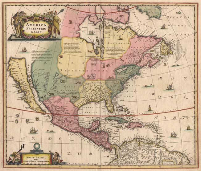
"Henricus Hondius' beautifully engraved map of North America had greater influence than any other to date in perpetuating the theory of California as an island. This was because it was disseminated through the medium of his powerful Dutch publishing house. None of the earlier California as an island maps had reached such a wide audience. The 1630s were a decade of constant development in the houses of Blaeu and Hondius. It is interesting to note that Blaeu never published a single sheet map of North America; both Willem and Joan relied upon that of the whole continent first produced in 1617, throughout their publishing history. During this decade Joannes Janssonius became an active partner of Hondius, and although this map bears no imprint it is assigned to the latter on the basis that at the same time a map of South America appeared displaying his name.
Cartographically this map is a careful composition of many different sources and illustrates well the current state of knowledge. The depiction and nomenclature of the west, along with that of the insular California, derive directly from the Henry Briggs 'The North Part of America', 1625. A legend placed strategically over the north-west coastline offers the opportunity to discontinue a coastline least understood. An unnamed lake still feeds a 'Rio del Norte' flowing incorrectly south-west into what should be the headwaters of the Gulf of California. On the east bank of this river is 'Real de Nueva Mexico', or Santa Fe. The gulf of Mexico and the Florida peninsula originate from the Hessel Gerritsz chart of c.1631.
The east coast, however, is harder to define; the south-east appears to be quite generic in form. It is the area north of here that does not appear to be from a particular source. The Chesapeake bay area is defined in about as much detail as the scale and the style of the map will allow, 'Iames Towne' being clearly identified. 'NOVUM BELGIUM' is unlike any other before it, the area between the 'Zuitt Revier' (Delaware River) and the 'Noort R' (Hudson River) being greatly elongated on a north-east to south-west axis. New Amsterdam is curiously not designated although 'Fort Orange' is present. For New England just a selectfew names have been chosen fro John Smith's map of the area, 1616. The Gulf os St. Lawrence appears to follow de Laet more than Champlain. The latter is used to depict a single great lake; however, its name. 'Lac de Iroquois', is borrowed from one nearby. Interestingly the author chose not to use Champlain's more recent 1632 map but the earlier 1612 'CARTE GEOGRAPHIQUE DE LA NOUVELLE FRANSE'. To avoid unknown territory he does not venture a river system further west, unlike Champlain. Along the Atlantic coast of Labrador we find for the first time much Dutch nomenclature, reflecting their increased whaling activities in these waters. Hudson Bay is clearly derived from Briggs, 1625, except for the west coast where he introduces the cartography of Thomas James, 1633. The addition of a fox here could be seen as a veiled reference to Luke Foxe, whose own map of the previous year bears just such an animal."
(Burden).


