Leen Helmink Antique Maps
Antique map of the North Pole by Jodocus Hondius I
The item below has been sold, but if you enter your email address we will notify you in case we have another example that is not yet listed or as soon as we receive another example.

Stock number: 17287
Zoom ImageTitle
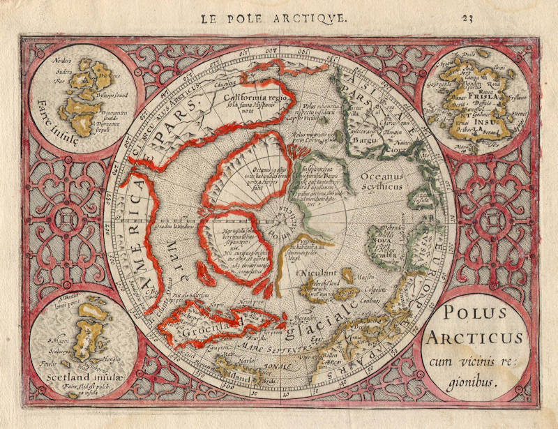
Polus Arcticus cum vicinis regionibus
First Published
Amsterdam, 1607
This Edition
1608
Size
13.5 x 18.5 cms
Technique
Condition
excellent
Price
This Item is Sold
Description
Map of the North Pole regions from the 1608 second edition of Jodocus Hondius' Atlas Minor, a reduction of the 1606 Mercator-Hondius folio map (which is a later state of the 1595 Mercator copperplate).
"Shortly after the publication of the big folio-atlases the need was apparantly felt for a smaller-sized atlas, one that would be handier, and, above all, cheaper, so that a larger public might have access to the use of maps.
The publication of the 'Atlas Minor' appeared to be a great success for Hondius; the first Latin edition was in great demand.
The copperplates of the first atlases minor were most almost certainly engraved by Jodocus Hondius himself.
After 1621, the copperplates of the 'Atlas Minor' were sold to a London editor. Firstly, they appeared in 'Purchas his Pilgrinies', printed in 1625 by William Stansby for Henry Featherstone. Next they were used for the translation of the Mercator-atlas, printed in small folio under the title 'Historia mundi, or Mercators atlas', by Thomas Cotes for Michael Sparke and Samuel Cartwight in 1635."
(Koeman).
"As with the 'Theatrum' of Abraham Ortelius, Jodocus Hondius planned a reduced size version of Gerard Mercator's folio atlas. Just one year after his first edition he published his Latin text 'Atlas Minor' in collaboration with Jan Jansz. and Cormelis Claesz. The arrangement between these three is not understood clearly but Hondius is believed to have been the owner of the copperplates. Cartographically this is taken directly from the folio maps by Hondius in 1606 [..]. with the inevitable loss of detail due to the reduction. The initial 'S' in the lower right [of the America map] probably represents the unidentified engraver."
(Burden 153).
"This map of the North Pole is a reduced verion of the revised second state of Gerard Mercator's 'SEPTENTRIONALIUM Terrarum' first issued in 1606. There are, however, a couple of noticeable differences. The map itself only extends now to just south of the Arctic Circle and the inset maps at the top of the Faeroes and Frisland have now been reversed."
(Burden 154).
Jodocus Hondius (1563-1612)
Jodocus Hondius the Younger (son) (1594-1629)
Henricus Hondius (son) (1597-1651)
Jodocus Hondius the Elder, one of the most notable engravers of his time, is known for his work in association with many of the cartographers and publishers prominent at the end of the sixteenth and the beginning of the seventeenth century.
A native of Flanders, he grew up in Ghent, apprenticed as an instrument and globe maker and map engraver. In 1584, to escape the religious troubles sweeping the Low Countries at that time, he fled to London where he spent some years before finally settling in Amsterdam about 1593. In the London period he came into contact with the leading scientists and geographers of the day and engraved maps in The Mariner's Mirrour, the English edition of Waghenaer's Sea Atlas, as well as others with Pieter van den Keere, his brother-in-law. No doubt his temporary exile in London stood him in good stead, earning him an international reputation, for it could have been no accident that Speed chose Hondius to engrave the plates for the maps in The Theatre of the Empire of Great Britaine in the years between 1605 and 1610.
In 1604 Hondius bought the plates of Mercator's Atlas which, in spite of its excellence, had not competed successfully with the continuing demand for the Ortelius Theatrum Orbis Terrarum. To meet this competition Hondius added about 40 maps to Mercator's original number and from 1606 published enlarged editions in many languages, still under Mercator's name but with his own name as publisher. These atlases have become known as the Mercator/ Hondius series. The following year the maps were re-engraved in miniature form and issued as a pocket Atlas Minor.
After the death of Jodocus Hondius the Elder in 1612, work on the two atlases, folio and miniature, was carried on by his widow and sons, Jodocus II and Henricus, and eventually in conjunction with Jan Jansson in Amsterdam. In all, from 1606 onwards, nearly 50 editions with increasing numbers of maps with texts in the main European languages were printed.
(Moreland and Bannister)
Gerard Mercator (Kremer) 1512-1594
Arnold Mercator (son) 1537–1587
Rumold Mercator (son) c. 1545– c. 1599
Bartholomeus Mercator (son) fl. 1540-1563
Gerard Mercator (grandson) c. 1563-1656
Joannes Mercator (grandson) c. 1562-1595
Michael Mercator (grandson) c. 1567–1600
For nearly sixty years, during the most important and exciting period in the story of modern map making, Gerard Mercator was the supreme cartographer, his name, second only to Ptolemy, synonymous with the form of map projection still in use today. Although not the inventor of this type of projection he was the first to apply it to navigational charts in such a form that compass bearings could be plotted on charts in straight lines, thereby providing seamen with a solution to an age-old problem of navigation at sea.
His influence transformed land surveying and his researches and calculations led him to break away from Ptolemy conception of the size and outline of the Continents, Drastically reducing the longitudinal length of Europe and Asia and altering the shape of the Old World as visualized in the early sixteenth century.
Mercator was born in Rupelmonde in Flanders and studied in Louvain under Gemma Frisius, Dutch writer, astronomer and mathematician. He established himself there as a cartographer and instrument and globe maker, and when he was twenty-five drew and engraved his first map (of Palestine) and went on to produce a map of Flanders (1540) supervising the surveying and completing the drafting and engraving himself.
The excellence of his work brought him the patronage of Charles V for whom he constructed a globe, but in spite of his favour with the Emperor he was caught up in the persecution of Lutheran protestants and charged with heresy, fortunately without serious consequences. No doubt the fear of further persecution influenced his move in 15 s 2 to Duisburg, where he continued the production of maps, globes and instruments culminating in large-scale maps Europe (1954), the British Isles (1564) and the famous World Map on 18 sheets drawn to his new projection (1969). All these early maps are exceedingly rare, some being known by only one copy.
In later life he devoted himself to his edition of the maps in Ptolemy's Geographia, reproduced in his own engraving as nearly as possible in their original form, and to the preparation of his 3-volume collection of maps to which, for the first time, the word 'Atlas' was applied. The word was chosen, he wrote, 'to honour the Titan, Atlas, King of Mauritania, a learned philosopher, mathematician and astronomer'. The first two parts of the Atlas were published in 1583 and 1589 and the third, with the first two making a complete edition, in 1595, the year after Mercator's death.
Mercator's sons and grandsons, named above, were all cartographers and made their contributions in various ways to the great atlas. Rumold, in particular, was responsible for the complete edition in 1595. After a second complete edition in 1602, the map plates were bought in 1604 by Jodocus Hondius who, with his sons, Jodocus II and Henricus, published enlarged editions which dominated the map market for the following twenty to thirty years.
(Moreland & Bannister).

