Leen Helmink Antique Maps
Antique map of North Pole by Hondius

Stock number: 19301
Zoom ImageCartographer(s)
Henricus Hondius (biography)
Title
Poli Arctici et Circumiacentium Terrarum descriptio novissima.
First Published
Amsterdam, 1636
This Edition
1639-49 French edition
Size
44 x 50 cms
Technique
Condition
excellent
Price
$ 2,250.00
(Convert price to other currencies)
Description
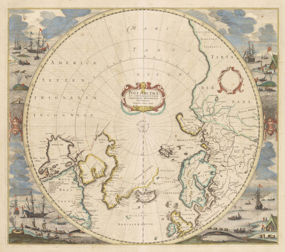
HONDIUS, Henricus. Poli Arctici et Circumiacentium Terrarum descriptio novissima. Amsterdam, between 1639-1649. Engraved map, image 440 x 492 mm (506 x 604 mm sheet). Blank cartouche, engraved whaling scenes encircle the map, French text on verso. Burden 246 State III.
The Mapping of North America
246 Henricus Hondius
POLI ARCTICI,/ ET CIRCUMIACENTIUM/ TERRARUM DESCRIPTIO/ NOVISSIMA./ Sumptibus Henrici Hondij.
From: Atlantis Novi
Amsterdam, 1636
Copperplate engraving, 440 x 500 mm.
With the many advances in knowledge of the Arctic waters in the first third of the century the Gerard Mercator map of the North Pole, 1595, had become obsolete. In recognition of the large role taken by the English in pursuit of the North West Passage, Hondius introduced a new polar map for the English edition of his atlas, 1636. This was his clear desire as the map appeared in its first two unfinished states without the surrounding decoration. By the time of the German edition in the same year the map had been completed.
Hondius drew upon the cartography of Henry Briggs, 1625, for the outline of Hudson Bay, and supplemented it with the knowledge of the west coast from Thomas James’ map, 1633. He does correctly, however, make an assumption that Baffin Island is an island. Like many other cartographers before him he is confused by the very early English voyages depicting M Forbishers Strete in Greenland. Similar to the AMERICA SEPTENTIONALIS of the same year, he incorporates a second cartouche which is left blank. Along the Atlantic coast of Labrador we find for the first time much Dutch nomenclature, reflecting their increased whaling activities in these waters. It is also interesting to note that virtually all of the earlier imaginary islands in the North Atlantic are now omitted.
This map not only appeared in its second state in the English edition of 1636, but the following English ones of 1638 and 1641 as well. As the plate was altered later in 1636, these later editions were made up of leftover stock. The first proof state appears in only two known examples of the 1636 edition. In the Latin Appendix of 1637 by Jan Janssonius, with whom he was in partnership, a new map entitled NOVA ET ACCVRATA POLI ARCTICI was issued alongside this one. Janssonius clearly had control of the market as these issues included his map. That of Hondius continued to appear in editions in German, Latin and Dutch French.
Gradually Janssonius assumed control during the 1640s and phased out the use of the Hondius plate. Curiously in these editions the map does appear in a rare fourth state with his imprint.
The plate then passed into the hands of Frederick de Wit and the map appears in an example of his atlas after having the Janssonius imprint removed. This atlas, which is in the Library of Congress (Phillips 485), is dated to 1675? It is most probably c.1676 as some of the plates were sold by Jansson van Waesberge in that year. Shortly thereafter de Wit added his own imprint to produce the sixth state which appeared in his largely undated atlases until his death. It appeared unchanged in Nicolaas Visscher atlases, and Adriaan Braakman’s Atlas Minor of 1709. Passing to Louis Renard it appeared in an altered seventh state in his Atlas de la Navigation, 1715, and again in 1739 by Reiner and Joshua Ottens. The latter’s following edition contained a new map altogether. This last state could have been carried out earlier as the spelling of de Wit’s name is changed. The plate had a long life of 103 years. States 1, 2, 4 and 5 are the rarest:
- State 1, 1636 - A ‘proof’ state in which both cartouches are blank and no scenes surround the map
- State 2, 1636 - The central cartouche bears a title and the imprint of Hondius
- State 3, 1636 - Whaling scenes now encircle the map
- State 4, pre-1664 - Hondius’ imprint replaced by Ioannis Ianssonii
- State 5, c.1676 - Janssonius’ imprint removed
- State 6, c.1676 - The imprint now reads Per Fredericum de Wit Amstelodami. The previously blank cartouche on the right now bears Gedruckt t’Amsterdam by Frederick de Wit in de Calverstraet aen den Dam inde Witte Pascaert
- State 7, 1715 - The main imprint reads PER F.DE WIT, the cartouche to the right is now blank. Outside the neatline top right appears Fol. 3. Iceland and the base of Nova Zemla have been re-engraved, and the Prime Meridian is moved 10° eastwards
The first three states appear with text on the reverse, found in the various editions of the Hondius and Janssonius atlases. States 1 and 2 are only found with English text.
References: Cumming, Skelton and Quinn (1972) fig. 276 (the uncommon third state)/ Kershaw (1993) pp. 96-7 & 99-102/ Koeman (1967) vol. 2, p. 374 no. 344, see also Braakman, Renard, Visscher and de Wit in further volumes/ Phillips (1909-) no. 485.
Locations for states 1, 2, 3, 6 and 7: National Archives of Canada, Ottawa (state 1 also)/ Harvard/ Huntington/ University of Illinois, Urbana/ JCB/ LCI/ Newberry/ Hispanic Society, New York/ NYPL/ University of Virginia, Charlottesville/ Yale/ BL, London (state 1 also)/ Bodleian Library, Oxford, England/ BN, Paris/ Maritiem Museum, 'Prins Hendrik’, Rotterdam, Netherlands (state 1)/ and others. State 4: LC (state 5 also)/ BL, London/ and others.
(Burden 246)
Rarity
The map is much rarer than its counterpart of the Antactic regions, because this one was replaced early with a different map of the North Polar regions, copied after Blaeu.
Condition description
Attractive original colour. Mild mellowing of the paper. Overall in excellent condition. A very desirable collector's copy.
Jodocus Hondius (1563-1612)
Jodocus Hondius II (son) (1594-1629)
Henricus Hondius (son) (1597-1651)
Jodocus Hondius the Elder, one of the most notable engravers of his time, is known for his work in association with many of the cartographers and publishers prominent at the end of the sixteenth and the beginning of the seventeenth century.
A native of Flanders, he grew up in Ghent, apprenticed as an instrument and globe maker and map engraver. In 1584, to escape the religious troubles sweeping the Low Countries at that time, he fled to London where he spent some years before finally settling in Amsterdam about 1593. In the London period he came into contact with the leading scientists and geographers of the day and engraved maps in The Mariner's Mirrour, the English edition of Waghenaer's Sea Atlas, as well as others with Pieter van den Keere, his brother-in-law. No doubt his temporary exile in London stood him in good stead, earning him an international reputation, for it could have been no accident that Speed chose Hondius to engrave the plates for the maps in The Theatre of the Empire of Great Britaine in the years between 1605 and 1610.
In 1604 Hondius bought the plates of Mercator's Atlas which, in spite of its excellence, had not competed successfully with the continuing demand for the Ortelius Theatrum Orbis Terrarum. To meet this competition Hondius added about 40 maps to Mercator's original number and from 1606 published enlarged editions in many languages, still under Mercator's name but with his own name as publisher. These atlases have become known as the Mercator/ Hondius series. The following year the maps were re-engraved in miniature form and issued as a pocket Atlas Minor.
After the death of Jodocus Hondius the Elder in 1612, work on the two atlases, folio and miniature, was carried on by his widow and sons, Jodocus II and Henricus, and eventually in conjunction with Jan Jansson in Amsterdam. In all, from 1606 onwards, nearly 50 editions with increasing numbers of maps with texts in the main European languages were printed.
(Moreland and Bannister)
