Leen Helmink Antique Maps
Antique map of Western Australia by Thornton

Stock number: 18994
Zoom ImageCartographer(s)
John Thornton (biography)
Title
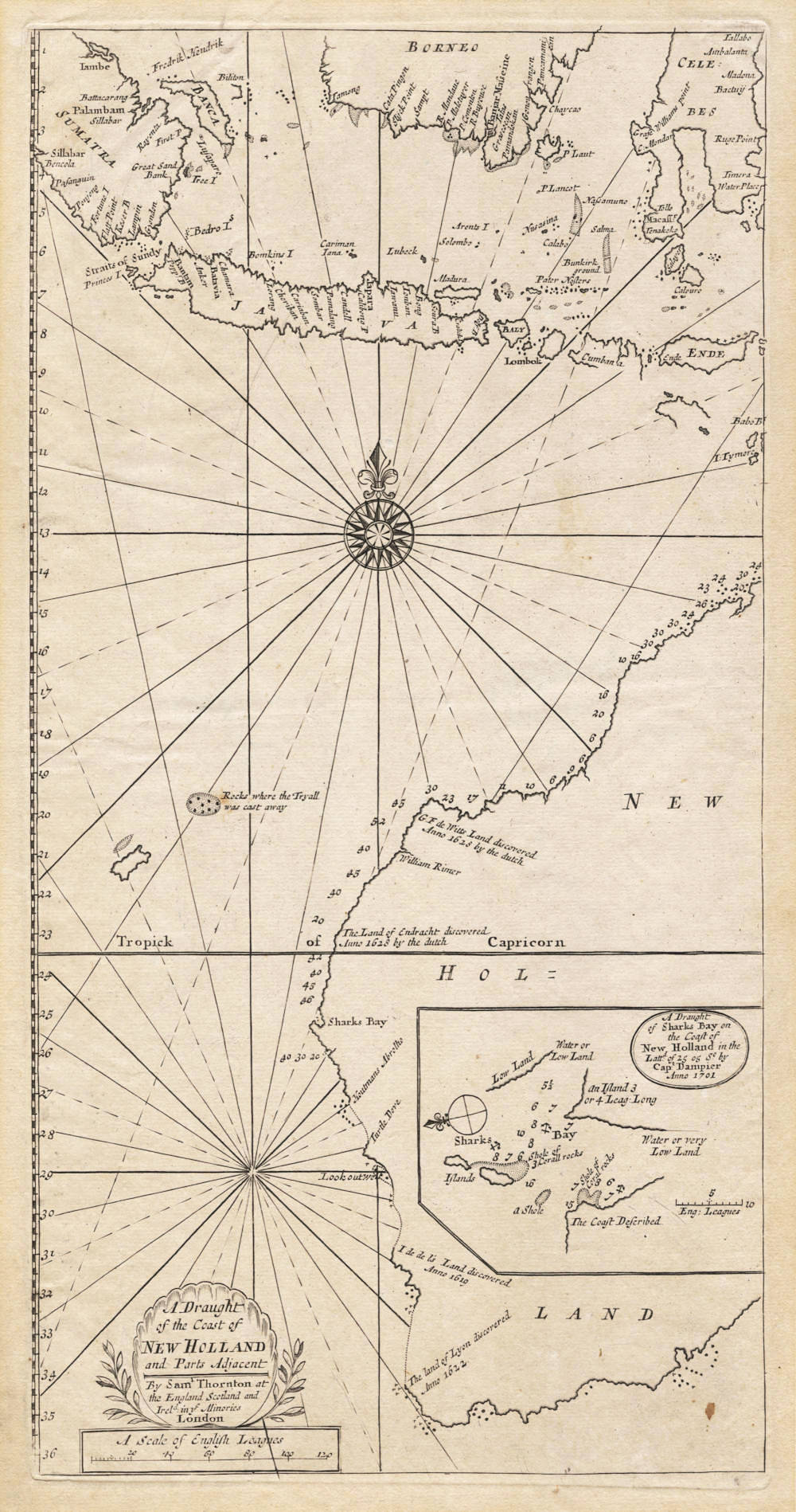
A Draught of the Coast of New Holland and Parts Adjacent
First Published
London, 1703
This Edition
1708
Size
20.0 x 39.4 cms
Technique
Condition
excellent
Price
$ 17,500.00
(Convert price to other currencies)
Description
Summary
John Thornton's beautiful map of the Western Australian coastline, published as a chart in his The English Pilot: The Third Book (1703), reproduced Dampier's survey of Shark Bay as an inset. The inclusion of Dampier's survey so quickly after the voyage may be attributed to Thornton's position as hydrographer to the English East India Company; Thornton's reputation as a successful London mapmaker and trader would have enhanced his position. A later [Mount and Page] edition of Thornton's book was included in James Cook's reference library on board the Endeavour.
(National Library of Australia)
This is the first published chart of Australia to include the discoveries at Shark Bay made by William Dampier in August 1699, and is the first published English chart devoted to the west coast of Australia. An inset map placed on the Australian continent itself details Dampier's discoveries at Shark Bay in 1699 and includes depth soundings of the immediate surrounding waters.
(Simon Dewez)
Condition
Excellent copy of this exceptionally rare and significant sea chart. Second state (of three), with the impressum of John Thornton's son Samuel, who took over the publication work after his father's death in 1708. Slight mellow discoloration of the paper caused by earlier matting. Wide margins. Two minor old restorations in the left margin, far outside the printed area. Overall a very desirable collector's copy of this extremely rare and significant sea chart.
The first published chart of Australia to include the discoveries at Shark Bay made by William Dampier in August 1699.
Thornton's rare chart is the first published English chart devoted to the west coast of Australia and the first published map of Australia to note Dampier's Shark Bay discoveries. The chart follows closely the format of Hessel Gerritsz’s 1628 map of the Malay Archipelago (Schilder map 31) and shows the southern part of Borneo, the Celebes and Sumatra in the north.
Only the western part of Australia is shown and is labelled on the chart New Holland. Thornton's chart details the first Dutch west coast discoveries by Hartog in 1616 although on the map these are given the incorrect date of 1628 (The land of Endracht discovered Anno 1628 by the dutch [sic]). The discoveries made by Houtman in 1619, the Leeuwin in 1622 and de Witt in 1628 are also noted.
An inset map placed on the Australian continent itself, details Dampier's discoveries at Shark Bay in 1699 and includes depth soundings of the immediate surrounding waters. As a result of Dampier's extensive sailing knowledge firstly as a buccaneer and later in the Pacific in the Cygnet in 1686, he received a royal commission in 1699 and set sail for the Far East in the HMS Roebuck. Dampier landed on Australia's west coast in August 1699 at Shark's Bay, which he proceeded to extensively, but not completely survey. He then sailed north where he made further surveys of the west coast of Australia. These depth soundings are noted on Thornton's map. Although the English placed great emphasis on this voyage, Dampier ultimately made no major cartographic discoveries during his voyage, although he did discover New Britain off New Guinea's north-east coast, via the strait that now bears his name.
Thornton also charts the Triall Islands off the west Australian coast. These were named after the 1622 shipwreck of the English ship the Triall. The location of these islands was often incorrectly shown on maps to be further north than they are in reality. This was because the survivors incorrectly noted their true location. It was partly due to Dutch knowledge of the Triall's wreck that persistent effort was made by future Dutch voyages to more accurately chart Australia's west coast, thereby avoiding such tragic mishaps in the future.
After John Thornton's death in 1708, the map was re-issued by his son Samuel (c.1665-1712) who replaced the imprint to his own name. Shortly after (in 1712), Samuel died himself, and the stock was acquired by Mount and Page who re-issued the chart with the author's name and imprint removed altogether. All states are equally rare.
(Simon Dewez)
The elusive east coast of New Holland
The English, like the Dutch, gathered knowledge of Australia from both shipwrecks and intentional visits. The first English ship to reach these shores (and the first known shipwreck) was the Trial (or Tryall) in 1622, under the command of John Brooke. John Daniel in the London charted part of the Houtman Abrolhos in 1681, but it was not until William Dampier's second voyage in 1699 that any detailed charting of the Australian coast was made. Such encounters were part of a larger project to establish the English East India Company in the region, while the east coast of what had become known as New Holland remained elusive for another 70 years.
The primary vehicle for the accumulation of English maritime cartography in the southern hemisphere was The English Pilot, a collection of charts and sailing instructions. In its early form, the work was associated with the London instrument maker, surveyor, cartographer, and publisher John Seller. Seller is now also well-known for his sea atlas, the Atlas Maritimus (Maritime atlas), first published in 1675. This was a composite work, assembled according to the wish of the individual purchaser rather than to a standard format, albeit built round a core of popular maps. In 1672 Seller had launched an equally ambitious project, to provide navigators with charts and instructions for English waters. Seller was granted a publisher's privilege which denied his countrymen access to Dutch waggoners or maritime atlases (otherwise known as Waghenaers) in favour of his own pilot books. The first volumes of The English Pilot appeared in 1671-1672, and the work grew to include a Mediterranean volume in 1677. However, Seller found himself in financial difficulties and the project was continued by a partnership that included John Thornton, self-proclaimed hydrographer to the Hudson's Bay Company and the East India Company. The Third Book, compiled and published in 1703 by Thornton alone, was the first complete English guide to eastern navigation. Its overview map included the tracks of Dampier's second voyage to New Holland (1699) and Edmond Halley's voyage of magnetic observation in the Atlantic (1676).
Dampier had been carried back to the south seas on a wave of enthusiasm for discovery inspired by his 1697 book, A New Voyage Round the World. In 1699 he was given command of a decrepit HMS Roebuck so that he could locate the east coast of New Holland. He proposed to sail via Cape Horn, as Cook was to do years later, but the lateness of the season forced him to proceed via the Indian Ocean. The insert chart of ‘Sharks Bay’ in Thornton's Draught of the coast of New Holland represents the first detailed English mapping of any part of the Australian coast. After leaving Shark Bay, Dampier wished to sail south about to the east coast, but he judged that his fractious crew would not put up with it, and so proceeded to the East Indies. Sailing around the eastern extremity of New Guinea led to the discovery of a passage between New Guinea and New Britain. Dampier was then well-placed to search for the east coast of New Holland. But, given that the ship's pinnace was in poor repair, he declined to ‘prosecute my discoveries further'. He shrugged off the failure by noting that the tracts of Terra Australis south of New Guinea, hitherto represented as parts of a continent, were probably islands.
Dampier's Australian visits were fleeting, and not followed up. But they did contribute to a body of knowledge that helped the East India Company supplant the VOC as the leading European trading company in the East Indies, and eventually led to the discovery of Australia's east coast. James Cook, who carried a copy of the last (1761) edition of Thornton's map on the voyage that finally located this coast, nevertheless found that its delineation of Java was still 'a very good chart'.
(National Library of Australia - Mapping Our World - Terra Incognita to Australia)
William Dampier's surbey of Shark Bay, 1699
William Cecil Dampier (1652-1715) ranks as one of Britain's most widely read seamen during the 18th century. Orphaned during his early teens, Dampier made the sea his career before the age of 20 and took part in several buccaneering voyages along the Spanish Main (the Caribbean coast of mainland South and Central Αmerica).
Dampier's account, A New Voyage Round the World (1697), relates to the English privateer, Cygnet, which was captained by Charles Swain (or Swan) until he was deposed by mutineers in the Philippines in January 1687. Early in January 1688, with Dampier aboard as a crewmember, the Cygnet was beached somewhere near King Sound in Western Australia. While the ship was careened (beached for cleaning or repairs), Dampier took detailed notes. His journal, with its careful observations of the Caribbean, rounding the Horn, visits to the Philippines, New Holland and the Nicobar Islands (where he left the Cygnet), and small-craft excursions across the Indian Ocean to Sumatra and Batavia (now Jakarta), established his credibility with the British Admiralty.
Dampier's A New Voyage was published three years after the appearance of Tasman's journals had excited English interest in Terra Australis Incognita. Although Dampier is associated with the English landing on New Holland, earlier instances of English contact include the wreck of the Tryall in 1622 and a sketch of the Abrolhos Islands by the captain of the London in 1681.
In 1699, the British Admiralty commissioned Dampier to explore the east coast of New Holland via Cape Horn. HMS Roebuck, a somewhat unreliable leaky barque with an inexperienced crew of 50 men, was outfitted to undertake the voyage. A delayed winter departure caused Dampier to divert to the traditional Dutch route around Africa and across the Indian Ocean.
On 16 August 1699. HMS Roebuck entered Shark Bay and remained in the harbour while the crew searched for fresh water on Dirk Hartog Island. Damper took the opportunity to conduct not only a survey of the bay but also a detailed assessment of the native flora and fauna that he found so striking and unusual. Dampier provided accurate botanical records and his name is commemorated in the herbaceous plant genus Dampiera.
The ship headed north in search of water, making two further landings on Australia's northern coast before scurvy forced the crew to sail to Timor to replenish supplies. Dampier explored the northem coast of New Guinea and the islands on its eastern edge, and named them New Britain. He intended sailing south to chart the cast coast of New Holland but the unseaworthy condition of his ship and his own illness forced him west to Batavia. On the return voyage. HMS Roebuck fell apart off the coast of Ascension Island and most of Dampier's papers were lost.
Dampier finally reached England in 1701, where he faced court martial over his earlier imprisonment of an insubordinate officer in Rio de Janeiro. He was fined all his pay and banned from any future naval command. Despite this, publication of the journal of his second voyage, A Voyage to New Holland (1703), which included the Shark Bay survey, brought a measure of lame. It was, however, the last time that Dampier maintained a journal, even though he led two further world voyages.
In 1719. Daniel Defoe published Robinson Crusoe, a story based on the exploits of Alexander Selkirk, a member of Dampier's crew, abandoned at his own request on the Juan Fernández Islands in the South Pacific in 1703.
(National Library of Australia - Australia in Maps - Great Maps in Australia's History)
John Thornton (1641-1708)
Samuel Thornton (son) (c.1665-1712)
John Thornton was a leading English chart-maker, active between 1667 and 1708. He was apprenticed to John Burston in the Draper’s Company in 1656; at the time, and despite the name, the Draper’s Company was the epicentre for the leading makers of manuscript charts in England, with Burston a prominent figure in the “school” and Thornton emerges as a skilled practitioner both as a maker, and possibly as an engraver. He described himself as Hydrographer to the East India Company and Hydrographer to the Hudson Bay Company, although he is not recorded as such in the records of either company.
He was the first member of the “school” to make the transition from manuscript to printed charts, publishing three charts relating to the Americas or Atlantic in 1673, but his career path changed dramatically in 1677 when he entered into partnership with a group, including William Fisher, to assist John Seller in continuing his chart publishing business. When the partnership ended Thornton retained some of Seller’s materials, and moved firmly into publishing.
The core of his business was chart publishing, the most important of his atlases being the ‘English Pilot. The Fourth Book’ (1689), the first English sea atlas devoted to the English colonies in North America and the West Indies, published jointly with William Fisher, and much reprinted. He also published ‘The English Pilot. The Third Book … the Oriental Navigation’ (1703), the first printed sea atlas of southeast Asia and the East Indies.
However, Thornton went on to publish some of the most important maps of the English American colonies of the period: with Robert Greene ‘A Mapp of Virginia Mary-Land, New Jarsey, New York, & New England’ (1679); and with John Seller ‘A Map of some of the South and Eastbounds of Pennsylvania’ [1681]. He collaborated frequently with Thomas Holme, producing ‘A Portraiture of the City of Philadelphia’ [1683], ‘A New Map of the English Empire, in the Continent of America’ [1685] and ‘A Map of the Province of Pennsilvania’ [1687].
Above 40 manuscript charts and somewhat over 100 printed charts and maps by Thornton survive, this corpus earning him the accolade “the most competent and distinguished chart-maker in England" (William Ravenhill).
He was succeeded by his son Samuel (c.1665–1712) on his death in 1708, but Samuel died shortly after, and the stock was acquired by Mount and Page.
(Nick Trimming)
Related Categories
Related Items


