Leen Helmink Antique Maps
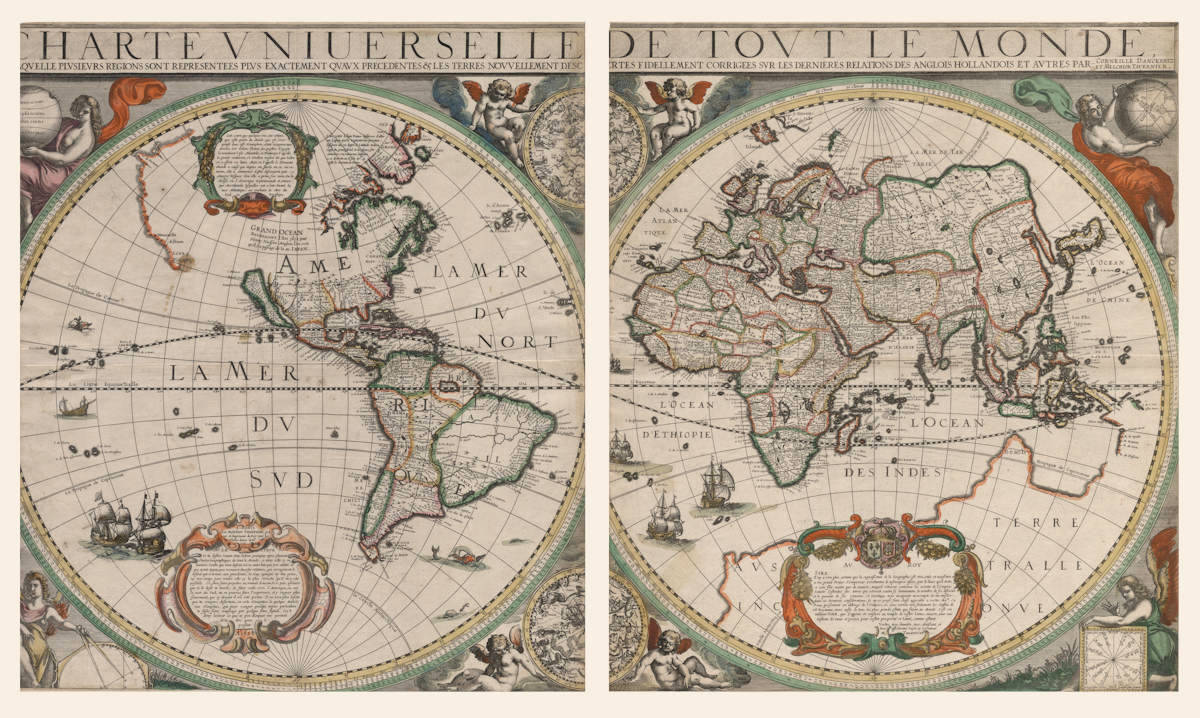
Antique map of the World by Danckerts-Tavernier
The item below has been sold, but if you enter your email address we will notify you in case we have another example that is not yet listed or as soon as we receive another example.

Stock number: 18988
Zoom ImageCartographer(s)
Danckerts-Tavernier
Title
Charte Universelle De Tout Le Monde
First Published
Paris, 1628
This Edition
1628 first state
Size
51.5 x 91.0 cms
Technique
Condition
excellent
Price
This Item is Sold
Description
Summary
Very large map of the world, printed on two sheets. It is the oldest printed map to show Carstensz's 1623 discoveries in Australia. Only six copies survive.
In 1623, following Jansz's 1606 discoveries, a new expedition was organized under the command of Jan Carstensz in the ships the Pera and the Arnhem to further explore the lands Jansz had happened upon some seventeen years earlier. On 21 January, 1623, Carstensz left Amhoina, finally reaching the area of Torres Strait by the end of March. Carstensz and his crew sailed south until they reached latitude 17° 8' south on 24 April, 1623. At this point the two boats turned around and parted company. Van Colster in the Arnhem sailed in a westerly direction, eventually charting some of the coastline to the west of the Cape. Carstensz on the other hand continued sailing north naming several places along Cape York Peninsula.
Currently no Australian institution holds a copy of this seminal map. The known institutional copies are held in the Library of Congress, the Bibliothèque Nationale and the British Library. Two copies are in private collections.
(Simon Dewez)
Condition
Thick paper. Printed on two sheets in fine original colour. Each hemisphere slightly trimmed at left hand side, slightly affecting the image. Otherwise excellent for an unobtainable map of highest significance.
Overall excellent appearance. Separately published - Paris 1628.
Provenance
Ex private collection, 2021.
Ex Gowrie Galleries, The Printed World III, item 59, 2000. Prominently on display in the corresponding exhibition In Search of Southern Soil - An exhibition of Rare Maps, Books and Globes, documenting the discovery of Terra Australis and Australia - 1482 to 1822. Queen Victoria Building, Sydney, Australia, March-April 2000.
Descriptions from the literature
Cornelis Danckerts - Melchior Tavernier
Paris, 1628.
515 x 910 mm.
"Charte Universelle De Tout Le Monde ... Par Corneille Danckertz et Melchior Tavernier"
"A Paris chez Melchior Tavernier ... A° 1628".
[Separate publication]
THIS UP-TO-DATE and well-constructed map printed on two sheets is the joint effort of Cornelis Danckerts from Amsterdam and the Parisian Melchior Tavernier who describes himself as graveur et imprimeur du Roy. The map is dedicated by Tavernier to the King of France and the title says that it has been corrected by the latest discoveries of the English, Dutch, etc. There are majestic cherubic figures in the spandrels and on either side of the central celestial hemispheres.
It is the first world map to mark, with names, Carstensz.' discoveries of 1623 on the western coast of [Cape York Peninsula in] Australia. The outline of the old southern continent is still shown on the eastern hemisphere but there is no such outline on the western part. In the Americas, the coastline beyond California is left uncertain; in the central part of north America a large inland sea is marked Grand Ocean with a note in French saying that this was discovered by Henry Hudson in 1612 and suggesting that it may provide a through route to Japan.
About four or five copies of this map survive. One is in the British Library and there is a coloured copy in the Library of Congress. The Bibliothèque Nationale and the University Library in Amsterdam also possess copies [The latter is now known to be a facsimile].
BL Maps 184.i.1.(2). Schilder, p. 96 and plate XVI.
(Rodney Shirley map 323)
The voyage of the Pera and Arnhem 1623
If the discoveries made in Australia by the Pera and the Arnhem are projected on to a modern map, the results of the expedition of 1623 can be summarized in cartographical terms as follows. On 14 April the two ships arrived at that point which was the farthest point previously reached by the Duyfken: the two ships then sailed down part of the west coast of Cape York Peninsula to 17° S, a stretch of coast which was unknown till then between Cape Keerweer and the Staaten or Gilbert River. The southernmost point was reached on 24 April. Thereafter the two ships began their return voyage mapping the coast carefully. After their separation only the Pera followed the prescribed north course and it may be that Carstensz discovered a small piece of coast not seen by the Duyfken south of Cape York and north of the northernmost point sighted by that ship. Van Colster on the Arnhem discovered the north-eastern extremity of Arnhem Land and the Wessel Islands in April-May 1623.
It is interesting that the discoveries of the Pera were very rapidly incorporated in maps and quickly became common property in the cartographical world, while the names mentioned on the Arnhem chart do not appear on a single known map. Until Tasman's second voyage in 1644 the discoveries of the Arnhem on the north-west shore of the Gulf of Carpentaria were entirely ignored: it was Tasman's view of the region of that Gulf that was accepted for the next century and a half.
The oldest extant cartographical evidence of Carstensz' expedition on a printed map seems to be on a Dutch-French world map dated 1628. Thus only five years after the expedition its results had reached Paris. In the title of the map, the source – the Dutch cartographer C. Danckerts – is mentioned. On the eastern hemisphere a large south-land appears, whereon are included four names derived from Carstensz' expedition.
The title of this beautifully executed and coloured French map is:
CHARTE VNIUERSELLE DE TOUT LE MONDE EN LAQVELLE PLVSIEVRS REGIONS SONT REPRESENTEES PLVS EXACTEMENT QVAVX PRESEDENTES & LES TERRES NOVVELLEMENT DESCOVVERTES FIDELLEMENT CORRIGEES SVR LES DERNIERES RELATIONS DES ANGLOIS HOLLANDOIS ET AVTRES PAR CORNEILLE DANCKERTZ ET MELCHIOR TAVERNIER. A PARIS chez Melchior Tauernier, graveur et Laprimeur du Roy pour les Tailles douces deme en l'Isle du Palais A° 1628.
Carstensz' voyage is represented with the following names: Tuleer muise I, Haulte terre, R. de Spult, R. Batavie, R. de Coen, R. de Naßou.
The earliest Dutch recordings [on printed maps] of the discoveries on the east side of the Gulf of Carpentaria are on the world map of Henricus Hondius of 1630 and the map of the East Indies by Willem Blaeu of 1635. The oldest English map on which the coasts of New Guinea and the eastern shores of the Gulf of Carpentaria appeared was the maritime atlas Dell'arcano del mare by Sir Robert Dudley, which atlas was published in Florence in 1646.
(Günter Schilder)
At a safe distance
India Orientalis nova descriptio (The East Indies), an early map of south-east Asia, is a landmark in the mapping of Australia Published by Johannes Janssonius in 1630, I was the first commercially available map to show any of the discoveries made in the Duyfken in any detail. The Duyfken's captain, Willem Janszoon, is thought to have been the first European to map any part of Australia. This was in 1606; however, the cartography was not generally available for a quarter of a century. By contrast, the world map by Amsterdam mapmaker Cornelis Danckerts (1603-1656) and Parisian publisher Melchior Tavernier (1594–1665), Charte universelle de tout le monde (Map of the entire world), published in 1628, shows the results of another expedition to the Gulf of Carpentaria just a few years earlier.
The map of the East Indies executed by Janssonius is of prime importance in the printed record of the Duyfken's voyage. It contains, albeit incompletely, the geographical results of the voyage under the command of Janszoon. On the south coast of New Guinea, the name Duyfkens Eylant is given, thereby immortalising the name of the ship associated with first mapping of Australia. The map does not show the entire route of the Duyfken, however, because it does not extend far enough south or east to include the ship's path along the coast of the Gulf of Carpentaria. While this may have been a deliberate omission, it is more likely to be the result of cartographic convention: Janssonius' map was framed according to an earlier map by Jodocus Hondius, Insulae Indiae Orientalis (Islands of East India) of 1613, itself based on the map by Abraham Ortelius in his atlas Theatrum Orbis Terrarum (Theatre of the world) of 1570. Hondius' map (and by default that of Janssonius), which was produced very shortly after the Dutch took control of the Spice Islands (Moluccas), did not allow for discoveries further to the south-east.
Nevertheless, after sailing down New Guinea's south coast, Janszoon crossed Torres Strait (which he believed to be a shallow bay) and continued along what he assumed to be the continuation of the coast of New Guinea as far as the Arukun Wetlands. Without realising it, he had become the first recorded European to land on Australian soil, on the west coast of Cape York Peninsula. Janssonius' map was first published in an atlas in 1630. It was not until the appearance of a newly engraved map, India que Orientalis dicitur, et insulae adiacentes (East Indies and adjacent islands), in 1635 that Dutch commercial maps of the region were extended to encompass all of Janszoon's Australian survey.
The discoveries of Janszoon, and even those of Jan Carstenszoon in command of the Pera and the Arnhem in 1623, soon began to appear on small-scale Dutch world maps. The first known representation was that printed by Danckerts and Tavernier in 1628. An impressive wall map, Charte universelle de tout le monde is known in only a few surviving examples. Significantly, it marks the names of the places Jan Carstenszoon mapped in 1623, when he revisited the Janzsoon discoveries. The discoveries are out of proportion, perhaps to fit with the extensive Terra Australle Inconue, suggesting that the places charted in Australia's north were part of the old southern continent. The survey conducted by Carstenszoon's deputy, Willem Joosten van Colster, in the Arnhem is also omitted. Indeed, the results of this survey, which mapped the north-eastern extremity of Arnhem Land and the Wessel Islands, were excluded from world maps until after Abel Tasman's northern Australian voyage of 1644.
Such anomalies are explicable in light of the VOC's well-known tendency to restrict information. When in 1605 Jan Willemsz. Verschoor, who was in charge of Dutch trade in the East Indies, sponsored a scheme ‘to discover the great land Nova Guinea and other unknown east and south lands’, it was a commercial decision. While the subsequent release of small-scale charting and a few place names was allowed, accurate mapping on a larger scale was much more tightly controlled.
(Martin Woods)
DANCKERTS, Cornelis / TAVERNIER, Melchior 1628
CARTE UNIVERSELLE DE TOUT LE MONDE en laquelle Plusieurs Regions sons representees plus Exactement quaux Precedentes & les Terres Nouvellement Descouvertes Fidellement Corrigees sur les Dernieres Relation des Anglois Hollandois et autre par Corneille Danckertz et Melchior Tavernier. A Paris chez Melchior Tavernier. A’o 1628 (in dedicatory panel lower left).
91.0 x 51.5 cms
This icon of Australian cartography (here in the first state) is considered the oldest printed world map to show Carstensz' 1623 discoveries in Australia. One of the earliest maps to depict California as an island. Only six or so copies survive.
Rodney Shirley notes the existence of only four or five copies of this splendid map. Of these, the copy held by the University Library in Amsterdam is now known to be a facsimile. The known institutional copies are held in the Library of Congress, the Bibliotheque Nationale and the British Library. There are two copies in private collections. Currently no Australian institution holds a copy of this seminal map.
In the first part of the 17th century, the Dutch East India Company (VOC) were establishing a trade monopoly in the East Indies - transporting spices and other highly desirable products back to the Netherlands. As Schilder notes, in 1605, as part of the expansive Dutch policies, Jan Verschoor who was then in charge of trade in the Dutch outpost at Bantam on the western coast of Java, sponsored a scheme to, “discover the great land Nova Guinea and other unknown east and south lands”. Willem Jansz was entrusted with the task of achieving this and so in 1605, in the pinnace the Duyfken, set sail from Bantam. After sailing along the south coast of New Guinea, Jansz failed to realise the true nature of Torres Strait; instead he sailed on down the west coast of Cape York Peninsula. Believing to be still navigating the New Guinea coastline, he in fact unwittingly became the first recorded European to land on Australian soil.
In 1623, a new expedition under the command of Jan Carstensz was organised to further explore the lands Jansz had happened upon some seventeen years earlier. On 21 January 1623, Carstensz left Amboina in the ships the Pera and the Arnhem, finally reaching the area of Torres Strait by the end of March. Carstensz and his crew sailed south until they reached latitude 17° 8' south on 24 April 1623. At this point the two boats parted company and embarked on their return journey. Van Colster in the Arnhem sailed in a westerly direction, eventually charting some of the coastline to the west of the Cape. Carstensz on the other hand continued sailing north naming several places on the Australian coast.
This world map by Danckerts and Tavernier, dedicated to the King of France, was a joint effort between the French and the Dutch and its importance to the mapping of Australia cannot be overestimated.
On it are recorded four of the place names given by Carstensz, on the Australian coastline - R. de Spult, R. Batavie, R. de Coen, and R. de Naßou. Also labelled is Haulte Terre or high ground.
Both Shirley and Schilder state that this is the oldest known printed map on which the discoveries of Carstensz on the Cape York Peninsula are shown. Interestingly, Shirley incorrectly states that the Carstensz discoveries were "on the western coast of Australia" - presumably an editorial error! The question of the existence of Terra Australis Incognita is left open as Danckerts shows the remnants of the fictitious coastline on the Eastern Hemisphere but no such coastline on the Western Hemisphere. Beach is prominently named on the northern most promontory of TERRE AUSTRALLE INCONNUE, a legacy of the 13th century travels of Marco Polo, who was supposed to have been informed of the existence of these three places south of Java. The names of these locations were subsequently misinterpreted as Beach, Lucach and Maletur.
The discoveries made by Schouten and Le Maire in 1616 are noted with Estroit Le Maire and I.de Guill:Schouten named.
This map is notable also for its early representation of California as an island and for its unusual placement of a substantial body of water on the central part of North America. A note on the map states (translated from the original French) Grand Ocean discovered by Hudson in 1612. It further suggests that via this Grand Ocean a sea route to Japan may be possible.
Shirley notes the existence of a second state of the map with the 1628 date now changed to 1639 and appearing in Tavernier's own 1640 atlas Theatre contenant la description de la Carte general de tout le Monde.
Shirley 323, pl.246; Shirley 1993 edition, Corrigenda and Addenda 323; Schilder illus. p.90, pl.XVI.
(Simon Dewez)
Texts legends on the map
Title:
CHARTE VNIUERSELLE DE TOVT LE MONDE, EN LAQVELLE PLVSIEVRS REGIONS SONT REPRESENTEES PLVS EXACTEMENT QVAVX PRESEDENTES & LES TERRES NOVVELLEMENT DESCOVVERTES FIDELLEMENT CORRIGEES SVR LES DERNIERES RELATIONS DES ANGLOIS HOLLANDOIS ET AVTRES PAR - CORNEILLE DANCKERTZ ET MELCHIOR TAVERNIER.
UNIVERSAL CHART OF THE WHOLE WORLD, IN WHICH MANY REGIONS ARE MORE ACCURATELY REPRESENTED THAN BEFORE & THE NEWLY DISCOVERED LANDS HAVE BEEN FAITHFULLY CORRECTED USING THE LATEST ACCOUNTS OF THE ENGLISH, THE DUTCH AND OTHERS. BY CORNELIS DANCKERTZ AND MELCHIOR TAVERNIER.
Cartouche in North America:
Cest a tort que quelques vns ont estimé que ceste partie du Monde qui est Comprinse dans cest Hemisphere, estoit incogneue aux anciens Car dedans Platon les prestres d'Egypte la nomment l'isle Atlantide, et Plutarque l'appelle le grand continent, Et Strabon mesme dit que Solon en a escrit un livre. Mais on l'appelle le Nouueau Monde a cause que depuis un siecle en ca, ou environ, elle a commencé destre descouuerte par Amerie Vespuce dou elle a prins fon nom. On la deuise, en l'Amerique Septentrionale et Amerique Meridionale lesquelles ont a leur leuant la mer Atlantique, au couchant la Mer du Sud ou Pacifique.
It is in error that some have believed that the part of the world which is included in this Hemisphere, was unknown to the ancients. For in Plato the priests of Egypt call it the island of Atlantis, and Plutarch calls it the great continent, And Strabo himself says Solon wrote a book about it. But it is called the New World because about a century ago, it was discovered by Amerigo Vespucci from whom it got its name. It is divided into North America and South America which have the Atlantic Ocean at their sunrise, and the South Sea or Pacific Ocean at their sunset.
Text legends in North America:
L'an 1586 Iehan Dauis desireux d'aller au Iapan par le Septentrion paruint Iusques au 72 degré de Latitude mais a cause du grand froid et des glaces fut constraint s'en retourner, laißant a ce destroit ou il fut arresté le Surnom de Davis.
In the year 1586 John Davis wishing to go to Japan by the North reached 72 degrees latitude but because of the great cold and the ice was constrained to return, leaving to this strait where he was stopped the nickname of Davis.
GRAND OCEAN descouuert l'An 1612 par Henry Hudson Anglois l'on croit qu'il y a paßage de la au IAPAN.
GRAND OCEAN discovered in the year 1612 by Englishman Henry Hudson, it is believed that there is passage from there to JAPAN.
Cartouche in the South Pacific:
A PARIS Chez Melchior Tauernier, graueur et Imprimeur du Roy pour les Tailles douces demé en l'Isle du Palais
IN PARIS by Melchior Tavernier, copperplate engraver and printer of the King, on the Île de la Cité
AV LECTEUR
Si tu desires Scauoir Amy lecteur, pourquoy apres plusieurs Chartes Geographiques de tout le Monde, je mets celle cy en lumiere: Scache que mon deßein n'a eu autre but que ton utilité. et que ayant depuis peu recouuert diuerses relations, qui corrigeoient le defaut qui se trouue aux precedentes, Ie n'ay epargné ny ma peine, ny mon temps pour rendre celle cy la plus correcte qu'il m'a esté poßible. Et sans faire prejudice au travail d'aucun, Ie te puis aßeurer que Si le desir te touche, de faire voile vers l'Amerique, ou sur la mer da Sud, tu en pourras faire l'experience, et y voguer plus Seurement, que ci deuant il n'a esté permis. Il ne sera plus besoin que tu craignes desormais, en ceste Nauigation la quelque Malicieux Nauplius, qui pour vanger quelque injure particuliere te faße faire naufrage par quelque faux signal. Cest Amy lecteur ce que ce peu d'espace me permet de te dire pour le present.
A.° 1628.
TO THE READER
If you want to know my reader friend, why after many Geographic maps of everyone, I bring this one to light: know that my drawing has no other purpose than your usefulness. And that having recently uncovered various accounts, which corrected the errors found in preceding ones, I have spared neither my trouble nor my time to make the most correct one possible for me. And without prejudicing the work of any, I can assure you that if the desire touches you, to sail towards America, or on the South Sea, you will be able to experience it, and to sail there more securely than was possible before. There will be no need for you to fear any longer, that in these waters some malicious Nauplius, who, to revenge some particular insult, will cause you to be shipwrecked by some false information. This is my reader friend what this little space allows me to tell you for the present.
Anno 1628.
Cartouche in the unknown Southland:
AV ROY
SIRE
Il ny a rien plus certain que la cognoißance de la Geographie est tres vtile et neceßaire a vn grand Prince. l'Empereur Constantin le tesmoigna aßez, par le liure qu'il doña a son filz auant que de mourir, auquel estoient contenuz les secretz de l'Empire: scauoir l'estenduë des terres qui estoient soubz sa domination, le nombre de ses Aßociez et le pouuoir de ses Ennemis. Et Iacoitque mon incapacité m'exempte de me mesler dans ces dernieres considerations, si ay-je pensé faire chose aggreable a vostre Majesté, En vous presentant cet abbregé de l'Vnivers, ou vous verrez non seulement les confins de votre Royaume, mais außy de tous les plus grands estats qui soient au Monde. Cest un tableau SIRE, que I'appens et consacre au temple de vostre Ianus ouuert, auec vne Infinite de væus et prieres pour vostre prosperité et Santé, comme estant
Vostre tres humble, tres obeißant et tres affectionné Sujet et Seruiteur
M. Tauernier
TO THE KING [Louis XIII of France]
SIRE
There is nothing more certain than that the knowledge of Geography is very useful and necessary for a great Prince. The Emperor Constantine testified to this quite enough, by the book which he gave his son before dying, in which were contained the secrets of the Empire: to know the extent of the lands which were under his domination, the number of his Allies and the power of his enemies. And because my incapacity prevents me from meddling in these last considerations, if I have thought to do something agreeable to your Majesty, By presenting to you this abstract of the Universe, where you will not only see the confines of your Kingdom, but beyond all the greatest states in the world. It is a chart SIRE, which I dedicate and consecrate to your open temple of Janus [refering to the ongoing Anglo-French War of 1627-29], with Infinite devotions and prayers for your prosperity and health, I remain
Your very humble, very obedient and very affectionate Subject and Servant
M. Tavernier
(Leen Helmink)
Related Categories
Related Items


