Leen Helmink Antique Maps
Antique map of the World by Verbiest
The item below has been sold, but if you enter your email address we will notify you in case we have another example that is not yet listed or as soon as we receive another example.

Stock number: 18979
Zoom ImageCartographer(s)
Pieter Verbiest (biography)
Title
Ampla et Accuratissima Universi Orbis Terrarum Tabula Geographica Aucta et Emendata Auct: I. verbist
First Published
Antwerp, 1630
This Edition
1630 first state
Size
46 x 56 cms
Technique
Condition
very good
Price
This Item is Sold
Description
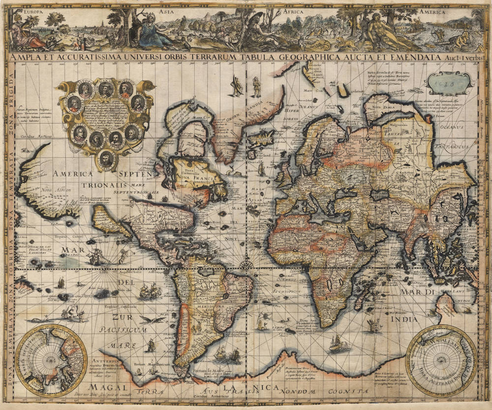
Iconic map of the world on Mercator's projection, decorated with the allegories of the four continents. It is one of the first maps to show the 1623 discoveries of the Pera and the Arnhem in the Gulf of Carpentaria.
Condition
A dark and even imprint of the copperplate. A very early imprint for certain, with the support lines for the toponyms still present. On thick paper. Attractive contemporary color. Minor loss of lower border, not affecting the map image. Tiny hole repaired in the large cartouche in North America. Vertical folds strengthened in the Pacific, Atlantic and the Indian Ocean, see also the image of the map verso.
With a French manuscript annotation on verso: "Table des quatres parties du monde" (Map of the four quarters of the world).
Overall in very good collector's condition.
Rarity
This is one of the rarest of all 17th century Dutch world maps and is considered unobtainable. Only two examples are recorded of this map, both of which are in the collection of the Bibilothèque national de France. One is an incomplete example of this first state with date 1630 (first state online here) but the allegories of the continents along the top have been cut off. The other is a complete example of a second state with the date changed to 1646 (second state online here).
That makes the example here:
- the third copy known,
- the second copy of the first state,
- the first complete copy of the first state.
No other examples are known. No copy in America. No copy in Asia. No copy in Australia. No copy in the Netherlands. No copy in the British Isles.
Importance
Even though the design and content of the map is largely derived from the 1622 map of the world by Pieter van den Keere, there are several geographical updates that make this world map of highest significance for the mapping of America, of the Pacific and of Australia.
A sailing passage completely with sailing ships through the middle of North America is assumed to exist all the way from Virginia flowing into the Pacific north of California. California has been updated with many new toponyms and is now and assumed to be an island. Peculiarly, this causes C. Mendocino to appear twice (once and the northwest coast and once on the island of California, and ditto for Francis Drake's landfall in California (Nova Albion on the mainland and P.o S.r Francisco Drac on the island of California. The east-west strait through North America runs past the legendary seven cities of Cibola (Ceptem Citta). This hypothesis goes back to John Smith, who had sent a letter about it to Henry Hudson. Hudson is known to have discussed it with Jodocus Hondius and Petrus Plancius, when he was called to the Netherlands to discuss a contract with the VOC for an expedition to explore a northeast passage to the East Indies.
At the southern tip of South America, toponyms deriving from the Nassausche Vloot are added next to those of Le Maire's expedition. In April 1623, Jacques l'Hermite had been commissioned by Prince Maurice of Nassau and the Dutch States General to lead a fleet of 11 ships to set sail on a circumnavigational voyage stopping on the coast of western South America Peru, with the instructions to hunt down Spanish silver ships leaving Peru and to establish a Dutch colony in either Peru or Chile. The plan failed, partly because l'Hermite and many of his crew died from dysentery and scurvy during the months long blockade of Callao, the port of Lima. He was buried on nearby San Lorenzo Island.
In the lower corners, Kaerius' depictions of the Temptation and of the Expulsion from the Garden of Eden have been replaced by insets of the polar hemispheres, allowing an unobstructed view of the northeast and northwest passage, as well as a clear view of the unknown Southland (Magellanica Terra Australis Incognita).
The north coast of New Guinea has been updated with the discoveries and toponyms from the 1615-1617 circumnavigation of Willem Schouten and Jacob Lemaire as published in their Mirror of the Australian Navigation.
Of high significance are the updates in northern Australia, one of the earliest recordings of the discoveries of the Pera and the Arnhem, an expedition that had been initiated in 1623 by Van Speult, the VOC Governor of Ambon. The expedition was under command of Jan Carstensz, a man with the necessary experience in the Company. Off the coast of Cape York we see the toponym Groene Eijlande (Green Islands), an intriguing reference that must come from this expedition but that is otherwise unrecorded. Local boats are depicted in the Gulf of Carpentaria and off the coast of today's Western Australia.
The oceans have been populated with many VOC ships, native vessels, monsters, flying fish, sea gods, mermen and mermaids. In the southern Atlantic, Neptune is waiving a flag with the coat of arms of the Iberian Union. This gesture to please the Spanish is no surprise, because Verbiest was working and living in Antwerp, which was not part of the free Netherlands but which was still occupied by the Spanish Empire.
Pieter Verbiest map of the world of 1630
Koeman records only one atlas for Verbiest, a collection of small maps of the Low Countries. However, Verbiest also produced some maps of individual countries and two rare world maps, both of which give acknowledgement to Isaak Verbiest, most probably his brother. The first of these general maps is on Mercator's projection, partly copying the Lons world map of 1622. Verbiest has added part of the lands found by the Dutch on the east coast of Australia. He has also made California a large island. An opening inland to the north is conjectured to lead through the Mare Septentrionale shown in the centre of North America to Hudson's Bay and Davis' Strait in the east.
Along the top of the map is a full-length panel describing the four continents in allegorical pictures. Ten leading explorers are commemorated by portraits around an oval panel of text; the latest to be so honoured is Jacques L'Hermite, 1623.
There is a later state with the date on the imprint amended to 1646. In both states the top right-hand cartouche is blank.
(Shirley)
WORLD on Mercator's projection
Pieter Verbiest, 1630
7.1 First state, by Pieter Verbiest, 1630
AMPLA ET ACCURATISSIMA UNIVERSI ORBIS TERRARUM TABULA GEOGRAPHICA AUCTA ET EMENDATA Auct: I. verbist
- No bar scale
- ANTVERPIA | Sumptibus Petri verbist | habitantis in Lombarde vest | ad intersigne America | Anno 1630. / Peter ver Bist sculpsit et excudit
- 1 map: copper engraving and etching; 46 x 56 cm
Pieter Verbiest (1607–74) was a member of a well-known Antwerp family of engravers and publishers. In 1630 he engraved and published this folio-size map of the world on Mercator's projection; his brother Isack is mentioned as the author. The title runs along the top edge of the map; the imprint is placed outside the cartouche in the left part of the imaginary Southland.
Verbiest's map is a close copy of Van den Keere's 1622 world map, with only some minor changes. Van den Keere's panels in the bottom corners are here replaced by two small polar hemispheres. The cartouche at the upper right has been left blank. To the large cartouche in North America a tenth portrait has been added, that of Jacques L'Hermite, commander of the so-called Nassausche Vloot (1623-26).
Above the title is a broad decorative border with etched allegorical personifications of the four continents. These are based on the 1581 series of prints by Jan Sadeler after Dirck Barendsz (Hollstein XXI, nos. 499-502). The figures are placed in a landscape in which the etcher could depict some characteristics and attributes of the continents more clearly.
When one compares the geographical content of Verbiest's map with van den Keere's of 1622, one notices only small changes. California is here shown as an island and a legend refers to a possible passage from here via a MARE SEPTENTRIONALE in the centre of North America to Davis Strait, explored by Henry Hudson. At the southern tip of South America, toponyms deriving from the Nassausche Vloot are placed next to those of Le Maire's expedition. In general, the drawing of the unknown Southland was copied from Van den Keere's 1622 map, while the shape of the south coast of New Guinea and a portion of the west coast of Cape York Peninsula were derived from Jan Carstensz's 1623 expedition in the Pera. A special feature is the drawing of Novaya Zemlya, which is strangely depicted as a peninsula extending far to the east.
Only copy known:
* Paris, Bibliothèque Nationale (Ge D 12273; the top border is cut off)
Literature:
Van Ortroy (1929) no. 16; Shirley (1983) no. 338; Hollstein XXXV, p. 180, no. 2/1
7.2 Second state, 1646
Date changed to 1646.
Only copy known:
* Paris, Bibliothèque Nationale (Ge D 12274)
Literature:
Van Ortroy (1929) no. 35;
Shirley (1983) no. 338;
Hollstein XXXV, p. 180, no. 2/II
(Schilder)
Pieter Verbiest (1607-1674)
Pieter Verbiest, or Peter Verbiest/Verbist / Petrum Verbist (Antwerp, 1607-1674) was born in Antwerp in 1607. He was active in this city all of his life as engraver, cartographer and publisher. He was also member of the Saint Lucas guild of artists. He died in 1674.
Verbiest produced a number of small maps that covered the area of the Seventeen Provinces and published these for the first time in 1636 as a pocket atlas. Only two copies have survived of this Novus Tabularum Geographicorum Belgicae Liber. Two more editions were published in 1644 and 1652.
Peter Verbiest also produced a number of significant and interesting maps, mostly in cooperation with his brother Isaak. The most famous is a world map in 1630 that was issued in Mercator's projection. It contains the most recent information on the Dutch explorations of Australia, and it follows the erroneous Spanish tradition by presenting California as an island.
(HisGISKust)
Related Categories
Related Items


