Leen Helmink Antique Maps
Antique map of Indian Ocean by Ramusio / Gastaldi

Stock number: 18946
Zoom ImageTitle
Seconda Tavola
First Published
Venice, 1554
This Edition
1554 first edition
Size
28.5 x 38.0 cms
Technique
Condition
excellent
Price
$ 6,500.00
(Convert price to other currencies)
Description
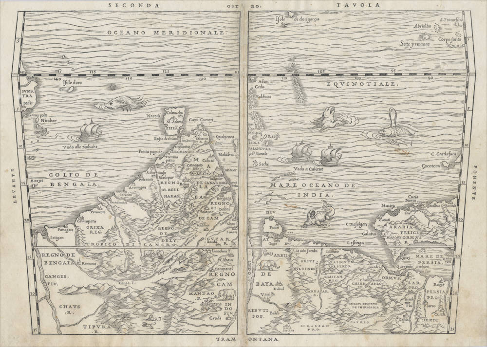
South-oriented map of the Indian Ocean, extending from western Sumatra through the Arabian Gulf. Two sailing ships and many sea monsters. The map was published by Giovanni Battista Ramusio in Volume I of his 'delle Navigationi et Viaggi', "the first great collection of travel literature" (Skelton). Author of the map is the famous cartographer Giacomo Gastaldi, also from Venice and a close friend of Ramusio.
1554 FIRST EDITION. Woodcut State I.
Of highest significance and rarity.
The first accurate map of the northern parts of the Indian Ocean and the Arabian Gulf, showing Portuguese India, with first Calicut and later Goa as their political, military and episcopal center. The map covers he sea routes from eastern Africa (Socotra Island), the Arabian Peninsula, the Arabian Gulf (with Bahrein and an early depiction of an Emirates port city, the Portuguese strongholds of Hormuz, Diu, Goa and Cochin. The Maldivas are shown, as well as the little island of Diego Garcia. Ceylon is accurately positioned, With Adam's Peak marked. The Indian peninsula is decorated with elephants, a lion and a hunting scene. In the east the map extends to the Gulf of Bangala with the Ganges estuary and to northern Sumatra, with the port of Atjeh (Pedir) and the Nocobar islands.
Portuguese caracks are depicted full sail on their way to Calicut (Vado a Calicut) and en route to the Spice Islands (Vado alle Moluche). The Indiamn Ocean is filled with many sea monsters.
The map is simply titled "SECONDA TAVOLA" (Second Map), from Ramusio's First Volume of his collection of Voyages. The map is oriented with south at the top, as Europeans would often draw it from their perspective of the sea routes to the east. Outside the map, the directions of the compass are given as directions of the Italian winds, as was customary in the early days of exploration: OSTRO (South), PONENTE (West), TRAMONTANA (North), and LEVANTE (East).
The map uses Prtolemy;s old trapezoid projection, in a crude effort to reflect the curvature of the earth. The equator (EQUINOTIALE) has marks running from 85-145 degrees longitude. North of the equator (so the lower part of the map), the latitude marks go up to 35 degrees north, and the Indian Ocean is named MARE OCEANO DE INDIA (Indian Ocean). South of the equator (so the upper part of the map), the latitude marks go up to 9 degrees south, and the Indian Ocean is named OCEANO MERIDIONALE (Southern Ocean). The Portuguese sea route to the Indies was to sail along the coasts of Africa and Asia, using the monsoon seasons that the Arabs traditionally used. The routes to the Indies via the southern Indian Ocean were not used until the Dutch VOC entered the Indian Ocean theater half a century later.
According to Ramusio's introduction to the book, the maps are the work of his friend Giacomo Gastaldi, the greatest of all Italian mapmakers.
Condition
Verso blank. Overall and excellent collector's copy.
Giovanni Baptista Ramusio (1485-1557)
Ramusio is the first overview work of voyages of discovery. It was first published in 1550 (Volume 1, but not with maps until 1554), 1559 (Volume 2) and 1557 (Volume 3). All were published in Venice.
"Though he himself traveled little, Ramusio published Navigationi et Viaggi ("Navigations and Travels"); a collection of explorers' first-hand accounts of their travels. This was the first work of its kind. "Delle navigationi et viaggi" (Navigations and Travels) is a collection of explorer's first-hand accounts of their travels. It was the first work of its kind. It included the accounts of Marco Polo, Niccolò Da Conti, Magellan, Alvar Nuñez Cabeza de Vaca and Giosafat Barbaro, as well as the Descrittione dell’ Africa. The description of China contains the first reference in European literature to tea. He also published an excerpt of Tomé Pires' work on the Indies, which had come into his hands, though he did not know the name of its author. The first volume was published in 1550, quickly followed by the third volume in 1556. Publication of the second volume was delayed because the manuscript had been destroyed in a fire before being sent to the printer, and was finally published in 1559, two years after its compiler's death. Navigationi et Viaggi was translated into several languages and reprinted a number of times, indicating how popular such books were becoming on the Continent. It paved the way for a slew of other such works, including those of Richard Hakluyt."
(Wikipedia)
Giacomo (Jacopo) Gastaldi (c.1500-1566)
"In Venice in 1548, Giacomo Gastaldi engraved a fine series of maps for what is seen as the first 'pocket' or miniature atlas."
(Potter p38)
"Praised as 'that most excellent of cartographers', Gastaldi was a native of Piedmont and worked in early life as an engineer in the service of the Venetian Republic before turning in the early 1540s to cartography as a profession. Eventually he was appointed Cosmographer to the Republic.
From 1544 onwards he produced a large number of maps beautifully engraved on copper, using a style which was widely copied by his contemporaries, indeed, his technique marked the final transition away from woodblock printing which had been predominant for so long.
Apart from compiling maps of the world and the continents he was responsible for the maps in an edition of Ptolemy issued in 1548 and in a noted collection of voyages and travels called 'Delle Navigazioni e Viaggi' by Giovanni Battista Ramusio (1485-1557). Many of his maps were included in the Lafreri collections of maps in the 1560–80 period.
Gastaldi is credited with popularizing the idea that a route round the north of the American continent led to a passage which he called the Strait of Anian, named after Marco Polo's Kingdom of Anian. The name appeared on many maps well into the seventeenth century."
(Moreland & Bannister p66)
"Jacopo Gastaldi, 'most excellent' of cosmographers, produced a pocket version of Ptolemy in 1548. 'La Geografia di Claudio Ptolemeo' (with 'criticisms and additions' by Sebastian Münster) contained 26 maps from Ptolemy [..], and 34 new maps (some of the New World)."
(Tooley & Bricker)
"Jacopo Gastaldi, born in Piedmont in about 1500, and by the 1540s cosmographer to the Venetian Republic. At least a hundred maps are attributable to Gastaldi, including his 1548 'Geographia' (published by Nicolo Bascarini). It was a popular edition in Italian prose, and expressly designed in quarto, with maps only 5 by 6.75 inches, so that it could be carried 'nella manica' - in the sleeve. (Quarto is the page size that results when a full-sized printed sheet is folded twice instead of a single time that gives a 'folio' page.).
Gastaldi's contemporaries usually described him as the 'most excellent Piedmontese cosmographer'. As a dedicated professional he worked for a number of publishers, accepting occasional private commissions, as when Venice's all-powerful Council of Ten commissioned him to make fresco maps of Asia and Africa for the walls of a room in the Doge's Palace"
(Tooley & Bricker)
"A small but very elegant Italian [Ptolemy] edition with plates, handsomely engraved in copper by the famous cosmographer Gastaldi. [...]. A whole series of plates of the New World is here met with, for the first time, and some of them are of no slight interest to the history of cartography."
(Nordenskjöld 28)
"Sixty maps are engraved in copper in Mattiolo-Gastaldi's Ptolemy of 1548. [...]. On the title-page is written: 'Con alcuni comenti et aggiunti fattevi da Sebastiano Munstero Alamanno, but this evidently refers to the text, not to the maps, which, from a geographical point of view as well as in their technical execution, are immensely superior to those of the learned geographer and Hebrew professor at Basel.
The work is dedicated by Iacobo Gastaldi to Leone Strozzi, 'dignissimo Signore di Capua', whereupon follows an 'A li lettori', where the publisher, Giovanbattista Pedrezano, is highly complimented, for not having spared any expense in getting the maps as finely and well executed as possible, and for having reduced their size as to allow of anybody, without difficulty, carrying the work 'nella manica'. We thus have here the first atlas expressly said to be published in a pocket form."
(Nordenskjöld 40)
"This edition of Ptolemy's 'Geography' was the most comprehensive atlas produced between Martin Waldseemüller's 'Geographia' of 1513, and the Abraham Ortelius 'Theatrum' of 1570. It was the first to contain regional maps of the American continent.
Giacomo Gastaldi had the maps beautifully engraved on copper. This marks a turning point, from now on the majority of cartographic works used this medium. As it was a harder material than wood it gave the engraver the ability to render more detail. Born in Villafranca, Piedmont, Gastaldi became Cosmographer to the Venetian Republic, then a powerhouse of commerce and trade. He sought the most up to date geographical information available, and became one of the greatest cartographers of the sixteenth century."
(Burden 16)


