Leen Helmink Antique Maps
Antique map of China by Ortelius


Stock number: 18936
Zoom ImageCartographer(s)
Abraham Ortelius (biography)
Title
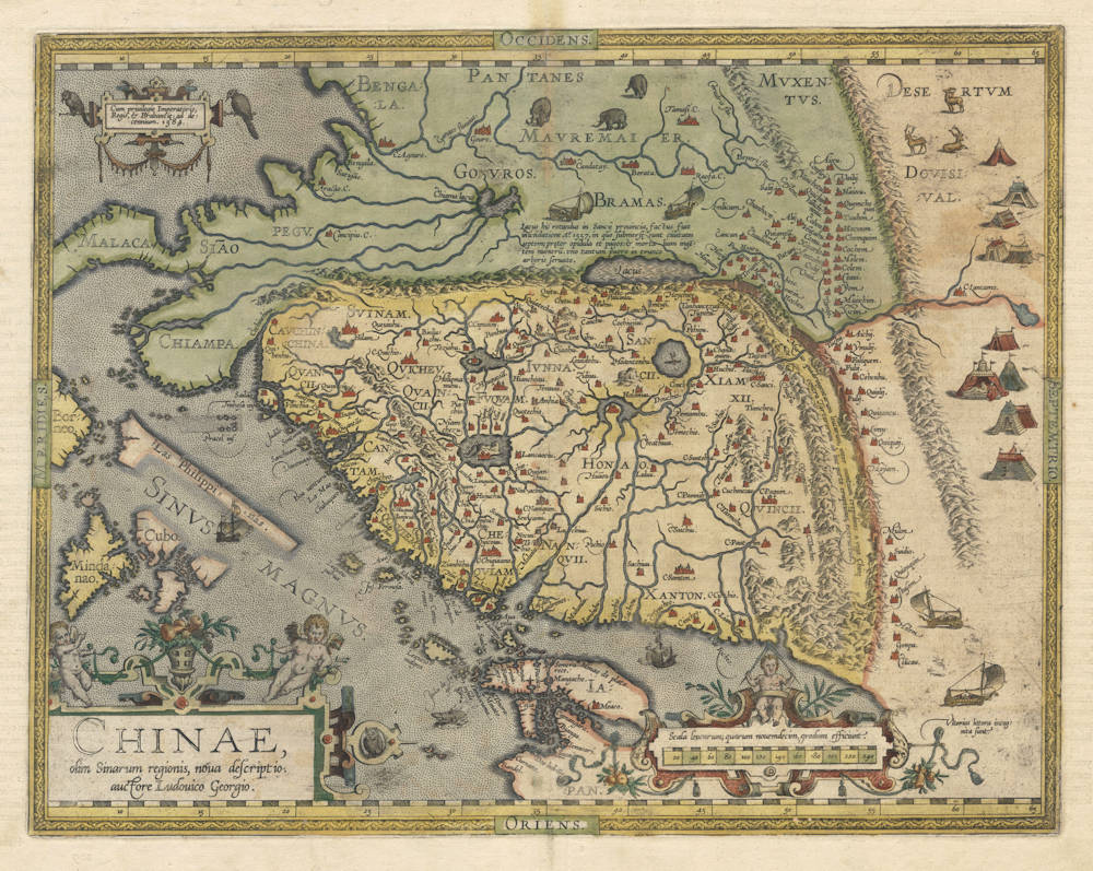
Chinae, olim Sinarum regionis, nova descriptio.
First Published
Antwerp, 1584
This Edition
1603 Latin
Size
36.4 x 46.6 cms
Technique
Condition
mint
Price
This Item is Sold
Description
The first published map of China.
Condition
A superb example, from the 1603 Latin edition. Second state of the copperplate, which is the earliest map to name the Philippines (Las Philippinas).
Full-body old colour by the publishing house. Thick paper with very wide margins. A supreme collector's example of this iconic map.
Summary
A seminal map of China published by Ortelius from 1584 onwards. The map had been compiled by Luiz Jorge de Barbuda, a Portuguese Jesuit missionary. West is at the top of the map. Three decorative cartouches. Pictures of Tartarian wagon-dwellers, sailing wagons, elephants and reindeer fill the unknown areas north and east of China.
The map is a "first" in many ways:
- The first published map of China
- The first map to show the Chinese Wall
- The first map or print to show sailing wagons
- The first western print to show Chinese characters (on verso)
- The first map to name the Philippines (from the second state onwards)
Along the Chinese wall is the following text:
Murus quadringentarum leacarum, inter montium crepidines a rege Chine / contra Tartarorum ab hac parte eruptiones, extructus.
A wall of 400 leagues, between the banks of the hills, built by the King of China against the breaking in of the Tartars on this side.
"Ludovico Giorgio's map of China, adapted for the 1584 edition of Ortelius' 'Theatrum', was the first map of China to appear in a European atlas. 'Ludovico' was Luiz Jorge de Barbuda, a Portuguese cartographer and author of a 'Description of China'. He was a spy, too, and for his Spanish employers he 'discovered many secrets' among the old charts and rutters to which he had access."
(Tooley & Bricker).
"Compiled by Barbuda, a Portuguese Jesuit missionary, this famous map remained the standard map of China for about half a century. Barbuda used the signature 'Ludovico Georgio'."
(Moreland & Bannister).
Ortelius Map No. 164
Cartographic sources: Luiz Jorge de Barbuda or Ludovicus Georgius who made a manuscript map of China which reached Ortelius in 1580 via Arias Montanus.
When this map appeared, it was by far the most accurate one of China. Japan is shown on a curious curved projection reminiscent of Poruguese charts of the period with Honshu dissected along the line of Lake Biwa. The Great Wall is shown but with 400 miles only; its length is grossly underestimated. The Tartar "yurts" are dotted across the plains and steppes of Central and East Asia.
The text on verso includes four transcriptions of Chinese characters, brought back to Europe by the Jesuit Bernadino Escalante, published in Sevilla in 1577.
Note the four wind waggons on the right and top of the map, perhaps the earliest examples of a depiction of this device, which in Europe is certain to have originated in the Low Countries, but which had been invented much earlier in China. The wind waggon is well documented in a treatise in Dutch on the subject by Simon Stevin which appeared in Dutch in the year 1600.
(Marcel van den Broecke, orteliusmaps.com)
The Ortelius Map of China, 1584
In 1584, Ortelius composed a map of China, Chinae, olim Sinarum regionis, nova descriptio, based on data compiled by Luis Jorge de Barbuda, a Portuguese in the service of Philip II of Spain.
Ortelius shows Mindanao, and some islands to the north, but only Cubo (Cebu) is marked. Formosa is better formed than on his 1570 map of Asia, but the most curious part of Southeast Asia on this map is the long, diagonal island just north of Borneo. This is, of course, the position and orientation of Palawan, yet the island depicted here is clearly not based on information from Spanish expeditions approaching from the east, as those shores have been left hypothetical. In fact, if we look back at some earlier Portuguese charts, we find a series of closely-spaced islands forming a coastline similar to Ortelius'. The Lisbon chartmaker Reinaldo de Carvalho, in a map of 1563, depicts this archipelago, labeling it as Costa de Incõis, and similar configurations are found on the sea charts of Sebastião Lopes and Fernão Vaz Dourado; they are commonly accompanied by comments about a Chinese presence in these islands’ waters. Whereas Magellan and subsequent Spanish explorers had approached Palawan from the east, our Costa de Incõis, like the interesting depiction of Palawan found on the 1548 map by Gastaldi, probably represents the occasional sightings of Palawan's western shores by Portuguese vessels heading round the Southeast Asian mainland, bound for China.
On the first state of the Ortelius Chinae, this landmass is not identified. Later impressions, however, bear the name Las Philippinas — the first time on a printed map that the name is applied to the archipelago rather than one island. Five years later, on his Maris Pacifici, Ortelius divided the Philippines between the Philippinas to the south, and the Lucoes to the north (though Luzon itself is not shown). The transference of the term to include the whole archipelago had already occurred in manuscript maps.
(Thomas Suárez, Early Mapping of Southeast Asia).
Abraham Ortelius (1527-1598)
Abraham Ortelius is the most famous and most collected of all early cartographers. In 1570 he published the first comprehensive collection of maps of all parts of the world, the Theatrum Orbis Terrarum ("Theatre of the World"), the first modern atlas as we know it.
"Abraham Ortel, better known as Ortelius, was born in Antwerp and after studying Greek, Latin and mathematics set up business there with his sister, as a book dealer and ‘painter of maps'. Traveling widely, especially to the great book fairs, his business prospered and he established contacts with the literati in many lands. On one such visit to England, possibly seeking temporary refuge from religious persecution, he met William Camden whom he is said to have encouraged in the production of the Britannia.
A turning point in his career was reached in 1564 with the publication of a World Map in eight sheets of which only one copy is known: other individual maps followed and then – at the suggestion of a friend - he gathered together a collection of maps from contacts among European cartographers and had them engraved in uniform size and issued in 1570 as the Theatrum Orbis Terrarum (Atlas of the Whole World). Although Lafreri and others in Italy had published collections of ‘modern' maps in book form in earlier years, the Theatrum was the first uniformly sized, systematic collection of maps and hence can be called the first atlas, although that term itself was not used until twenty years later by Mercator.
The Theatrum, with most of its maps elegantly engraved by Frans Hogenberg, was an instant success and appeared in numerous editions in different languages including addenda issued from time to time incorporating the latest contemporary knowledge and discoveries. The final edition appeared in 1612. Unlike many of his contemporaries Ortelius noted his sources of information and in the first edition acknowledgement was made to eighty-seven different cartographers.
Apart from the modern maps in his major atlas, Ortelius himself compiled a series of historical maps known as the Parergon Theatri which appeared from 1579 onwards, sometimes as a separate publication and sometimes incorporated in the Theatrum."
(Moreland and Bannister)
"The maker of the ‘first atlas', the Theatrum Orbis Terrarum (1570), started his career as a colorist of maps. Later, he became a seller of books, prints and maps. His scientific and collecting interests developed in harmony with those of a merchant. He was first and foremost a historian. Geography for him was the ‘eye of history', which may explain why, in addition to coins and historical objects, he also collected maps. On the basis of his extensive travels through Europe and with the help of his international circle of friends, Ortelius was able to build a collection of the most up-to-date maps available.
The unique position held by Ortelius's Theatrum in the history of cartography is to be attributed primarily to its qualification as ‘the world's first regularly produced atlas.' Its great commercial success enabled it to make a great contribution to ‘geographical culture' throughout Europe at the end of the sixteenth century. Shape and contents set the standard for later atlases, when the centre of the map trade moved from Antwerp to Amsterdam. The characteristic feature of the Theatrum is that it consists of two elements, text and maps. Another important aspect is that it was the first undertaking of its kind to reduce the best available maps to a uniform format. To that end, maps of various formats and styles had to be generalized just like the modern atlas publisher of today would do. In selecting maps for his compilation, Ortelius was guided by his critical spirit and his encyclopaedic knowledge of maps. But Ortelius did more than the present atlas makers: he mentioned the names of the authors of the original maps and added the names of many other cartographers and geographers to his list. This ‘catalogus auctorum tabularum geographicum,' printed in the Theatrum, is one of the major peculiarities of the atlas. Ortelius and his successors kept his list of map authors up-to-date. In the first edition of 1570 the list included 87 names. In the posthumous edition of 1603, it contained 183 names.
Abraham Ortelius himself drew all his maps in manuscript before passing them to the engravers. In the preface to the Theatrum he stated that all the plates were engraved by Frans Hogenberg, who probably was assisted by Ambrosius and Ferdinand Arsenius (= Aertsen). The first edition of the Theatrum is dated 20 May 1570 and includes 53 maps.
The Theatrum was printed at Ortelius's expense first by Gielis Coppens van Diest, an Antwerp printer who had experience with printing cosmographical works. From 1539 onwards, Van Diest had printed various editions of Apianus's Cosmographia, edited by Gemma Frisius, and in 1552 he printed Honterus's Rudimentorum Cosmograhicorum... Libri IIII. Gielis Coppens van Diest was succeeded as printer of the Theatrum in 1573 by his son Anthonis, who in turn was followed by Gillis van den Rade, who printed the 1575 edition. From 1579 onwards Christoffel Plantin printed the Theatrum, still at Ortelius's own expense. Plantin and later his successors continued printing the work until Ortelius's heirs sold the copperplates and the publication rights in 1601 to Jan Baptist Vrients, who added some new maps. After 1612, the year of Vrients's death, the copperplates passed to the Moretus brothers, the successors of Christoffel Plantin.
The editions of the Theatrum may be subdivided into five groups on the basis of the number of maps. The first group contains 53 maps, 18 maps were added. The second group has 70 maps (one of the 18 new maps replaced a previous one). In 1579 another expansion was issued with 23 maps. Some maps replaced older ones, so as of that date the Theatrum contained 112. In 1590 a fourth addition followed with 22 maps. The editions then had 134 maps. A final, fifth expansion with 17 maps followed in 1595, bringing the total to 151."
(Peter van der Krogt, Atlantes Neerlandici New Edition, Volume III)
 by Bellin")


