Leen Helmink Antique Maps
Antique map of the World by de Wit / Ottens
The item below has been sold, but if you enter your email address we will notify you in case we have another example that is not yet listed or as soon as we receive another example.

Stock number: 18919
Zoom ImageTitle
Nova Totius Terrarum Orbis Tabula Auct. F. de Wit
First Published
Amsterdam, 1680
This Edition
Amsterdam, c.1730
Size
107.5 x 125.0 cms
Technique
Condition
mint
Price
This Item is Sold
Description
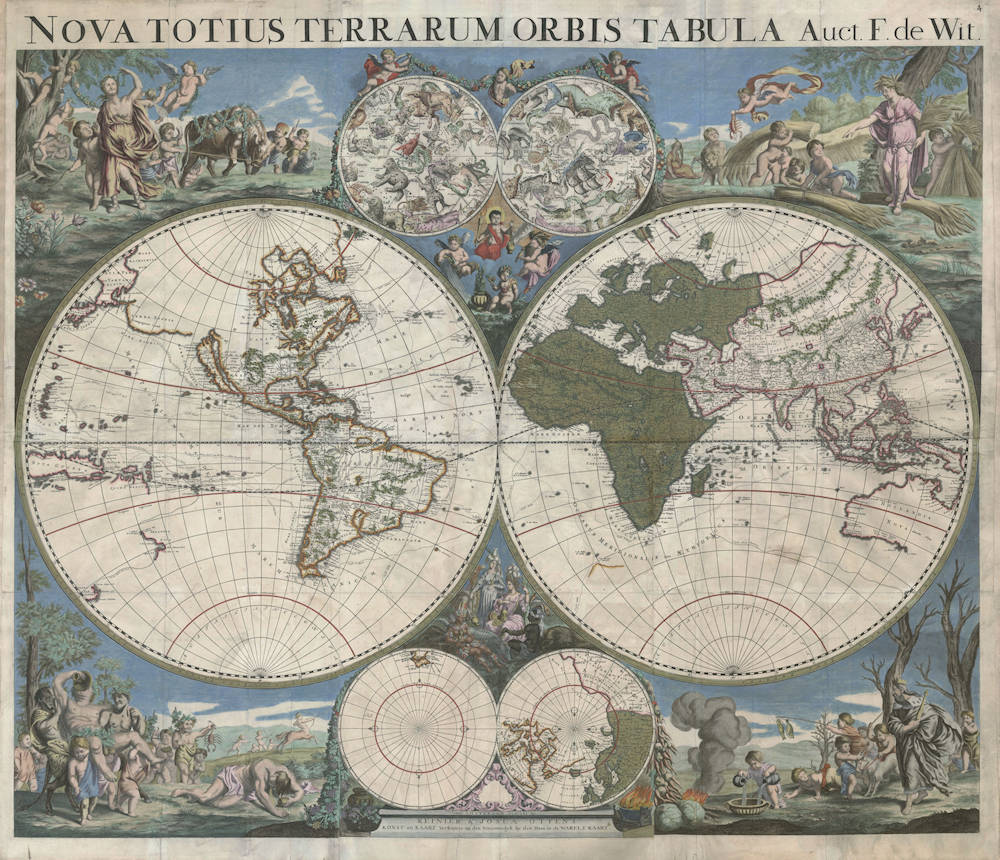
The legendary large six sheet wall map of the world by Frederick de Wit, first published in c.1680, here in its final updated state by Reinier and Josua Ottens of c.1730. A cartographical landmark.
Second copy known.
Condition
Strong and even imprint of the copperplates. Ample margins all around. Attractive contemporary color. Pristine overall condition, which is highly unusual for wallmaps.
Frederick de Wit’s Wall Map of the World in Six Sheets in its final state
The only wall map of the world with the tracks of Tasman, proving that Australia was a separate continent, not part of an unknown Southland.
The only wall map of the world with the tracks of De Quirós, Meñdana and Gallego in their attempts to colonize the unknown Southland.
A large visual icon for the early voyages in search of Australia.
NOVA TOTIUS TERRARUM ORBIS TABULA Auct. F. de Wit.
First state: Amsterdam, F. de Wit, ca 1680. Here in second state, R. and J. Ottens, ca 1730.
Printed on six sheets: copper engraving and etching.
Total size 107.5 x 125 cm.
Two hemispheres in equatorial projection, Ø 62 cm each.
Impressum:
REINIER & JOSUA OTTENS, KONST en KAART Verkopers op den Nieuwendyk by den Dam in de WARELT KAART.
In the field of wall map production, the first half of the seventeenth century is dominated by the prominent Dutch publishers Blaeu and Hondius. In the second half of the seventeenth century, this role is taken over primarily by Frederick de Wit, and to a somewhat lesser degree by the families Allard, Visscher and Danckerts.
After De Wit (1629/30-1706) established himself in Amsterdam in c. 1648, he first worked for Joan Blaeu for a few years.
His own first atlas appeared in 1660 and contains a world map in folio size (Shirley 421). From 1660 until 1706, his business on the corner of Dam Square and Kalverstraat was the foremost publishing house in Amsterdam and well beyond. In the years 1660 to 1672 he published seven world maps, four of them in folio, and three wall maps, in 12, 4 and 21 sheets respectively. In ca 1680 another wall map is published in 6 sheets (this one) and in ca 1690 another one in 8 sheets. His maps were popular objects at the time.
After Frederick de Wit’s death in 1706, much of the copperplates were bought by Pieter Mortier and subsequently reissued by him and his successors. Joachim Ottens (1663-1719), who worked in the De Wit's publishing house, also bought a batch of De Wit's copperplates and then re-issued them in an adapted form.
This also happened with the De Wit's world map in six sheets, which is known to us in an edition of his sons Reinier and Joshua Ottens. Both the first edition of this map as well as the reissue are only known in one copy (British Library, London, University Library, Amsterdam) (see Shirley entry 500).
The wall map shows an abundance of decorations with symbolic themes, which makes this a very attractive depiction of the world. In the upper part between the two hemispheres the northern and southern starry sky (Ø 20.5 cm) are included, with four putti with attributes to symbolize the four classical elements (earth, water, fire and air).
In the lower part between the two hemispheres are polar projections of the Arctic and Antarctic regions (Ø 20.5 cm), together with the allegorical female figures representing the known four continents, with Asia, America and Africa paying tribute and homage to Europe.
In the four corners of the wall map are copperplate etched allegorical images of the four seasons. These are enlargements of similar allegories used on Frederick de Wits folio world map of c.1671, of which Shirley writes: “The brilliant scenes in the corners combine images of the four seasons, the elements, and the signs of the zodiac, in a well-balanced and a naturalistic way” (Shirley 451).
The upper left corner depicts the season of spring, with the associated zodiac signs of Aries, Taurus, and Gemini (the Ram, the Bull, and the Twins). The upper right corner has summer, with the signs of Cancer, Leo and Virgo (the Crab, the Lion, and the Virgin). Autumn is in the lower left corner, with the signs of Libra, Scorpio and Sagittarius (the Scales, the Scorpion, and the Centaur Archer), Winter is in the lower right corner, with the signs of Capricorn, Aquarius and Pisces (the Goat Mountain, the Water-Bearer, and the Fish). The classical elements of earth, air, water and fire can also be discerned in these corner scenes.
Geographically, there is much progress in comparison with the 1655-1658 second edition of Joan Blaeu's 1648 large wall map of the world (Shirley 371), which was the gold standard at the time. In the interior of North America, the large inland lake has been replaced by an improved depiction of the Great Lakes. Japan has been completely changed. The northeast end of Siberia is now on the western hemisphere with name Tartaria and is almost connected to Japan and to a large landmass Terra Esonis (Compagnies Land), sighted in bad weather by Maarten de Vries in 1643 and believed to stretch as far as America. These adjustment to Blaeu’s wall map have however not been added to the Arctic map at the bottom. The Caspian Sea has a north-south orientation instead of the horizontal oval shape used on maps before. The coastlines on the east side of the island of Spitsbergen have been expanded.
On the southern hemisphere and Pacific, New Guinea now consists of two islands of Terra dos Papos and Nova Guinea, with the latter situated on the western hemisphere. To the east, part of the Quiri Regio (“Land of Quiroz)” has been added, Quiros’ then mysterious discoveries in Vanuatu. Mira Como Vaz (“watch where you’re going”) gratuitously marks the strait between New Guinea and Quiri Regio.
Interestingly, New Guinea is separated from Australia by a "Torres" strait that the Dutch explorers had never been able to find coming from the west. Torres had discovered it 1606, coming from the Pacific Ocean eastern entrance, after De Quirós's ship had returned to Mexico, but this discovery was secret and not known when this wall map was published. In 1769 the Scottish geographer Alexander Dalrymple, whilst translating some Spanish documents captured in the Philippines in 1762, had found Luís Vaz de Torres' account proving a passage south of New Guinea. This discovery recorded in Spanish maps of the Pacific would later later greatly facilitate James Cook's expedition to Australia
The map image as a whole is consistent with the 1660 folio map of Nicolas Sanson (Shirley 419) and its enlargement on the 1669 wall map in six sheets of his sons Guillaume and Adrien (Shirley 445). Both of these maps were published by Pierre Mariette in Paris. It is obvious that Frederik de Wit was acquainted with these maps.
Despite the fact that the publication of Reinier and Joshua Ottens appeared almost fifty years after the first edition, the name of F. de Wit was not removed and the cartographic image itself remained unchanged, except that Saint Petersburg has been added, founded by Tsar Peter the Great in 1703.
However, what makes this edition of the Ottens brothers stand out is the addition of navigation routes of famous explorers. The plotting of these voyages is what renders this world map into an unrivaled cartographic icon. With the help of these routes, the navigation tracks of the great voyages of discovery can be followed and the unveiling of the world is brought to light. One can follow many of the famous circumnavigations of the world, beginning with Fernando de Magellan (1519-1522), his journey included up to his death in the Philippines [Cursus Magellanis]. In his footsteps follows the Englishman Francis Drake (1577-1580), his route [Cursus Fr. Drak] from Panama to his landing on the northwest coast of California (P. de Franc. Draco). The first Dutch circumnavigation by Olivier van Noort (1598-1601) is plotted crossing the Pacific from Central America to the Philippines [Cursus Oliverii de Noord]. The route of the next Dutch circumnavigation by Joris van Spilbergen (1614-1617) is depicted in full [Cursus Spilbergii]. While Spilbergen still sailed through the Strait of Magellan, the expedition of Jacob le Maire (1615-1617) discovered a new connection between the Atlantic and the Pacific using Le Maire Strait. His route from the Netherlands through the Le Maire Strait and across the entire Pacific Ocean to the north coast of New Guinea has been plotted [Cursus le Mairi].
On the American east coast are three further routes, which are related to the search of a sea route to Asia: The route taken in 1492 by Columbus [Cursus Columbi] on his first voyage leading to the discovery of America, the route of Henry Hudson (1610/11) [Cursus Hudzoni] with the fatal wintering in Hudson Bay, and the journey under Danish authority of Jens Munk (1619-1620) [Cursus Munkii]. The latter two were searching a northwestern sea rout to Asia. The quest for a northeastern sea route to Asia is represented by the 1595/97 polar voyage of Heemskerk and Barentsz [Cursus Heemskerkii], with the wintering in Nova Zemla. Barentsz earlier voyage to Vaygat Strait is also included.
In the North Pacific we see the track of João da Gama [Cursus D. Ioannis the Gama ex China in Novam Hispaniam] and the one of Juan Gaetano [Cursus Gaetani], who sailed in 1542 from Mexico to the Philippines and the Moluccas.
The historical quest for the unknown South Land has received special attention on this world map. It was initiated in the second half of the sixteenth century by the Spaniards from the American
west coast.
In 1567/68 two ships were sent from Callao (Peru) under command of Alvaro de Meñdana de Neira, with Hernando Gallego as chief pilot, to find and colonize the Southland [Via Quam in Primo Itinere Mendonna et Gallego Tenuerunt 1568]. The South Land could not be found, but the Solomon Islands were discovered.
During the second voyage in 1595/97, with Pedro Fernandez de Quirós as chief pilot [Via Secundo Itineris Mendonna et Fransici Quiri 1595], however, the Salomon islands reached on the first voyage could not be found again. They did discover the Marquesas and the Santa Cruz Islands.
De Quirós was obsessed with Terra Australis and eventually in 1605 he was able to sail from Callao with three ships [Cursus Quiroi] to discover and Christianize the austral continent once and for all. He discovered land in May 1605 (one of the New Hebrides) which he considered to be the long-sought South Land. On this world map, this area is named Quiri Regio, and includes the toponyms of this trip.
What makes our world map extraordinary is the plotting of the important route of Abel Tasman's first voyage of discovery of 1642/43 [Cursus Abelis Tasmanni], which discovered the true nature of the Southland and added new discoveries to the Pacific Ocean. The entire route taken by Tasman is plotted, starting from the island of Mauritius, the discovery of Tasmania [Terra van Diemen], the crossing of the current Tasman Sea, and the discovery of the west coasts of New Zealand [Zeelandia Nova], where a continuous coastline is assumed, after suspecting but failing to discover Cook’s Strait. From here the Tasman journey continued northward where Tonga and Fiji Islands were discovered. Via the north coast of New Guinea, this voyage of discovery returned to Batavia. Interestingly, this world map shows a strait between New Guinea and Cape York, suggesting that the Dutch mapmakers had knowledge of Torres’ 1606 discovery of the strait.
The most recent tracks on the map are the voyages of Edmond Halley in 1699/1700 [Cursus Hallei], whose studies had a major impact on the progress of navigation.
Literature
G. Carhart, Frederick de Wit and the first concise reference atlas. Leiden/Boston: Brill/Hes&de Graaf, 2016.
J. Werner, in de Witte Pascaert. Kaarten en atlassen van Frederick de Wit, uitgever te Amsterdam (ca. 1630-1706). Amsterdam: Universiteitsbibliotheek / Uitgeverij Canaletto, 1994.
I.H. van Eeghen, Frederick de Wit, Amsterdams uitgever. In: Jacob Aertsz. Colom’s kaart van Holland, 1681. Alphen aan den Rijn: Canaletto 1990, p. 12-20.
C. Koeman, Atlantes Neerlanici, III, pp. 191-216.
R.W. Shirley, The Mapping of the World. Early Printed World Maps 1472-1700, Map 451. London: The Holland press Publishers, 1983 (with an addition in 2001).
Frederick de Wit (1629-1706)
Early Life and Beginnings in Amsterdam
Frederick de Wit was born around 1629 in Gouda, a city known for its cultural and intellectual contributions during the Dutch Golden Age. His family was Protestant, and by 1648, 18 or 19 year old De Wit had moved to Amsterdam, a city at the heart of Dutch trade, culture, and mapmaking. Here, he served his apprenticeship under the tutelage of Joan Blaeu, whose family was already famous for producing some of the world's finest atlases and maps.
Establishment in Amsterdam
In 1654, de Wit set up his own printing office and shop, initially named "De Drie Crabben" (The Three Crabs), which was also the name of his residence on Kalverstraat. The following year, he renamed it "De Witte Pascaert" (The White Navigation Chart), signaling his focus on cartography. His early works included a plan of Haarlem in 1648 and illustrations for Antonius Sanderus’s "Flandria Illustrata", but it was his independently engraved map of Denmark in 1659 that marked his entry into the broader mapmaking world.
Cartographic Contributions and Style
De Wit's maps were distinguished by their accuracy, decorative borders, and elaborate cartouches often depicting classical mythology or allegorical scenes. His most famous work, "Nova Totius Terrarum Orbis Tabula," was a world map first published in 1660. The map demonstrated his skill in both geography and artistic design. Over the decades, he produced numerous sea charts, town plans, and wall maps, which were not only navigational aids but also sought after for their beauty and decorative value.
By the 1670s, de Wit was producing larger atlases like the "Atlas Maior" and "Nieuw Kaertboeck van de XVII Nederlandse Provinciën". These atlases combined his own engravings with those he had acquired, showcasing his entrepreneurial spirit. His maps of the Netherlands were particularly notable for their detailed depiction of the Dutch landscape, including cities, waterways, and dykes, reflecting the country's complex relationship with its environment.
Personal Life and Guild Membership
In 1661, de Wit married Maria van der Way, which not only brought him personal happiness but also the privileges of Amsterdam citizenship. This allowed him to join the prestigious Guild of Saint Luke in 1664, which was essential for artists and engravers in the city. His involvement with the guild underscores his standing in the artistic community of Amsterdam.
Later Years and Legacy
De Wit's business thrived, especially after the death of his mentor Blaeu, from which he acquired many copper plates when they were dispersed at auction, positioning him as one of the leading cartographers in Amsterdam. He continued to expand his catalog, ensuring his maps were up-to-date with the latest geographical discoveries. His attention to detail and the aesthetic quality of his work made his maps popular among the elite, scholars, merchants, and navigators alike.
When Frederick de Wit passed away in July 1706, his wife Maria managed the business until 1710. After her death, the vast collection of copper plates was auctioned off, with many going to Pieter Mortier (1661-1711), who used them to further his own publishing empire, Covens & Mortier. In 1721, the copperplates were sold in auction by the heirs of Mortier's widow, and were acquired by the Ottens publishing house in Amsterdam. These transactions illustrate de Wit's lasting influence on the mapmaking industry.
Cultural Impact and Modern Appreciation
De Wit's work encapsulates the spirit of the Dutch Golden Age – a period of unprecedented artistic and scientific achievement. His maps are not merely tools for navigation but are also pieces of art that reflect the cultural pride of the Dutch in their maritime and cartographic prowess. Today, his maps are treasured in collections around the globe, from libraries to smaller, specialized map collections. They are frequently exhibited in museums as exemplars of the Dutch art of cartography, admired for their precision, beauty, and historical significance.
Frederick de Wit's legacy is one of a craftsman whose maps not only charted the physical world but also captured the imagination of those who used them, contributing to the enduring allure of an age when maps were as much about exploration as they were about art.
Joachim Ottens (1663-1719)
Reinier Ottens (son) (1698-1750)
Joshua Ottens (son) (1704-1765)
The family business of print and map selling was founded Joachim Ottens but the active period of ma publishing was concentrated in the years between 1720 and 1750 when the brothers, Reinier and Joshua, produced enormous collections of maps, some as large as 15 volumes. These, including copies of practically all maps available at the time, were made up to order and were magnificently coloured. Besides these specially prepared collections they also issued single-volume atlases with varying contents as well as pocket atlases.
(Moreland and Bannister)
Related Categories
Related Items


