Leen Helmink Antique Maps
Antique map of the World in double hemispheres by Ruscelli
The item below has been sold, but if you enter your email address we will notify you in case we have another example that is not yet listed or as soon as we receive another example.

Stock number: 18824
Zoom ImageCartographer(s)
Girolamo Ruscelli (biography)
Title
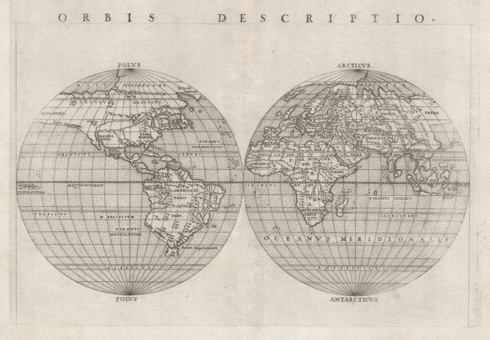
Orbis Descriptio
First Published
Venice, 1561
This Edition
1562, first state
Size
17.8 x 26.0 cms
Technique
Condition
very good
Price
This Item is Sold
Description
"Two important innovations were introduced by this edition into cartographical literature, or at least into the literature of atlases, viz:
1st. The division of the map of the world into two hemispheres, of which the right one represents the Old World and the left the New. As may be seen by the fac-simile pl. XLV, this map of Ruscelli is extremely well-designed, and engraved on copper with Italian taste and Italian skill. [...].
2nd. The drawing of the map of the Arctic regions, [...]."
(Nordenskjold).
"This map, the first in an Atlas to show the Old and New Worlds in separate hemispheres, was used by Ruscelli to illustrate his edition of Ptolemy's Geographia, first issued in 1561."
(Moreland & Bannister).
"There are two 'modern' world maps in Ruscelli's edition of Ptolemy's Geographia: a double-hemisphere map and a rectangular 'Carta Marina'. Both follow earlier maps - oval and rectangular - which had appeared in Gastaldi's Ptolemaic atlas of 1548.
The first world map, the 'Orbis Descriptio', is elegantly designed and engraved on copper with typical Italian taste and skill.
Separate double-hemispherical maps were no innovation but this is the first time that such a representation had been used in an atlas. The map is adapted from the oval projection used for Gastaldi's larger world map and is presented on what is known as Roger Bacon's circular projection - also used for Tramezzino's large world map of 1554.
No southern continent is shown [in the first state], and Ruscelli has clearly marked the broad mass of land joining Asia and America as 'Terra Incognita' and its coastline as 'Littus incognitum.'.
At one time it was thought that the printer Vincenzo Valgrisi was responsible for the engraving, but it is now thought more likely on stylistic grounds that it was carried out by the brothers Giulio and Livio Sanuto.
Ruscelli's double-orb map was reprinted in the subsequent editions of his work in 1562, 1564 (twice), and 1574. Nearly twenty-five years later the plate was amended by the addition of a southern continent and the two editions by Rosaccio in 1598 and 1599 contain this state 2 [the state here] in company with Rosaccio's own world map."
(Shirley).
"According to Nordenskiold, two important innovations were introduced by Ruscelli in his edition of Ptolemy's Geografia into cartographical literature, or at least into the literature of atlases, one being this map and its division of the map of the world into two hemispheres, of which the right one represents the Old World and the left the New. Nordenskiold describes this map as being 'extremely well designed, and engraved on copper with Italian taste and Italian skill.' "
(Suárez).
"Ruscelli's editions of Ptolemy included a Ptolemaic world map and a double-hemisphere 'modern' world map. This is the first printed double-hemisphere world map to appear in an atlas. Ruscelli translated the Ptolemies into Italian and had a new set of maps prepared. Various editions, from 1561 to 1599, contain many of the same maps with some alteration and additions in the final editions.
The double-hemisphere map shown here [in Manasek] is the first state, from the first (1561) edition. Later states include a New Guinea and a large antarctic continent. There are other minor changes, particularly among the islands.
Ruscelli's work also included a rectangular 'modern' world map, the so-called Mariners' Map."
(Manasek).
Spectacular world map with North America shown as part of further Asia. This theory long persisted and goes back as far as Columbus himself, who after four voyages was still convinced on his death bed in 1507 that America was east Asia and the islands in the West Indies lie off the coast of Asia, and Cuba should be identified with the 'Zipangri' or 'Zipangu' (Japan) reported in the Middle Ages by Marco Polo to be the easternmost island off the Chinese coast (the land where the sun rises). Note that Japan is not present on this map.
"Yet it is one of the ironies of history that the admiral himself died ignorant of what he had really accomplished, still insisting that he had discovered a large number of islands, a province of China, and an 'Other World' [Otro Mundo, the South American Continent]; but of the vast extent of that Other World, and of the ocean that lay between it and Asia, he had neither knowledge not suspicion."
(Morison).
Odd for the time of publication, [in the first state] there is no big Southern Continent and (therefore) Tierra del Fuego is correctly assumed to be an island [changed back in state 2 here], although this was not proven until 1616 (Schouten & LeMaire who sailed around Cape Hoorn) or suspected by Sir Francis Drake during his famous Circumnavigation of the world 1577-79, when blown far south by a storm after reaching the Pacific through Magellan's Strait. "The West Occidental [the Western Ocean] and the South Sea are but one!".
"'Golden Hind' anchored off Henderson Island [='False Cape Horn'] on 24 October 1578 and tarried until a new moon rose on 1 November. Master Fletcher went ashore with the Captain General, walked down the grassy slopes, found them thick with delicious wild currants, and on its southernmost point set up a stone and carved thereupon the date and the Queen's name. Drake later told Hawkins that he 'grovelled' - threw hinself on his belly - at the uttermost tip of this cape and stretched out his arms as far as he could toward the South Pole, so he could boast that no man had been so near it as himself. So typical of Drake - always something of the big boy in him."
(Morison).
Girolamo Ruscelli (1504-1566)
Girolamo Ruscelli (1504 Viterbo -1566 Venice), an Italian Alchemist, Physician and cartographer, was editor of a revised and expanded Italian edition of Ptolemy's 'Geographia', published as 'La Geografia di Claudio Tolomeo. The newly engraved maps were based, generally, on those compiled by Giacomo Gastaldi for the Venice miniature atlas edition of 1548.
Ruscelli's atlas was issued several times between 1561 and 1599 by the following publishers
- Venice, Vincenzo Valgrisi, 1561
- Venice, Vincenzo Valgrisi, 1562
- Venice, G. Zileti, 1564
- Venice, G. Zileti, 1574
- Venice, Heirs of Melchior Sessa, 1598-99
The Ruscelli and Gastaldi atlases were the most comprehensive atlases produced between Martin Waldseemüller's 'Geographia' of 1513, and Abraham Ortelius 'Theatrum' of 1570. The significance of the Gastaldi and Ruscelli atlases cannot be overestimated. They defined the known geography of the world for decades. These atlases also reintroduced the use of copper engraving into the service of cartography, which was dominated by woodcut printing after several not very succesful attempts to print from copper in the 15th century. The Gastaldi and Ruscelli atlases proved that maps could be beautifully engraved on copper. As it was a harder material than wood, it was harder to engrave but also gave the ability to render much more detail. The Gastaldi and Ruscelli atlases marked a turning point in the history of cartography, from then on the majority of cartographic works used this medium.
"Ruscelli was editor of a revised and expanded edition of Ptolemy's Geographia which was issued in Venice several times between 1561 and the end of the century.
The newly angraved maps were based, generally, on those compiled by Giacomo Gastaldi for the Venice edition of 1548."
(Moreland & Bannister).
Related Categories
Related Items


