Leen Helmink Antique Maps
Antique map of Italy by Ulm Ptolemy
The item below has been sold, but if you enter your email address we will notify you in case we have another example that is not yet listed or as soon as we receive another example.

Stock number: 18818
Zoom ImageCartographer(s)
Lienhart Holle / Nicolaus Germanus (biography)
Title
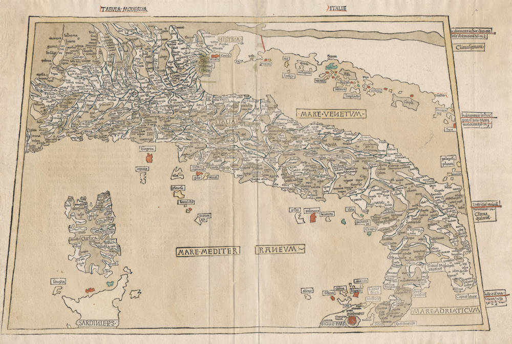
Tabula Moderna Italie
First Published
Ulm, 1482
This Edition
1486
Size
35.0 x 56.2 cms
Technique
Condition
mint
Price
This Item is Sold
Description
The first modern map of Italy. Very rare.
From the second 1486 edition of the celebrated Ulm Ptolemy of 1482, which was the first atlas printed outside Italy and the first atlas illustrated with woodcut maps.
This example in beautiful original color from the publisher. Mount Etna in Sicily is shown on fire with red flames. Pristine condition. A strong and even impression of the woodblock. Collector's example.
This is one of the 5 modern maps that had been added to the canonical set of 27 Ptolemy maps.
The maps were cut by Johannes of Armsheim, who signed the world map, and incorporated as his sign a backwards N (И) into the woodcut text on each map – as seen here in the name of the Mediterranean sea. Another important feature of the Ulm version of Ptolemy is the introduction of a publisher’s colouring upon the maps: a rich blue colour in the sea that was made using lapis lazuli. This was replaced with a soft brown colour in 1486, as is the case here.
NICOLAUS GERMANUS REDRAWS PTOLEMY
This map of Italy, with its chocolate-colored mountain ranges running through the Italian peninsula, along the Alpine borders, and through Dalmatia, is one of the tabulæ novæ or ‘new maps' which were added to editions of Ptolemy's Geographia in the late 15th century. It comes from an edition published in Ulm in 1482 which was prepared by Dominus Nicolaus Germanus, a Benedictine monk from Saxony.
'Donis' was already responsible for a dozen manuscript copies of the Geographia which served as the basis for some of the first printed versions, he may even have been the ‘Nicolo Todescho' who supervised the printing of Francesco Berlinghieri's version in rhymed Italian verses (it came out in Florence at about the same time as the Ulm Geographia). At any rate, Donis's Geographia was the first to be printed in Germany and the first in woodcut. He made his own improvements to Ptolemy's projections, and boasted a little in his dedicatory letter to Pope Paul II that he had built a kind of memorial to himself by providing readers with an instantly clear picture of the world. He took special care, he emphasized, in rendering details such as mountain ranges and islands.
He added new maps of Italy, Spain, Palestine, Gaul, and Scandinavia - the last, which showed Greenland, probably based on a map by the Danish cartographer Claudius Clausson, or Clavus. Despite Nicolaus Germanus's enlargement of Ptolemy's world, he omitted any reference to the recent Portuguese discoveries along the west coast of Africa.
Except for Italy, none of the tabulæ novæ has an explanatory text, though relevant notes from the traditional text are printed on the reverse of the other maps. The execution of the map of Italy is typical of the rest (coloring was added by hand). One, that of the world, is the first printed map signed by its engraver (who was Johann Schnitzer of Armsheim).
(Skelton)
Lienhart Holle / Nicolaus Germanus
"As far as cartography is concerned the printing of Ptolemy's Geographia at Ulm in 1482 (and 1486) - the first edition with woodcut maps - was an event of the greatest importance.
The edition of Ptolemy's Geographia printed at Ulm in 1482 was the first published outside Italy and the first with woodcut map; it contained 26 maps based on Ptolemy and six 'modern' maps"
(Moreland & Bannister)
"The first edition printed north of the Alps, and the first woodcut version, is more crudely executed than the previous (Ptolemy) productions. Nevertheless the bold Germanic style and the Gothic lettering have a distinctive decorative appeal, especially when combined with rich colouring. The printer was Leinhart Holle, also known for the publication of the illustrated book Buch der Weisheit.
Shortly after the publication Leinhart Holle went bankrupt. His stock was taken iover by Johann Reger who, four years later in 1486, put out a second printing of about 1000 copies. Within and between both editions variations occur in respect of the text and printed legends although the same basic blocks were used."
(Shirley)
"In 1482 Lienhart Holle in Ulm published a revised edition of Ptolemy's Geographia with the reworking of the Ptolemaic corpus by the cartographer Nicolaus Germanus Donis. The atlas included five additional "modern" maps: Italy, Spain, France, Scandinavia, and the Holy Land. The atlas would be the first book printed by Lienhart Holle, however, it would appear that the venture proved ruinously expensive and his business would go bankrupt shortly after publication. The remaining sheets, the woodblocks and the types passed to Johann Reger in Ulm, who reissued the work in 1486.
As well as the modern maps the atlas bears some other notable first. It was the first time that maps were signed by the artist responsible for the woodcutting; in this case Johannes of Armsheim, who signed the world map, and incorporated a backwards N into the woodcut text on each map. It is also the first to print the accompanying text on the verso of the map to which it refers."
(Skelton)


