Leen Helmink Antique Maps
Antique map of Holy Land by Ulm Ptolemy
The item below has been sold, but if you enter your email address we will notify you in case we have another example that is not yet listed or as soon as we receive another example.

Stock number: 18817
Zoom ImageCartographer(s)
Lienhart Holle / Nicolaus Germanus (biography)
Title
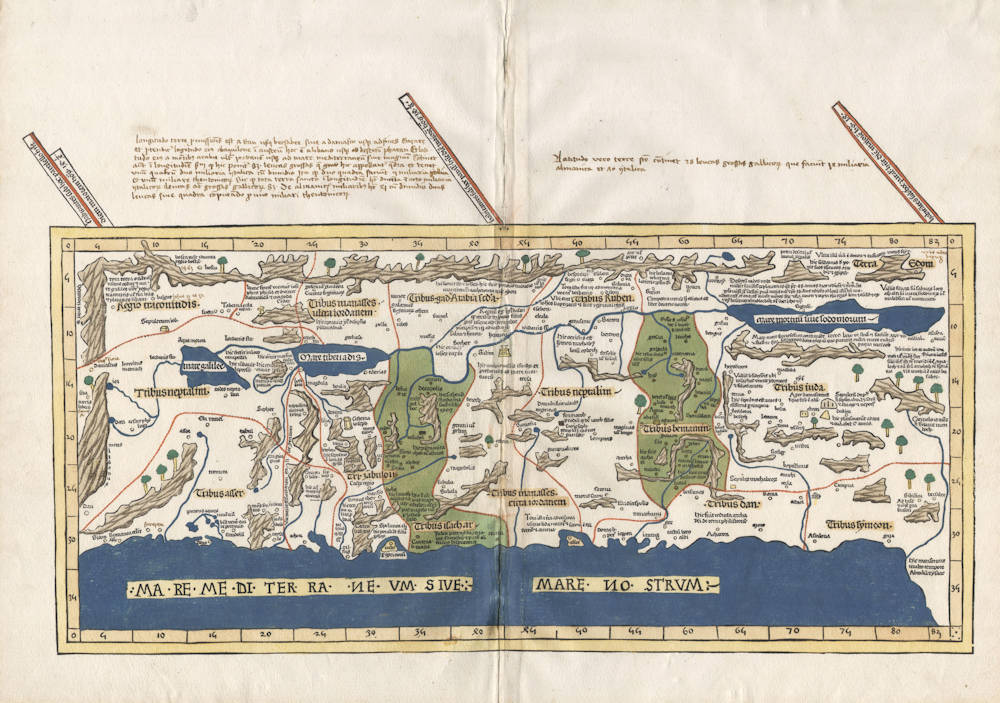
Tabula Moderna Terre Sancte
First Published
Ulm, 1482
This Edition
1482 first edition
Size
42.0 x 56.5 cms
Technique
Condition
mint
Price
This Item is Sold
Description
The first modern map of the Holy Land. Very rare.
The map is based on the manuscript map by the crusader Petrus (Pietro) Vesconte, for Marino Sanuto's Liber Secretorum Fidelibus de Crucis' of circa 1320, and updated by Donnus Nicholaus Germanaus in 1482. The map includes several notable improvements in the original Sanuto model, which are described in Nebenzahl.
The map is oriented to the southeast as indicated by the lines of latitude in the top margin.
“The map is orientated to the east, and shows the whole of Palestine on both sides of the Jordan divided into the 12 Tribes. The shore line runs from Sidon to Gaza. South of a fantasy Carmel Mountain there is a big island, called the Castle of the Pilgrims (Atlit of today), and a similar but smaller island north of Jaffa called Assur. The Carmel Mountain is misshapen. The Jordan River in its wide meanderings is shown as a thin line”
(Laor 603)
The 1482 maps were cut by Johannes of Armsheim, who signed the world map, and incorporated as his sign a backwards N (И) into the woodcut text on each map – as seen here in the name of the Mediterranean sea. Another important feature of this Ulm edition is the introduction of a publisher’s colouring upon the maps: a rich blue colour in the sea that was made using lapis lazuli, as is the case here. This was replaced with a soft brown colour in 1486.
First edition. From the celebrated Ulm Ptolemy of 1482. The first atlas printed outside Italy and the first atlas illustrated with woodcut maps.
Pristine condition. In beautiful original color from the publisher. Strong and even impression of the woodblock. Collector's copy.
This example with interesting contemporary manuscript annotations above the map.
The manuscript text in the upper left margin reads (modernized transcription):
"Longitudo Terrae Promissionis est a Dan usque Bersabee sive a Damasco usque ad fines Gazarae,|et protenditur longitudo eius ab aquilone in austrum, hoc est a Libano usque ad desertum Pharan. Et lati-|tudo eius a montibus Arabiae ultra Jordanem usque ad Mare Mediterraneum sive Magnum. Continet|autem in longitudine, secundum quod hic ponitur, 85 leucas grossas, quae hic appellantur quadra, et tenet|unum quadrum duo miliaria Italica cum dimidio. Ita quod duo quadra pariunt V miliaria Italica|et unum miliare Theutonicorum. Sic quod tota Terra Sancta in longitudine habet ducenta et octo miliaria|Italicorum, leucas aut grossas Gallicorum 85, de Almanicis miliaribus habet 41 cum dimidio, duas|leucas sive quadra computando pro uno miliari Theutonicorum."
"The length (longitude) of the Promised Land is from Dan to Bersabee or from Damascus to the borders of Gazara|and the longitude of it stretches from the north to the south, that is from [the] Lebanon [mountains] to the desert of Pharan. And the|width (latitude) of it [stretches] from the mountains of Arabia beyond the Jordanis (Jordan River) to the Meditterranean or Big Sea. It encompasses|further in length, as presented here, 85 leucae grossae (big leguas), here called quadra (squares) and one|quadrum contains two and a half Italian miles. So two quadra are equal to five Italian miles|and one mile of the Teutons (Germans). Therefore the Holy Land as a whole has in the length two hundred and eight Italian|miles or 85 leucae grossae (big leagues) of the Gauls (French), of German miles it has 41 and a half, if we count|two leagues or quadra for one mile of the Teutons."
The manuscript text in the upper right margin reads (modernized transcription):
"Latitudo vero Terrae Sanctae continet 28 leucas grossas Gallicorum, quae pariunt 14 miliaria|Almanica et 70 Italica."
"The width however of the Holy Land covers 28 leucae grossae (big leagues) of the Gauls, corresponding to 14 German miles and 70 Italian [miles]."
Lienhart Holle / Nicolaus Germanus
"As far as cartography is concerned the printing of Ptolemy's Geographia at Ulm in 1482 (and 1486) - the first edition with woodcut maps - was an event of the greatest importance.
The edition of Ptolemy's Geographia printed at Ulm in 1482 was the first published outside Italy and the first with woodcut map; it contained 26 maps based on Ptolemy and six 'modern' maps"
(Moreland & Bannister)
"The first edition printed north of the Alps, and the first woodcut version, is more crudely executed than the previous (Ptolemy) productions. Nevertheless the bold Germanic style and the Gothic lettering have a distinctive decorative appeal, especially when combined with rich colouring. The printer was Leinhart Holle, also known for the publication of the illustrated book Buch der Weisheit.
Shortly after the publication Leinhart Holle went bankrupt. His stock was taken iover by Johann Reger who, four years later in 1486, put out a second printing of about 1000 copies. Within and between both editions variations occur in respect of the text and printed legends although the same basic blocks were used."
(Shirley)
"In 1482 Lienhart Holle in Ulm published a revised edition of Ptolemy's Geographia with the reworking of the Ptolemaic corpus by the cartographer Nicolaus Germanus Donis. The atlas included five additional "modern" maps: Italy, Spain, France, Scandinavia, and the Holy Land. The atlas would be the first book printed by Lienhart Holle, however, it would appear that the venture proved ruinously expensive and his business would go bankrupt shortly after publication. The remaining sheets, the woodblocks and the types passed to Johann Reger in Ulm, who reissued the work in 1486.
As well as the modern maps the atlas bears some other notable first. It was the first time that maps were signed by the artist responsible for the woodcutting; in this case Johannes of Armsheim, who signed the world map, and incorporated a backwards N into the woodcut text on each map. It is also the first to print the accompanying text on the verso of the map to which it refers."
(Skelton)


