Leen Helmink Antique Maps
Antique map of Northern Atlantic by Ruscelli
The item below has been sold, but if you enter your email address we will notify you in case we have another example that is not yet listed or as soon as we receive another example.

Stock number: 18810
Zoom ImageCartographer(s)
Girolamo Ruscelli (biography)
Title
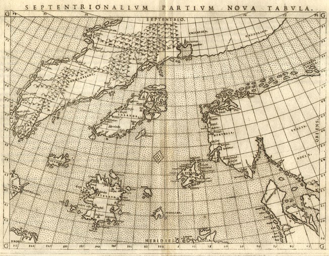
Septentrionalium Partium Nova Tabula
First Published
Venice, 1561
This Edition
1562 first state
Size
17.5 x 23.9 cms
Technique
Condition
excellent
Price
This Item is Sold
Description
Ruscelli's spectacular "Zeno" map of the North Atlantic after the map in a 1558 travel book about a (false?) voyage in 1380 to these areas by Nicolo and Antonio Zeno. The map introduces many new fictitious islands in great detail like "Frisland" (with 32 places and capes named!), "Deogeo", "Estotiland", "Estland", and the monastery of "S. Tomas" in Greenland. Many of these lovely products of imagination remained on maps for centuries, mainly because Gerard Mercator accepted it as authentic and adopted much of it in his famous large 1569 world map and his 1595 map of the North Pole. Ortelius in turn used the map as a prototype for his map of the North Atlantic. Frobisher and Davis accepted the map for their explorations in the 1570's and 1580's, respectively.
First state, first copperplate with the imprint of the copperplate running of the top of the sheet (in the first state the maps were printed two by two on one large copperplate, the sheets were then cut after printing. In the second state the copperplate is cut in two, resulting in a platemark also on top of the page. From 1574 onwards, a second pate is used).
Strong and even imprint of the copperplate. White paper, with wide margins all around. No restorations or imperfections. An excellent collector's example of this important map.
"In this map, the North Atlantic is littered with mythical islands, some traceable to the Zeno legend. In 1558 Marcolino published a book by Nicolo Zeno in which the "discovery" of several of these islands was noted. The book was allegedly a compilation of northern voyages by Zeno's ancestor made over a hundred years earlier. Zeno himself edited this map for Ruscelli's geography. The information on this map was used later by Ortelius in his map of the northern regions of the Atlantic.
Among the mythical islands shown, Frisland in particular had a long cartographic life. Many later maps continued to show it, some with exquisite detail and even locating its capitol city.
This map shows some famous cartographical misconceptions. Along with maps showing California as an island, the Prester John maps of Africa, the wonderful Schlaraffenland and perhaps the Kircher map of Atlantis, this map should be part of the backbone of an collection of maps of mythical geography."
(Manasek).
"Girolamo Ruscelli's edition of Ptolemy's Geography included newly engraved copperplates by Giulio and Livio Sanuto. This copperplate map is a reduced version of the Nicolo Zeno of 1558. The only noticeable cartographical difference is that there is no land bridge between Greenland and Scandinavia. On the Zeno it was designated 'Mare et terre incognita'.
This map is one of two that were angraved on the same plate, printed and then separated for the book. At least one example survives of the complete sheet, which tells us that in this case the sister map was the Ptolemy World. This can be seen in the atlas by the fact that the plate mark of the maps runs off the top of the page. The map appeared in the Latin edition of 1562, and both the Italian and Latin editions of 1564. In 1574 a new plate was used which lasted until the final edition of 1599. The difference between the two is purely typographical:
Plate 1 - 1561 Lower left DROGEO, and in the title SEPTENTRIONALIVM
Plate 2 - 1574 Lower left DEOGEO, and in the title SEPTENIRIONALIVM"
(Burden).
Girolamo Ruscelli (1504-1566)
Girolamo Ruscelli (1504 Viterbo -1566 Venice), an Italian Alchemist, Physician and cartographer, was editor of a revised and expanded Italian edition of Ptolemy's 'Geographia', published as 'La Geografia di Claudio Tolomeo. The newly engraved maps were based, generally, on those compiled by Giacomo Gastaldi for the Venice miniature atlas edition of 1548.
Ruscelli's atlas was issued several times between 1561 and 1599 by the following publishers
- Venice, Vincenzo Valgrisi, 1561
- Venice, Vincenzo Valgrisi, 1562
- Venice, G. Zileti, 1564
- Venice, G. Zileti, 1574
- Venice, Heirs of Melchior Sessa, 1598-99
The Ruscelli and Gastaldi atlases were the most comprehensive atlases produced between Martin Waldseemüller's 'Geographia' of 1513, and Abraham Ortelius 'Theatrum' of 1570. The significance of the Gastaldi and Ruscelli atlases cannot be overestimated. They defined the known geography of the world for decades. These atlases also reintroduced the use of copper engraving into the service of cartography, which was dominated by woodcut printing after several not very succesful attempts to print from copper in the 15th century. The Gastaldi and Ruscelli atlases proved that maps could be beautifully engraved on copper. As it was a harder material than wood, it was harder to engrave but also gave the ability to render much more detail. The Gastaldi and Ruscelli atlases marked a turning point in the history of cartography, from then on the majority of cartographic works used this medium.
"Ruscelli was editor of a revised and expanded edition of Ptolemy's Geographia which was issued in Venice several times between 1561 and the end of the century.
The newly angraved maps were based, generally, on those compiled by Giacomo Gastaldi for the Venice edition of 1548."
(Moreland & Bannister).


