Leen Helmink Antique Maps
Antique map of Maldives by Langenes
The item below has been sold, but if you enter your email address we will notify you in case we have another example that is not yet listed or as soon as we receive another example.

Stock number: 18789
Zoom ImageCartographer(s)
Barent Langenes (biography)
Title
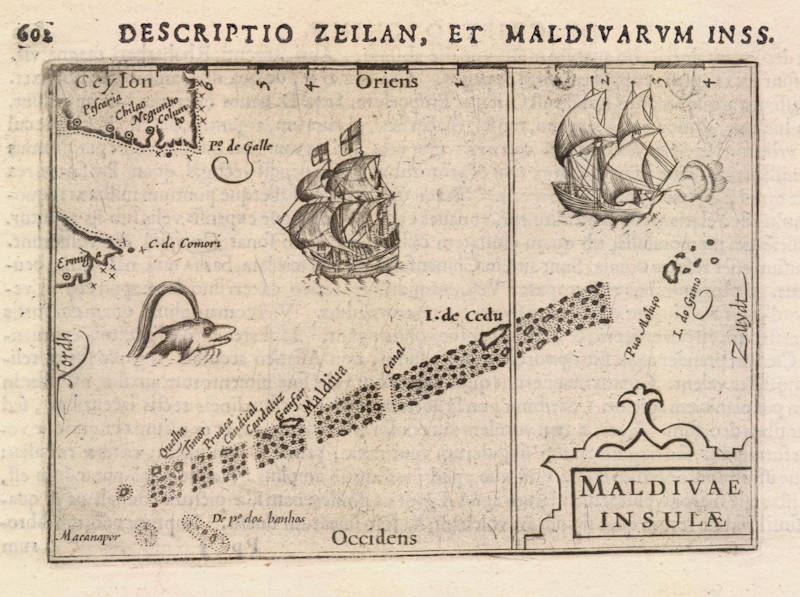
Maldivae Insulae
First Published
Middelburg, 1598
This Edition
1602
Size
8.5 x 12.3 cms
Technique
Condition
mint
Price
This Item is Sold
Description
Early pocket atlas map of India by Barent Langenes.
A milestone map for the region. The geographical content is largely derived from the 1596 Linschoten map of the Middle East and India.
Barent Langenes
Langenes was a publisher in Middelburg about whom little is known except that he produced the first edition of a very well known miniature atlas, the 'Caert-Thresoor'. The atlas was the work of Cornelis Claesz in Amsterdam, the foremost publisher of the day. The copperplates were engraved by brothers-in-law Jodocus Hondius and Petrus Kaerius, the most skilled engravers of the day.
The Caert-Thresoor
The Caert-Thresoor, a small atlas of the world in oblong format, appeared in 1598; thereby, its publishers wrote a new page in the history of atlas cartography. The preparations for this prototype of the new generation of Dutch pocket atlases began around 1595. At that time, Cornelis Claesz commissioned the skilled engravers Jodocus Hondius and Pieter van den Keere to engrave the maps. An unnamed young writer and poet - in Burger's opinion, it was Cornelis Taemsz of Hoorn - was called upon to write the accompanying text. Claesz wanted his Caert-Thresoor to outshine the similar small world atlases that had been produced thus far in Antwerp. In this way, he set out to spark interest in and knowledge of geography among the public at large in the Northern Netherlands. In view of the various reprints, editions, and adaptations of this work in Dutch, French, and Latin, obviously the Amsterdam publisher was quite successful in that endeavor.
Even prior to the publication of the little atlas, Cornelis Claesz used the maps that had been prepared in a number of his books, where they served as title vignettes and illustrations in the text. The earliest of these books dates from 1596. Ultimately, the Caert-Thresoor contained 169 maps, engraved in the superb and clear style of the brothers-in-law Hondius and Van den Keere. The text accompanying the maps runs over two volumes, comprising 462 respectively 196 numbered pages. The earliest known edition of the Caert-Thresoor bears the imprint of a printer from Middelburg, Barent Langenes, and indicates that the work was also available from Cornelis Claesz. However, Langenes should only be considered a co-publisher. Even though the dedication to the States of Zeeland bears his signature, he had apparently played only a temporary and minor part in the production process. The publication of the Caert-Thresoor required large, long term investment on the part of Cornelis Claesz, making the financial support and help of others very welcome. Indeed, the preface contains an ode in praise of the Caert-Thresoor and its publisher Cornelis Claesz, along with a note that he had been the driving force behind the project as well as its initiator. From the subsequent edition (1599) onward, only the Amsterdam imprint is given: Tot Amsterdam, By Cornelis Claes. opt water, int Schrijfboeck.
The pocket atlases that were produced in Antwerp remained to a large extent simplified smaller-scale versions of Ortelius's Theatrum Orbis Terrarum. Meanwhile, the Caert-Thresoor broke away from this folio atlas and conformed less strictly to the structure and layout of that atlas. Production of the Caert-Thresoor moved in a new direction by including much new material that had been collected in the 1590s in Amsterdam. This material was based partly on Portuguese information and knowledge, partly on that derived from Dutch voyages for trade or discovery. The revisions showed up mainly in the second book, which should be seen as a kind of up-to-date supplement. This part covers the non-European countries. Here one finds, among other things, detailed maps of the Philippines and the archipelago of the East Indies. The maps were taken directly from the map that Jan Huygen van Linschoten made in 1595. Only the map of Java was taken from Plancius's map of the Moluccas. The detailed maps of places in the Indian Ocean derive mainly from Van Linschoten's map of the northern Indian Ocean. The model for the bird's-eye view of Moçambique Island was the engraving in Van Linschoten's Itinerario (1596). Furthermore, the print showing the shipwreck of the Portuguese vessel the S. Jacobus on the shallows known as the Baixos de Iudia in the Strait of Moçambique was copied from Plancius's map of Southern Africa. Plancius's maps also served as models for other maps in the Caert-Thresoor. For example, the Canary Islands, the detailed map of Tercera, and the Cape Verde Islands were copied from them. The small map of Newfoundland is a section of Plancius's map of the North Atlantic Ocean. And the little map of the Strait of Magellan is an unaltered section of Van Linschoten's map of South America.
These are merely a few examples of the sources that were used. The fact that the publishers did not hesitate to use Plancius's and Van Linschoten's maps - in fact, they copied a great deal 'literally' without citing the authors' names - supports the assumption that the atlas was produced by someone very close to these sources. Did not Cornelis Claesz act as publisher for both Plancius and Van Linschoten after all? The last map that appears in the Caert-Thresoor shows the results of Jan Huygen van Linschoten's second voyage in search of a Northeast Passage. The map depicts the seven ships that sailed from Holland and had been in the Kara Sea in 1595. The accompanying text gives a brief report of the two first arctic voyages. In few words, the author reports that the third voyage had not yet been completed, the ship De Rijp had returned but the ship under the command of Willem Barentsz had not yet done so. This small map and the accompanying text were apparently added as the very latest news after the atlas was already complete. However, its value as a source of current information was apparently undermined by the long duration of the printing process for the Caert-Thresoor. Strangely enough, the atlas does not go any deeper into the results and adventures of the third voyage. This is striking, since the members of Barentsz's crew who survived had returned to Amsterdam in the autumn of 1597, while Langenes's dedication was not written till 20 May 1598.
The Caert-Thresoor enjoyed widespread interest, and commercially it did not do Cornelis Claesz any harm. Under his direction, editions appeared in Dutch (1598, 1599, and 1609), French (c.1600 and 1602), and Latin (1600, 1602/03, and 1606). But even after he died, the work still went through a number of editions at different publishing houses. From the Dutch edition of 1599 onward – influenced by the criticism of Paullus Merula - most of the maps were provided a latitude scale. In 1600, a French and a Latin edition appeared. Cornelis Claesz called upon Aelbert Hendricksz in The Hague to print the French edition on the basis of a translation by I. de la Haye, who was a rector and clergyman in Kampen. But for the Latin edition, the production again took place in Amsterdam, though this time in collaboration with a publisher in Arnhem, Jan Jansz. For that edition, the scholar Petrus Bertius (1565-1629) made a completely new geographical description of the whole world. Moreover, the maps then served as illustrations, unlike previous editions in which the text was meant to explain the maps. In 1609, the Caert-Thresoor appeared in a new Dutch version, prepared by the author and poet Jacobus Viverius (1571/72-c.1636). The starting point was the original base text taken from the earlier Dutch editions of 1598 and 1599, which were then partly revised in light of Petrus Montanus's text in Mercator's Atlas Minor (1607).
(Schilder)
THE CAERT-THRESOOR BY BARENT LANGENES AND CORNELIS CLAESZ.
The Caert-Thresoor of 1598 set a new standard for minor atlases. Scholars like Petrus Bertius and Jacobus Viverius edited the text. The small maps are extremely well engraved; they are neat and clear and elegantly composed. They served many purposes in other books published in Amsterdam. Their contents reflect the level of cartography in Amsterdam at the turn of the century, where up-to-date information on newly discovered regions was readily available. The Caert-Thresoor is a collection of maps to which the text was adapted and not the other way around as is the case with many geographical studies.
Its success must have prompted Jodocus Hondius to publish a reduced edition of Mercator's Atlas in 1607.
The first edition was published in 1598 by Barent Langenes, bookseller and publisher located in De Vier Winden in Middelburg (1597-1605). Little is known about Langenes, except that he published some travel descriptions. As is stated on the title page, the edition was also sold by Cornelis Claesz, in Amsterdam. All later editions were published by Claesz. and his successors.
However, in the "Ode", a laudatory poem in 11 strophes, only “Claessoon” is credited for the work. Moreover, in 1605 Paullus Merula wrote in his Cosmographia that Cornelis Claesz. had asked him eight years before to make a Latin translation of the Caert-Thresoor, which Claesz, had published in the Dutch language.
Merula complained that the maps were not only too small but that they also lacked indications of longitude and latitude (in the first 1598 edition issued by Langenes). Merula considered this kind of work useless. Translating the work of novices (“foetus novorum hominum”) into Latin was just a job and added nothing to his scholarly work. Claesz. persisted and asked Merula if he would write a complete new text after the co-ordinates were added to the maps. Merula conceded and would write a completely new text to the maps. Despite this agreement, Merula continued, Bertius had already translated and enlarged the text, which was quite satisfying for him.
Only nine copies of the 1598 first edition by Langenes are known.
(van der Krogt)


