Leen Helmink Antique Maps
Antique map of South East Asia by Wytfliet
The item below has been sold, but if you enter your email address we will notify you in case we have another example that is not yet listed or as soon as we receive another example.

Stock number: 18704
Zoom ImageCartographer(s)
Cornelis Wytfliet (biography)
Title
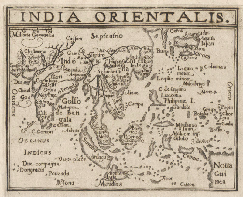
India Orientalis
First Published
Douai, 1605
This Edition
1605 first edition
Size
9.2 x 12.5 cms
Technique
Condition
excellent
Price
This Item is Sold
Description
Extremely rare overview map of the Far East, that only occurs in the last Wytfliet edition.
The geographical content is copied after the 1598 map by Barent Langenes of the same region.
Collector's item.
Cornelis Wytfliet (?-1597)
Little is known of Wytfliet except that he was a native of Brabant, but there is no doubt about the importance of his only atlas, which was the first one printed to deal exclusively with America.
Although its title indicated to be a 'supplement to Ptolemy', Part I covered the history of the discovery of America and its geography and natural history and Part II consisted entirely of the contemporary maps of America and a world map based on Mercator.
(Moreland & Bannister).
Descriptionis Ptolemaicae Augmentum
In 1597 Cornelis van Wytfliet published his Augmentum to Ptolemy's Geography. This is true in as much as it covers all the Americas, a part of the world unknown to the latter; however, no other connection between them exists. Dedicated to Philip III of Spain it is a history of the New World to date, recording its discovery, natural history etc. For the book Wytfliet had engraved nineteen maps, by whom we do not know, one of the world and eighteen regional maps of the Americas. Of these the following eight maps all relate to the north of the continent. As such this book can be truly called the first atlas of America. It was an immediate success and ran to several editions. Not much is known about Wytfliet other than that he was an advocate and secretary to the Council of Brabant, whose capital at the time was Louvain.
Despite the fact that this map covers territory virtually unknown to the Europeans, it owes its existence to the fact that Wytfliet showed every part of the continent however little knowledge there was of it.
(Burden).
THE ATLAS OF AMERICA BY CORNELIS VAN WYTFLIET
The Descriptionis Ptolemaicae Augmentum (“Augmentation to Ptolemy's description”) is the only known work by Cornelis van Wytfliet, secretary to the Council of Brabant, who died in 1597 (a more correct Dutch orthography of his name is “Van Wijtvliet”). He named his work an augmentation to Ptolemy's Geography because it covers the Americas, a part of the world unknown to Ptolemy. However, there is no other connection between the works of Ptolemy and Van Wytfliet.
His book includes 19 maps, a world map and 18 regional maps, all of which were specially engraved for this edition. It was the first separately published atlas with all the maps entirely devoted to America. Most of Van Wytfliet's maps are the first or among the earliest of specific regions of North and South America. The accompanying text describes the geography, natural history and ethnography. It provides a history of exploration and the voyages of Christopher Columbus (1492-1502), John Cabot (1497-98), Sebastian Cabot (1526-28), Francisco Pizarro (1527-35), Giovanni de Verrazzano (1524), Jacques Cartier (1540-42), and Martin Frobisher (1576-78).
Two editions of the Descriptionis Ptolemaicae were published at Leuven in 1597 and 1598 respectively by Jean Bogard and Gerard Rivius. Jean Bogard was publisher in Douai in France (1574-86 and 1598-1616) and Leuven (1586-98; however, it is possible that the Leuven publisher in this period was Jean's son Jean II Bogard). In 1603 the first Douai edition was issued by François Fabri, who continued issuing various editions with Latin and French texts. The last edition of Wytfliet’s book was published in Arnhem, where Jan Jansz. issued an edition with a French text in 1615.
(van der Krogt)
Related Categories
Related Items


