Leen Helmink Antique Maps
Antique map of the World by Münster


Stock number: 18649
Zoom ImageDescription
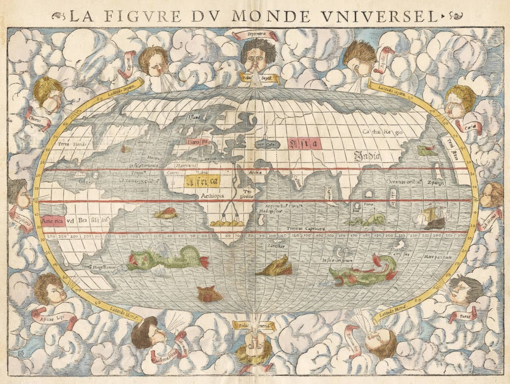
Münster's cornerstone map of the world. It is the most widespread and influential worldmap of the sixteenth century.
The map is a fascinating effort to amalgamate and reconcile the knowledge from classical antiquity (Ptolemy's Taprobana), the knowledge from medieval travelers (Marco Polo's Cathai Regio and Zipangri), with the latest discoveries by the Portuguese voyages (Calicut in India, the spice island of Gilolo, Corterati, Brasilij ins.) and the Spanish discoveries (Hispaniola, Cuba, Terra Florida).
The Pacific is based on Ferdinand Magellan's epic circumnavigation of 1519-1522, showing and naming the strait under South America (Fretum Magallianum)that led into the ocean named by him (Mare Pacificum). His flagship Victoria is prominently depicted crossing the Pacific. Northwest America is labelled Temistitan (Tenochtitlán, Mexico City), the capital of the Aztec empire that had been conquered by Hernán Cortés in 1521, at the very same time that Magellan's expedition was circumnavigating the world.
At the western edge, the map leaves open the possibility of an opening into the Pacific in central America, an old controversy going back to Columbus. At the eastern edge, the same possibility is rejected. It was not uncommon for cartographers to hedge their bets on contentious topics.
Like his predecessors Waldseemüller and Fries, Münster here rejects the idea of a large southern landmass, an old hypothesis from classical antiquity, popularized by Ptolemy's Geographica. Münster does show the only part of the Southland that had actually been seen by Magellan when he rounded South America, the Tierra del Fuego to the south of the Strait.
The oceans are adorned with sea monsters. Outside the map is a dramatic surround of clouds with twelve characteristic windheads representing the classical winds after Seneca blowing from each direction.
Condition
Early imprint of the woodblock, from the 1552 French edition of the Cosmographia. French title outside the map and on the back. Wide margins all around. Old unobtrusive repair to the lower centrefold, slightly affecting the windhead's breath, not affecting the map area, and almost invisible. Overall in excellent collector's condition, one of the best examples that we have seen.
Transcription and translation of the title
Title on verso:
LA FIGVRE DV MONDE VNIVERSEL PAR laquelle est monstré en quelz lieux la terre est descouuerte, & comme naturellement les trois principales parties, asçauoir Europe, Affricque & Asia: sont diuisees lune d'auec l'autre. Item quel lieu tiennent les isles neufues, qu'on appele Le nouueau monde. Le commencement du second liuvre te donnera plus ample expliication de toutes ces choses.
[The Image of the Whole World showing which places of the earth have been discovered, and how the three main parts of the world (Europe, Africa and Asia) are divided from each other. Item the location of the new isles, that are called the New World. The beginning of the second book will give you a fuller explication of all these things.]
Title on recto:
LA FIGVRE DV MONDE VNIVERSEL
[The Image of the Whole World].
The Mapping of the World
A NEW Woodcut world map was prepared for the 1550 edition of Sebastian Münster's Cosmographia to replace the map which had appeared in editions of the Geographia and Cosmographia from 1540 onwards. The publisher (from 1552) was Heinrich Petri, Münster's son-in-law.
The new world map is on an oval projection, similar in many respects to the previous map (Entry 77), but with the woodcutter's initials 'DK', identified as those of David Kandel, in the lower left-hand corner. The titles of the windheads are now in banners and the east and west winds (unlike the 1540 version) do not protrude inside the oval circumference. North America still retains its unusual shape almost bisected by water but the earlier note indicating a route to the Moluccas has been omitted.
This second world map of Münster was used for a large number of editions of the Cosmographia up to and including 1578 as follows:
1550 Latin and German
1552 Latin and French
1553 German
1554 Latin
1556 German and French
1558 German and Italian
1559 Latin
1560 French
1561 German
1564 French
1567 German
1568 French
1569 German
1571 Italian
1572 German and Latin
1574 German
1575 Italian
1578 German
The title of the map is usually printed outside the border at the top the language of the edition. All editions were published from Basle except the Italian editions of 1571 and 1575 which were from Venice and Cologne respectively, taken from the same block. Copies of the map may also be found in editions of Strabo's Rerum Geographicarum published at Basle in 1571.
The initials of the woodcutter (DK, for David Kandel) can be seen in the lower left-hand corner.
(Rodney Shirley Entry 92)
Sebastian Münster (1489-1552)
Following the various editions of Waldseemüller's maps, the names of three cartographers dominate the sixteenth century: Mercator, Ortelius and Münster, and of these three Münster probably had the widest influence in spreading geographical knowledge throughout Europe in the middle years of the century.
His Cosmographia, issued in 1544, contained not only the latest maps and views of many well-known cities, but included an encyclopaedic amount of detail about the known - and unknown - world and undoubtedly must have been one of the most widely read books of its time, going through nearly forty editions in six languages.
An eminent German mathematician and linguist, Münster became Professor of Hebrew at Heidelberg and later at Basle, where he settled in 1529. In 1528, following his first mapping of Germany, he appealed to German scholars to send him "descriptions, so that all Germany with its villages, towns, trades, etc. may be seen as in a mirror", even going so far as to give instructions on how they should "map" their own localities. The response was far greater than expected and such information was sent by foreigners as well as Germans so that, eventually, he was able to include many up-to-date, if not very accurate, maps in his atlases.
He was the first to provide a separate map of each of the four known Continents and the first separately printed map of England. His maps, printed from woodblocks, are now greatly valued by collectors. His two major works, the Geographia and the Cosmographia were published in Basle by his step-son, Henri Petri, who continued to issue many editions after Münster's death of the plague in 1552.
(Moreland & Bannister).
The remaining modern maps, [...], are all drawn on a plane projection, undergraduated, without scales, and variously oriented with north, south, east or west at the top, "without the excuse of topographical necessity", as Nordenskjöld severely remarks. In spite of these and other cartographic defects, they constitute an important corpus of geographical knowledge and interpretation; Münster was the first atlas-maker to furnish separate maps of the four continents then known; and for England, Scandinavia and southern Germany, eastern Europe and America he brought recent and significant representations into general currency.
(Skelton).
The Cosmographia of Sebastian Münster must rank as the greatest geographical compendium of the period - an immensely detailed work illustrated with woodcut portraits, scenes, town plans and panoramas, and maps. Born in 1488, Münster was a Fransiscan who became Professor of Hebrew at Heidelberg and later at Basle, where he taught Hebrew and, amongst other works, published the first German translation of the Bible from Hebrew. In 1540 his edition of Ptolemy's Geographia was published, followed in 1544 by the Cosmographia Universalis. Together these ran to over 35 editions published mostly in Basle in Latin, German, French and Italian versions. Münster's particular cartographic importance lies in the number of 'new' maps he introduced and, above all, in the innovative, separate mapping of each of the four continents. The map of the Americas is not only the first map to show the Western Hemisphere separately, but is also the first to show North and South America joined together.
(Potter p38).
Sebastian Münster was raised as a Franciscan monk, converted to Lutheranism, taught Hebrew at Heidelberg and Basle, and was proficient in Greek and some Asian tongues. He died of the plague in 1552. First published in 1540, his atlas was the first to contain separate maps of each of the four continents.
(Suárez).
In 1540 Sebastian Münster, who was to become one of the most influential cartographers in the sixteenth century, published his edition of Ptolemy's Geographia with a further section of modern, more up-to-date maps. He included for the first time a set of continental maps, the America was the earliest of any note. Münster studied Hebrew at Heidelberg and was a scholar of geography, writing amongst other works the Polyhistor.
He was one of the first to create space in the woodblock for the insertion of place-names in metal type. The map's inclusion in Münster's Cosmography, first published in 1544, sealed the fate of "America" as the name for the New World. The book proved to be very popular, there being nearly forty editions during the following 100 years.
(Burden).
Related Categories
Related Items


