Leen Helmink Antique Maps
Antique map of Australia, Far East by Pieter Goos
The item below has been sold, but if you enter your email address we will notify you in case we have another example that is not yet listed or as soon as we receive another example.
Stock number: 19879
Zoom ImageCartographer(s)
Pieter Goos (biography)
Title
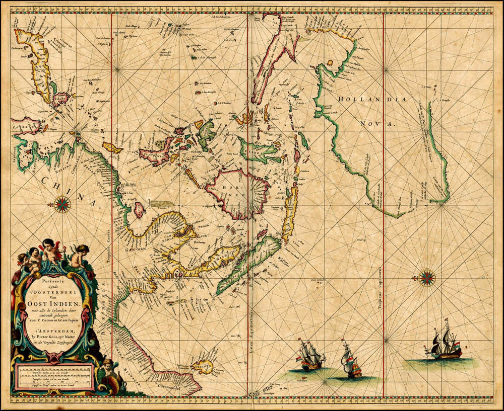
Pascaerte Zynde 't Oosterdeel van OOST INDIEN met alle de Eylanden daer ontrendt gelegen, van C. Comorin tot aen Iapan.
First Published
Amsterdam, 1666
Size
43.5 x 54.0 cms
Technique
Condition
excellent
Price
This Item is Sold
Description
One of the most desirable of all classic Dutch sea charts of the Far East and Australia, and of exceptional rarity.
This is Pieter Goos's celebrated sea chart of the eastern East Indies, one of the most decorative and sought-after Dutch charts of the region and an important early printed record of the Australian coast. As the title declares, it is the eastern portion of the East Indies, with all the islands lying thereabout, from Cape Comorin to Japan (t'Oosterdeel Van Oost Indien, met alle de Eylanden daer ontrendt geleegen van C. Comorin tot aen Iapan); with its western companion it formed the two-sheet coverage of the Indies in Goos's atlas. The chart extends from the coasts of Coromandel and Ceylon in the west, across the Bay of Bengal, Burma, Siam, and the South China Sea, to the China coast, Korea (Corea), and Japan in the north; the whole of the East Indian archipelago fills the centre (Sumatra, Java, Borneo, Celebes, the Moluccas, and the Philippines (Luçonia)) and to the south and east stretches the newly charted coast of Hollandia Nova, Australia.
The chart is constructed as a navigational instrument, on plane degrees, the sea covered with a fine web of rhumb lines radiating from compass rose and drawn as a working sea-chart. Pieter Goos (c. 1616-1675), an Amsterdam engraver, publisher, and chart-seller at the sign of the Gilded Sea-Mirror (in de Vergulde Zeespiegel), was among the foremost producers of sea-charts of his day; his Zee-Atlas of 1666 and the pilot-guide De Lichtende Columne were celebrated for the beauty of their charts, and this sheet is among the most admired of them.
The chart's lasting importance lies partly in its delineation of Australia, which assembles the Dutch discoveries of the preceding half-century. The legends record them in sequence: t'Landt de Eendracht ontdeckt A° 1616, the Eendracht Land of Dirk Hartog; I. de Edels Landt ontdeckt A° 1619; t'Landt van de Leuwin ontdeckt A° 1622, the Leeuwin's Land that still names the south-western cape; t'Landt van P. Nuyts, ontdeckt met t'Gulde Zeepaert van Middelburch, den 26 January A° 1627, the great southern coast traced by the Gulden Zeepaert; and G.F. de Wits Landt ontdeckt A° 1628, the de Witt's Land charted from the Vianen, which had been forced down the north-west coast after missing the monsoon window for the homeward passage through the Sunda Strait. To the north the Gulf of Carpentaria and Cape York are laid down from Jan Carstensz's voyage of 1623, with Arnhems Landt, Van Diemens Landt, and the rivers R. van Speult, R. Batavia, R. Coen, R. Nassau, and Staten R., the coast trailing off unjoined where exploration had ceased, so that whether New Guinea and the southern land were one remained an open question. Offshore are noted the wrecks and hazards that attended this coast, among them Houtmans Abrolhos, Dirck Hartog's Ree, and the Trial shoal where the English ship of that name was lost in 1622.
The chart is richly engraved and, in fine examples like here, vividly coloured: a large baroque title cartouche at the lower left is borne up by putti, a second cartouche holds the scales of Dutch, Spanish, English and French miles, and the seas are decorated with a compass rose and a fleet of Dutch East Indiamen under sail.
Pieter Goos (1616-1675)
Pieter Goos: A Master Cartographer of the Dutch Golden Age
Early Life and Background
Pieter Goos, born in 1616 in Amsterdam, was a significant figure in the cartographic history of the Netherlands during the early 17th century. He was the son of Abraham Goos (1590–1643), who was also a renowned cartographer, map seller, and engraver. Abraham Goos had worked in Antwerp before moving to Amsterdam, where he contributed to the vibrant cartographic scene by publishing maps and globes, often in collaboration with other notable figures like Jodocus Hondius and Johannes Janssonius. This familial background provided Pieter with a rich heritage in mapmaking, setting the stage for his own illustrious career.
Pieter's mother, Stijntgen Theunisdaughter de Ram, and his family connections, including his uncle Pieter van den Keere, further immersed him in a milieu where cartography was not just a profession but a family tradition and skill. Growing up in Amsterdam during the Dutch Golden Age, a time when the city was a bustling hub of commerce, art, and science, Pieter was exposed to the latest techniques in engraving, printing, and map production from a young age.
Career and Contributions
Pieter Goos began his career following in his father's footsteps, initially focusing on creating pilot books which were essential navigational aids for sailors. These books included detailed charts and instructions for navigation, particularly around the Mediterranean, which were crucial for the Dutch maritime trade that dominated the period. His early work was marked by a notarized agreement with Jacob Lootsman and Hendrick Doncker to publish these pilot books, ensuring their validity and distribution from 1643 to 1680.
In 1666, Pieter Goos made a significant leap in his career with the publication of his "De Zee-Atlas ofte Water-Wereld" (The Sea Atlas or Water World), which is considered one of the finest maritime atlases of its time. This atlas was not only a compilation of the latest navigational knowledge but also a work of art, featuring richly colored maps with detailed illustrations of ships, compass cards, and wind roses. The atlas was so well-regarded that it dominated the Dutch market until the 1670s, when the Van Keulen family began to rise in prominence.
Goos's maps were known for their accuracy and aesthetic appeal, with embellishments like large descriptive cartouches that added to their decorative value. His work was not limited to sea charts; he also ventured into mapping land areas, with his atlas "Atlas ofte Water-Weereld" being noted for its comprehensive coverage of the known world's coastlines. Goos was innovative in his approach, being the first to map Christmas Island, which he named "Mony" on his 1666 map of the East Indies.
Legacy and Influence
Pieter Goos's influence extended beyond his lifetime. His son, Henrik Goos, continued the family tradition in cartography and publishing, ensuring that the Goos name remained synonymous with quality mapmaking. After Pieter's death in 1675, his widow managed the business for a short period, maintaining the high standards set by Goos. The maps created by Goos were used well into the 18th century, showcasing the enduring value of his work. However, later evaluations pointed out some inaccuracies, particularly in the depiction of geographical features like sandbars and islands in areas like the Gulf of St. Lawrence.
Goos's work was not just functional; it was also a status symbol. His atlases were printed on thick paper, often with gilding, making them desirable items for decoration in homes and offices of the affluent. This dual purpose of utility and decoration reflects the broader trend in Dutch cartography of the time, where maps served both practical navigational needs and the aesthetic tastes of the wealthy.
Conclusion
Pieter Goos's life and work encapsulate the spirit of the Dutch Golden Age's cartographic achievements. His contributions to navigation through his detailed sea charts and atlases helped solidify Amsterdam's position as a center of mapmaking excellence. His legacy is one of precision, artistry, and innovation, with his maps being both tools for explorers and collectors' items that adorned the walls of the era's elite. Pieter Goos passed away in 1675, but his impact on the field of cartography is still recognized today, with his maps being sought after by collectors and historians for their historical significance and artistic beauty.
Related Categories
Related Items