Leen Helmink Antique Maps
Van Keulen's sea charts covering the eastern and central Indian Ocean
The item below has been sold, but if you enter your email address we will notify you in case we have another example that is not yet listed or as soon as we receive another example.

Stock number: 19729
Zoom ImageCartographer(s)
Johannes van Keulen II (biography)
Title
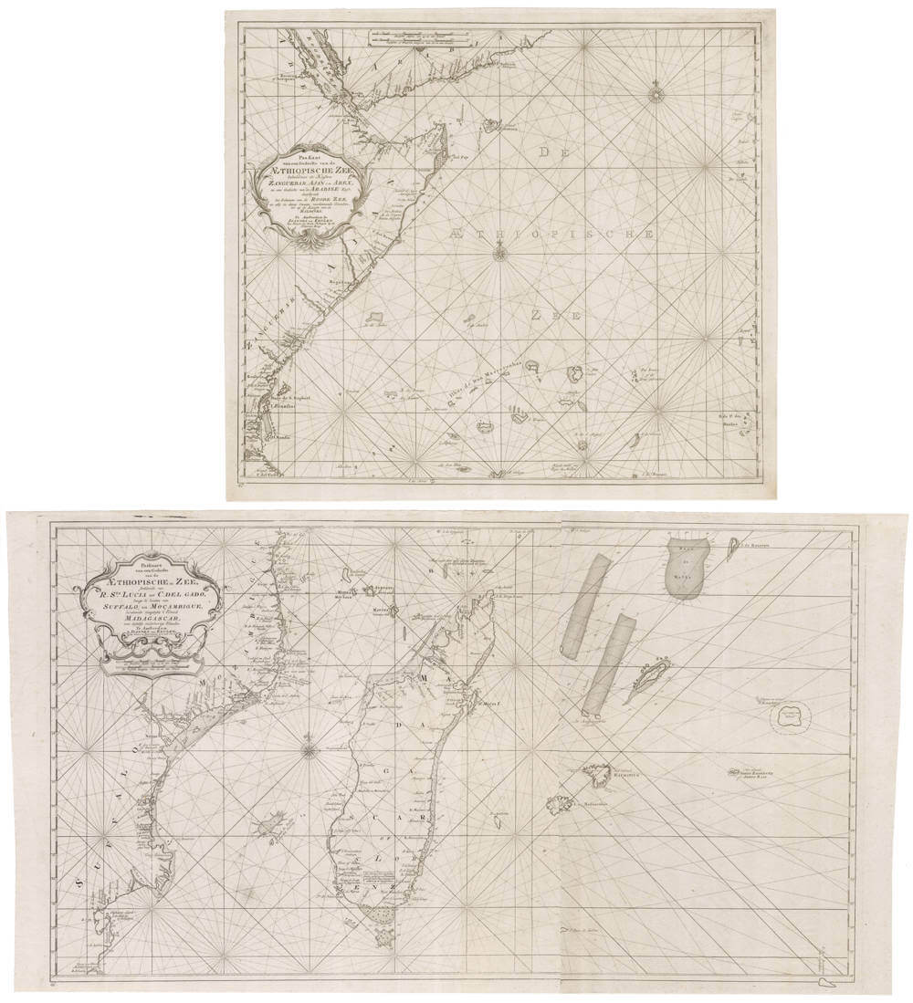
Paskaart van een Gedeelte van de AEthiopische Zee strekkende van R. Sta Lucia tot C. del Gado langs de kusten van Suffalo en Mocambique, bevattende insgelyks 't Eiland Madagascar, met desselfs onderhorige Eilanden.
First Published
Amsterdam, 1726
This Edition
1726-1755
Technique
Condition
excellent
Price
This Item is Sold
Description
Van Keulen's contiguous rare sea charts covering the eastern and central Indian Ocean (the "Aethiopean Sea").
The northern sea chart occurs only in the Zee-Fakkel Part VI, the 1753 secret atlas of the VOC.
It covers latitudes 18 degrees north to 10 degrees south, from the Red Sea to Cabo del Gado below Zanzibar, covering the northwest corner of the Indian Ocean, up to the Maldives in the east. It covers large swaths of islands and cliffs, including the island of Diego Garcia. This chart was of particular relevance to the VOC because of the coffee trade with the port of Mocha, or ships that would be on the way to Dutch Ceylon or Malabar. The chart measures 49.5x 57.5 cms, scale ca 1:6,000,000. The van Keulen cartography Appendix 6 (Zee Fakkel Part VI) chart 347 p 214.
The southern chart is of utmost rarity because it was only issued as a loose navigation chart.
It covers latitudes 9.5 degrees south to 28 degrees south, from Cabo del Gado in the north down to Rio de Santa Lucia in the south.
While a less wide version of the navigation chart is included in van Keulen's 1753 Part VI, the secret atlas of the VOC, the version here is the chart extended in the eastern direction that was issued as a loose chart between 1726-1755, that has a large eastern area appended to it, to cover the central Indian Ocean, including Reunion, Mauritius, Diego Rodriguez and St Brandao, as well as many reefs and shoals in the central Indian Ocean. In the west, the chart covers the African coasts from Suuthern Africa up to Mozambique. It shows all of Madagascar, as well as swaths of islands including the Seychelles. This extended chart is never in the market.
The extended chart measures 50 x 89 cms, scale ca 1:4,000,000. The van Keulen Cartography chart 346 p 214 (the non-extended version in the Secret Atlas) and the extended chart here Appendix 5 (Loose printed charts) chart 215.
Rarity
The northern chart is of utmost rarity, occurring in van Keulen's 1753 Secret Atlas of the VOC only. The southern extended chart is unobtainable and lacking in all collections, it was issued as a loose chart only between 1726 and 1755.
Condition description
Minor mending, strong imprints of the copperplates, wide margins, overall in excellent collector's condition.
Johannes van Keulen (1654-1711)
Gerard van Keulen (son) (1678-c.1727)
Johannes van Keulen II (grandson) (active 1726-1755)
The Dutch produced a remarkable number of enterprising and prolific map and chart makers but not even the Blaeu and Jansson establishments could rival the vigour of the van Keulen family whose business was founded in 1680 and continued under their name until 1823 and in other names until 1885 when it was from wound up and the stock dispersed at auction.
Throughout the history of the family, the widows several of the van Keulens played a major part, after their husbands' deaths, in maintaining the continuity of the business. The firm was founded by Johannes van Keulen who was registered as a bookseller in Amsterdam in 1678. In 1680 he published the first part of his 'Zee Atlas' which, over the years, was expanded to 5 volumes and continued in one form or another until 1734. More ambitious and with a far longer and more complicated life was his book of sea charts, the 'Zee-Fakkel', first published in 1681–82, which was still being printed round the year 1800. A major influence in the development of the firm was the acquisition in 1693 of the stock of a rival map publisher, Hendrik Doncker.
Although the firm was founded by Johannes van Keulen, he was primarily a publisher; it was his son, Gerard, a talented engraver, mathematician, Hydrographer to the East India Company, who became mainspring of the business which not only published charts but also books on every aspect of geograpy, navigation and nautical matters,
(Moreland and Bannister)
It was grandson Johannes van Keulen (II) who in 1753 produced Volume VI of the Zee-Fakkel for the VOC East Indiamen, containing printed charts for the navigation covering the waters from the Cape of Good Hope to Nagasaki . The atlas was not commercially sold and only for use on board of VOC ships, therefore it is also refered to as the 'secret atlas' odf the VOC. The engraving quality and craftmanship surpasses that of all earlier printed sea charts.
Sea charts from the secret atlas are among the rarest and most desirable sea charts for collectors.

