Leen Helmink Antique Maps
Famous superb title page by Jansson heirs
The item below has been sold, but if you enter your email address we will notify you in case we have another example that is not yet listed or as soon as we receive another example.

Stock number: 19411
Zoom ImageCartographer(s)
Johannes Janssonius (biography)
Title
Atlas Contractus
First Published
Amsterdam, 1666
Size
44 x 26 cms
Technique
Condition
very good
Price
This Item is Sold
Description
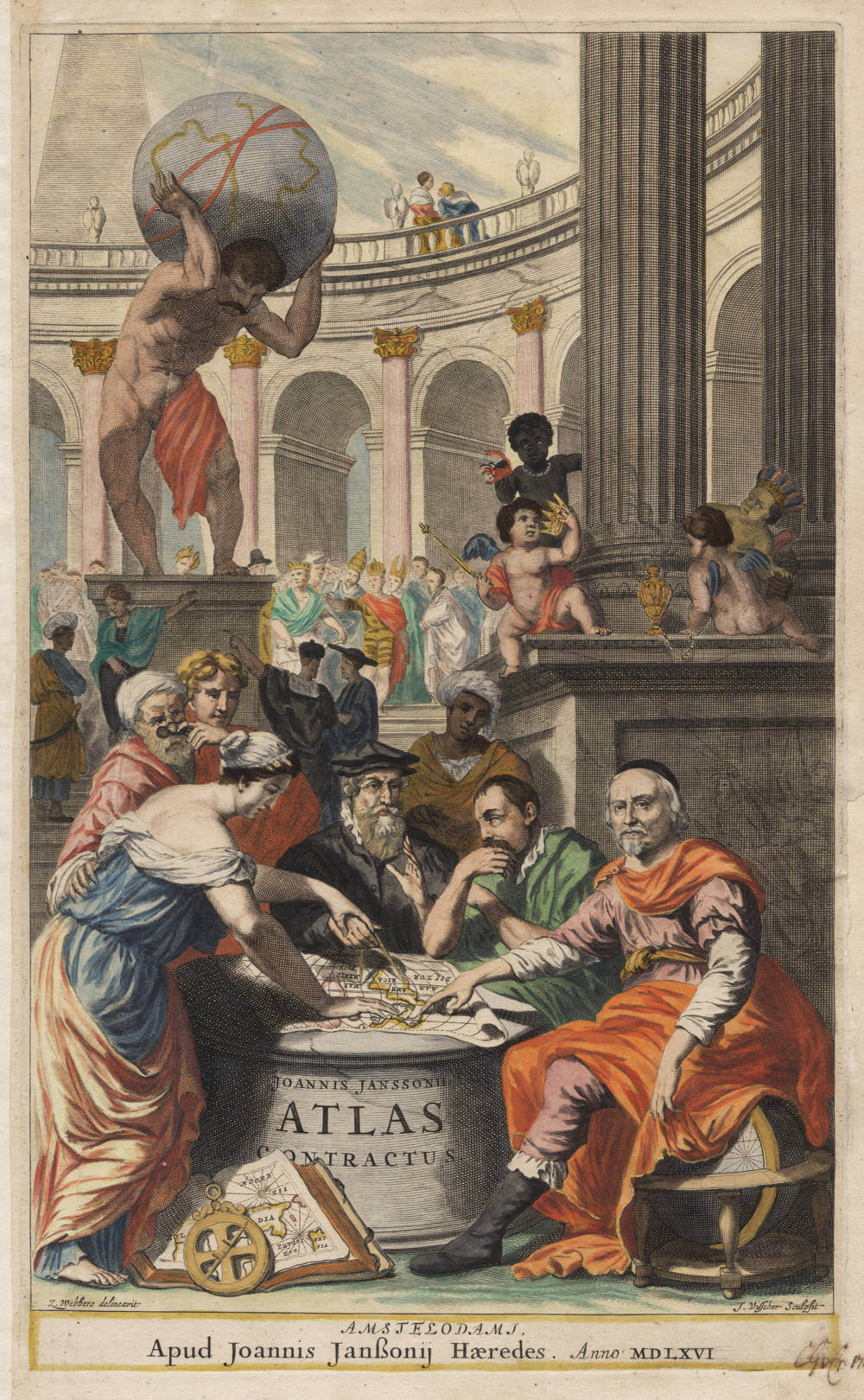
The rarest and most desirable of Dutch atlas title pages, in stunning original color and excellent condition.
After Janssonius' death in 1664 the running of his business passed to his heirs, Janssonius van Waes- bergen, who re-published several earlier atlases. One such work was the Atlas (or Atlantis) Contractus which has two striking post-1664 titlepages. Both are incorrectly dated MDLXVI (1556) at the foot instead of the equivalent for 1666.
The first titlepage for volume 1 of the Atlas Contractus is a pictorial composition showing a female figure representing Geography and several cartographers around a truncated columnar table. In the background is a large amphitheatre and, on a pedestal, Atlas supports the globe. At least three of the seated cartographers can be identified: in the centre is Gerard Mercator in a black flat cap, to the right Jodocus Hondius (Janssonius' father-in-law) and then on the very right is Joannes Janssonius himself with a black skull cap. He looks out of the picture directly at the viewer and with his right hand points to a map of America on the table. The other turbaned figures in the background are not identified for certain. The plate is signed by Zacharias Webbers as designer and by Joannes de Visscher as engraver in the lower left and right corners respectively.
(Shirley)
Johannes Janssonius (1588-1664)
Johannes Janssonius, more commonly known to us as Jan Jansson, was born in Arnhem where his father was a bookseller and publisher (Jan Janszoon the Elder). In 1612 he married the daughter of the cartographer and publisher Jodocus Hondius, and then set up in business in Amsterdam as a book publisher. In 1616 he published his first maps of France and Italy and from then onwards he produced a very large number of maps, perhaps not quite rivalling those of the Blaeu family but running a very close second in quantity and quality. From about 1630 to 1638 he was in partnership with his brother-in-law, Henricus Hondius, issuing further editions of the Mercator/Hondius atlases to which his name was added. On the death of Henricus he took over the business, expanding the atlas still further, until eventually he published an 11-volume "Atlas Major" on a scale similar to Blaeu's "Atlas Maior".
The first full edition of Jansson’s English County Maps was published in 1646 but some years earlier he issued a number of British maps in the Mercator/Hondius/ Jansson series of atlases (1636–44); the maps were printed from newly engraved plates and are different from the later 1646 issue and are now rarely seen. In general appearance Jansson’s maps are very similar to those of Blaeu and, in fact, were often copied from them, but they tend to be more flamboyant and, some think, more decorative.
After Jansson's death his heirs published a number of maps in an "Atlas Contractus" in 1666 and later still many of the plates of his British maps were acquired by Pieter Schenk and Gerard Valck, who published them again in 1683 as separate maps.
(Moreland and Bannister)


