Leen Helmink Antique Maps
Antique map of Western Australia by Philip Parker King
The item below has been sold, but if you enter your email address we will notify you in case we have another example that is not yet listed or as soon as we receive another example.

Stock number: 19339
Zoom ImageCartographer(s)
Philip Parker King (biography)
Title
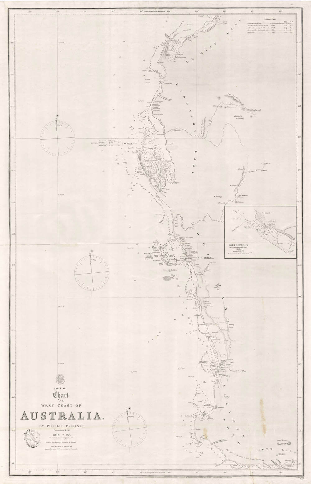
Sheet VIII of the West Coast of Australia
First Published
London, 1825
This Edition
1864
Size
82.0 x 52.0 cms
Technique
Condition
excellent
Price
This Item is Sold
Description
KING, Philip Parker, Rear Admiral
Sheet VIII. Chart of the West Coast of Australia by Philip P King Commander R.N. 1818-22 with additions by Commander Stokes 1842 and Septimus Roe Esq 1855. Sharks Bay by Captn Denham R.N. 1859.
520 x 820mm
London 1864
London. Published according to the Act of Parliament at the Hydrographical Office of the Admiralty 1st Aug 1825. Sold by J.D. Potter Agent for the Admiralty Charts 31 Poultry Street and 11 Kings St tower Hill, Corrections May 1864.
Exceptionally rare original copper engraved chart by Philip Parker King with later additions showing South West Australia from north of the Exmouth Gulf to east of King George Sound to Bald Island. Detailed inset of Port Gregory by A.C. Gregory Assist Survr. 1852.
Philip Parker King (1793-1856) was born on Norfolk Island. He entered the Navy in 1807. In 1817 he was put in charge of a Survey of the coasts of Australia. In the following five years he examined and drew large parts of its west, north, and north eastern coasts. He completed the work of Cook and Flinders and his name stands high among contributors to the mapping of the coasts of Australia. He returned to England in 1823. His charts were published by the Hydrographic office. Later in the Adventure accompanied by the Beagle, with Captain Fitzroy he surveyed the coasts of Patagonia.
The Hydrographic Office of the Admiralty was founded in 1795, Alexander Dalrymple who had been hydrographer to the East India Company was appointed its first director. Between 1797 and 1803 Captain Bligh of Bounty fame was employed as hydrographer, and took over direction during Dalrymple's illness. Capt. Thomas Hurd R.N. was in charge from 1808 to 1823, and during the latter part of his term made the official charts available to the Merchant Marine. He appointed George Thomas, a young man in his twenties, as Head Marine Surveyor. William Parry was Hydrographer from 1823-1829 and was succeeded by Admiral Sir Francis Beaufort 1829-55.
Condition
Excellent condition for a large chart that was issued separately. Here with seller's stamp in the lower left of Reading and Wellbank, 356 George Street, Chart and Nautical Book Sellers.
Reference
Tooley, R.V., "The Mapping of Australia and Antarctica', #808, pg 108
Philip Parker King (1791-1856)
King was born on Norfolk Island, to Philip Gidley King and Anna Josepha King née Coombe, and named after his father's mentor, Admiral Arthur Phillip (1738–1814), (first governor of New South Wales and founder of the British penal colony which later became the city of Sydney in Australia), which explains the difference in spelling of his and his father's first names. King was sent to England for education in 1796, and he joined the Royal Naval Academy, at Portsmouth, in county Hampshire, England in 1802. King entered the Royal Navy in 1807, where he was commissioned lieutenant in 1814.
King was assigned to survey the parts of the Australian coast not already examined by Royal Navy officer, Matthew Flinders, (who had already made three earlier exploratory voyages between 1791 and 1810, including the first circumnavigation of Australia) and made four voyages between December 1817 and April 1822. Amongst the 19-man crew were Allan Cunningham, a botanist, John Septimus Roe, later the first Surveyor-General of Western Australia, and the Aboriginal man, Bungaree. The first three trips were in the 76-tonne cutter HMS Mermaid, but the vessel was grounded in 1829.[citation needed] The Admiralty had instructed King to discover whether there was any river "likely to lead to an interior navigation into this great continent". The Colonial Office had given instructions to collect information about topography, fauna, timber, minerals, climate, and the Indigenous peoples and the prospects of developing trade with them.
From February to June 1818, the coast was surveyed as far as Van Diemen Gulf (between the Northern Territory and Timor) and there were many meetings with Aboriginal Australians and proas sailed by Makassans. In June the Mermaid visited Timor before returning to Sydney using the same route, arriving on 29 July.
In December 1818 and January 1819, King surveyed Macquarie Harbour in Van Diemen's Land (now Tasmania), sailing north in May 1819 for Torres Strait. King took John Oxley as far as the Hastings River on the Mid North Coast of New South Wales, and continued further up the coast to survey the coastline between Cape Wessel (Northern Territory) and Admiralty Gulf (Western Australia). King returned to Sydney on 12 January 1820.
On King's third voyage, Mermaid ran aground on the Queensland coast, but the crew did not realise how badly it had been damaged until they had rounded the tip of the Cape York Peninsula, sailed through the Torres Strait and across the northern coast as far as the Kimberley in Western Australia. When the ship was taking on water faster than it could be pumped out by the crew, King selected a spot 600 km (370 mi) north-east of present-day Broome, now known as Careening Bay, on Coronation Island, after he was forced to execute a manoeuvre known as careening, or deliberately grounding a ship so that it could be repaired. The crew did not meet any of the local Wunambal people while they were stranded there for 18 days doing the repairs, but they observed that the area was occupied, with Parker commenting in his journal on the dwellings that they observed. He described not only bark shelters on the beach, but more larger and more substantial buildings on top of the hill. He also observed the remnants of sago palm nuts, which were commonly eaten along the coast.
King was concerned at this point of the crew's vulnerability to the armed Makassan proas, as the Makassans harvested trepang (sea cucumbers) and traded along the northern Australian coast at that time, so he ordered the cannons to be mounted along the beach. They managed to repair the ship without incident and sailed away in early October 1820, but not before the ship's carpenter had been instructed to inscribe "Mermaid 1820" on an ancient boab tree, which still stands today.
King's fourth voyage was undertaken in the 154-tonne sloop HMS Bathurst. The ship headed north, through Torres Strait and to the north-west coast of the continent, including the Dampier Archipelago. Further survey of the west coast was made after a visit to Mauritius.
King had been promoted to commander in July 1821, and in April 1823 returned to England. He subsequently commanded the survey vessel HMS Adventure, and in company with HMS Beagle, spent five years surveying the complex convoluted coasts around the Strait of Magellan (1826–1830) at the southern tip of South America. At the same time, King put together a unique collection of Patagonian objects from local tribes living in Tierra del Fuego, which was later donated to the British Museum in London. In addition to written records, King also lent his hand to drawing and watercolour painting for illustrations, some of which were later used to illustrate his accounts. The result was presented at a meeting of the Royal Geographical Society in 1831. His eldest son, also named Philip Gidley King, accompanied his father and continued as a midshipman on HMS Beagle (1832–1836) on the continuing survey of Patagonia under Robert FitzRoy, in the company of noted scientist Charles Darwin (1809–1882). King owned a property at Dunheved in the western suburbs of Sydney where he entertained Charles Darwin on Darwin's last night in Sydney in January 1836.
King was appointed to the first New South Wales Legislative Council in 1829, however he was absent from the colony and did not take his seat, and was replaced by John Campbell. When King returned to the colony in 1832 he pressed for his reappointment to the council, however he was not re-appointed until February 1839. In April the same year King was appointed resident commissioner of the Australian Agricultural Company, a position he held for ten years. King offered to resign from the council on accepting this appointment, but his resignation was not accepted until October. King was again appointed to the Legislative Council in 1850, and was elected as the member for the Counties of Gloucester and Macquarie in 1851.
In 1855 King was promoted to Rear admiral on the retired list. King was a Fellow of the Royal Society.
King died on 26 February 1856 at North Sydney.
(Wikipedia)
Related Categories
Related Items


