Leen Helmink Antique Maps
Antique sea chart of Sunda Strait and Batavia by Samuel Dunn
The item below has been sold, but if you enter your email address we will notify you in case we have another example that is not yet listed or as soon as we receive another example.

Stock number: 19327
Zoom ImageCartographer(s)
Samuel Dunn (biography)
Title
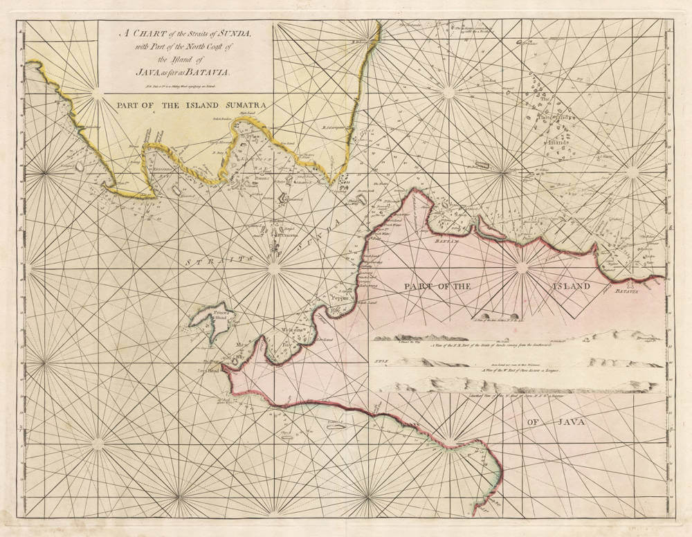
A Chart of the Straits of Sunda, with Part of the North Coast of the Island of Java, as far as Batavia
First Published
London, 1774
This Edition
London, 1795
Size
54 x 74 cms
Technique
Condition
excellent
Price
This Item is Sold
Description
Detailed sea chart of Sunda Strait, produced for the by Samuel Dunn, hydrographer and nautical teacher and examiner of pilots for the English East India Company (EEIC) from 1774 until 1794.
The chart includes countless depth soundings, safe anchorages, and coastal profiles.
Because Dunn's sea charts for the EEIC were produced as loose charts for company use, and not for regulasr sea atlases, they are of utmost rarity nowadays.
Condition
Printed on thick double layer paper, for use at sea. Very wide margins. A dark and even imprint from the copper plate. Elegant original pink and yellow wash colour. Excellent collector's condition.
Samuel Dunn (1723-1794)
Samuel Dunn was born in 1723 in Crediton, Devonshire, England. His early years were marked by an inclination towards mathematics and teaching. Despite his young age, he was actively teaching writing, accounts, navigation, and other mathematical sciences by the time he was 20 years old.
Dunn was a multifaceted individual, primarily known for his work as a teacher of mathematics, navigation, and astronomy. He began his teaching career early, running his own school by the age of 19. In 1758, he became the master of an academy at Ormond House, Chelsea, London, which was equipped with a good observatory.
As an inventor, he is noted for creating the "universal planispheres," which were large stereographic maps with a transparent index, facilitating the study of geography, astronomy, and navigation. He published an account of their description and use in 1759.
Dunn's observations and discoveries were significant. He observed a comet in January 1760 and communicated other discoveries to the Royal Society. His published works, particularly in the fields of astronomy, geography, and navigation, were numerous and influential. These included the "New Atlas of the Mundane System" in 1774, consisting of 62 copperplate engravings, and various works published under the auspices of the East India Company, where he served as a mathematical and nautical examiner for navigators from 1774 onwards.
Samuel Dunn's later life saw him residing in various locations in London, eventually settling at 1 Boar's Head Court, Fleet Street, where he lived until his death in January 1794. His will, interestingly, mentioned a bequest to ensure the teaching of navigation and mathematics in Crediton, reflecting his lifelong commitment to education.
Dunn was not a fellow of the Royal Society but contributed papers to its Philosophical Transactions. He also was a member of the Philosophical Society at Philadelphia, America.


