Leen Helmink Antique Maps
Antique map of Western Australia by Walker
The item below has been sold, but if you enter your email address we will notify you in case we have another example that is not yet listed or as soon as we receive another example.

Stock number: 19315
Zoom ImageCartographer(s)
Walker
Title
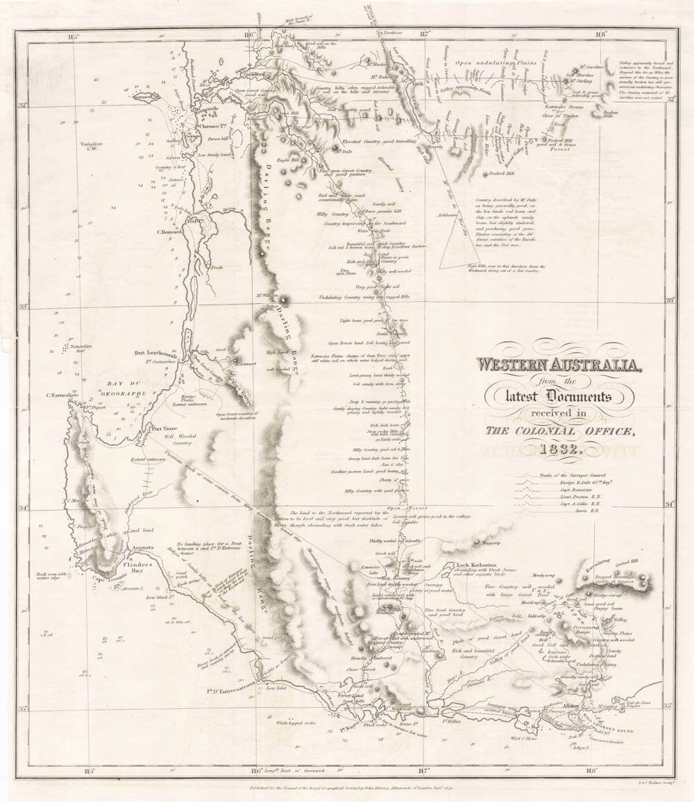
Western Australia from the Latest Documents Received in the Colonial Office 1832
First Published
London, 1832
This Edition
1832 first and only edition
Size
37.4 x 32.6 cms
Technique
Condition
mint
Price
This Item is Sold
Description
The first inland survey of Western Australia and the foundation map of the new colony.
Summary
This map of the Swan River and surrounds is the first published map of the proposed new settlement. Based directly on the survey work conducted by Stirling in 1827, it was presented to the British and Irish Parliament along with parliamentary papers in the hope that it would convince the Crown to establish a colony in Western Australia. The accompanying letter signed 4 November, 1828 by Thomas Peel, Francis Vincent, Edward Schenley and T. Potter Macqueen argued to the Crown the importance of establishing such a settlement. It was on the strength of this submission and Stirling's own reports and map that the Crown finally agreed to settle the Swan River.
(Simon Dewez}
WALKER, J&C 1832
WESTERN AUSTRALIA, / from the / Latest Documents/received in / The Colonial Office, / 1832.
Published for the Journal of the Royal Geographical Society by John Murray Albemarle S't. London Sept'r 1832 (bottom middle). J&C Walker sculp't. (bottom r.h.s).
37.4 x 32.6 cms
Fine uncoloured condition. Published in volume 1 of the second form of the Journal of the Royal Geographical Society', London 1832.
Map of the south-western part of Western Australia showing the tracks and sightings of the most recent explorations and settlements in the new colony.
J and C Walker's map of Western Australia was published just three years after the state became a separate colony in 1829. This was a time of rapid change for Western Australia. John Septimus Roe had been appointed as first Surveyor-General in 1829 (a post he held until 1871) and had commenced his survey work of the Swan River settlement. Other inland exploration had begun in earnest especially in the south-western corner. Fremantle Harbour had been selected as the settlement's port and by 1832, some twenty or so inland exploratory expeditions had been undertaken in the region.
By the end of the first three years of settlement, a handful of papers discussing all aspects of the emerging colony had been presented to the House of Commons and to the newly formed Royal Geographical Society. As well the Royal Geographical Society, formed in 1830, had itself published its first journal in 1831. Then in 1832, the format of the journal was altered somewhat and the first volume of the new series was produced. Most of these papers and journals contained one or more maps detailing the colony of Swan River. This map, drawn and engraved by the Walkers, was published in 1832 in the first volume of the new series of the R.G.S. journal. As such, it is one of the very earliest maps to show the newly formed colony at Swan River, being published one year earlier than the better known maps by John Arrowsmith and Joseph Cross. Furthermore, the Walker's map names Perth and Fremantle, only the second published map to do so. Walker's own map published one year before in the R.G.S. journal of 1831 claims the honour of being the first to show the new colony's two major settlements.
The R.G.S. map details all the recent exploration carried out to date in the Swan River noting the tracks and discoveries by explorers such as the Surveyor-General John Septimus Roe, Ensign R. Dale, Captains Bannister, Currie and Collie and Lieutenant Preston. The map has numerous annotations describing in quite some detail, the suitability of the newly discovered lands for agriculture and grazing. Phrases such as 'rich and beautiful country', 'valley of good land', 'rich dark loam' and 'poor land thickly wooded' give clear indication of how important it was for the young colony to quickly identify good arable, productive land and to establish farming self sufficiency.
Not in Tooley.
(Simon Dewez' description of this very same copy of the map)


