Leen Helmink Antique Maps
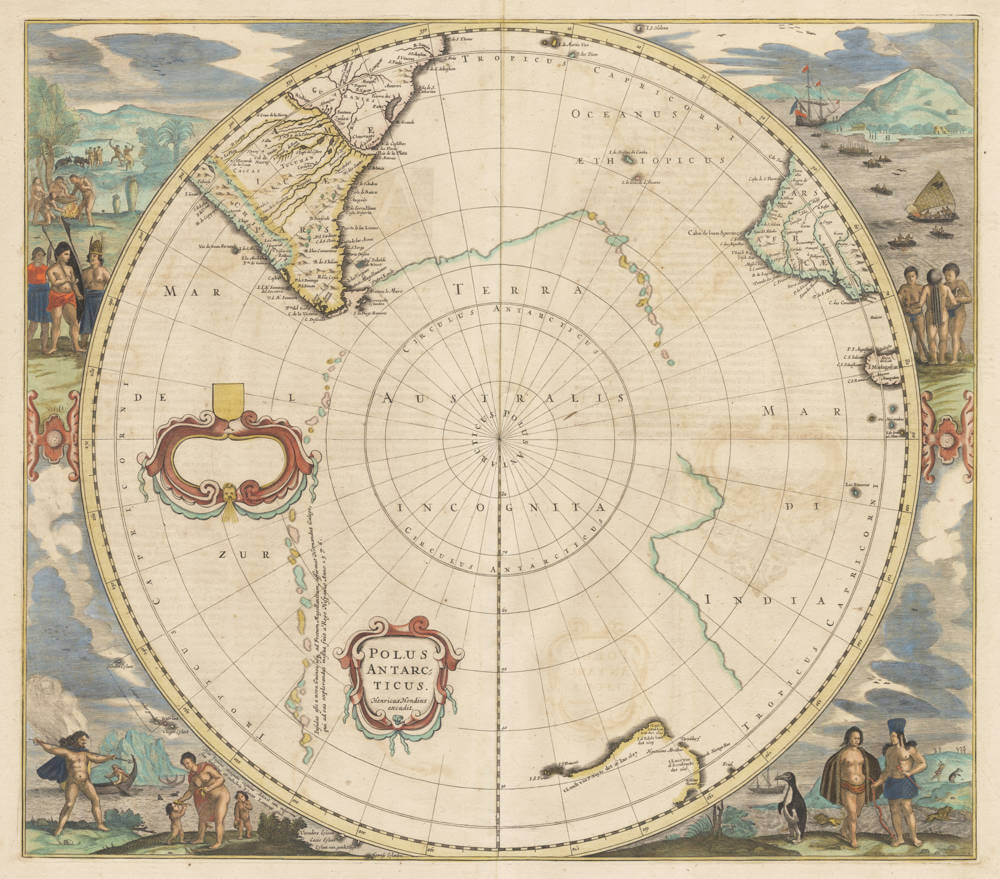
Antique map of South Pole by Henricus Hondius

Stock number: 19303
Zoom ImageCartographer(s)
Henricus Hondius (biography)
Title
Polus Antarcticus
First Published
Amsterdam, 1637
This Edition
1639-49 French edition
Size
44.0 x 49.5 cms
Technique
Condition
excellent
Price
$ 2,500.00
(Convert price to other currencies)
Description
Seminal early map of the region, with spectacular border decorations.
Australia Unveiled
This was the most widely disseminated map of the pre-Tasman period. The title appears within a cartouche in the bottom left quarter of the map. Another, blank cartouche is found to the left of the centre. POLUS ANTARCTICUS is one of the earliest maps on which the discoveries of Pieter Nuyts on the south coast of Australia in the year 1627 are shown. On the west and the south coast of Australia the following names appear:
Trial
Willems Revier
t Lant van d'Eendracht
det 1616
Dirck Hartogs Ree
Houtmans Abrolhos
Tortelduyf
I. d'Edels lant det 1619
t Lant vand Leeuwin
det 1622
't Landt van P. Nuyts
det 26 Ian 1627
I.S. Francois
I.S. Pieter
The map went through a number of editions and the copper plate was altered in all three times:
[State 2] in 1645 the name Hondius was replaced by that of Janssonius
[State 3] in 1650 the blank cartouche disappeared, and
[State 4] in 1657 the cartouche with the title disappeared, and Tasman's discoveries in Tasmania and New Zealand were inserted.
Source: Le Nouveau Theatre du Monde ou Nouvel Atlas. Tome Troisieme. Sumptibus et typis aeneis Henrici Hondij, Amsterodami 1639. fol. ttttt.
(Schilder).
Collecting Antique Maps
Originally issued by Henricus Hondius in 1641, this copperplate underwent various alterations during its sixty-year life. The first issue has a titlepiece which is changed in 1645 by the addition of Jansson's name in place of Hondius's. In 1657 title and publisher's imprint are removed to make way for the insertion of the coastlines of New Zealand and Tasmania after Tasman's voyage of 1642. Later editions, by the Wit about 1680, and Valck and Schenk 1700, may be found.
It is notable that by this period the uncertainty surrounding the existence of a great southern continent is such that not only are suggested coastlines broken, but also they are indicated by faint lines rather than the confident outlines employed by earlier map makers.
(Potter).
The mapping of Terra Australis
An important and popular pre-Tasman hemisphere map, the plate was re-engraved and used by three other publishers over sixty years to chart the additions made by Tasman's discoveries. Indeed, one of the earliest printed maps to show these was the 1650 edition by Jansson.
(Clancy).
The Printed World
HONDIUS, Hendrik
POLUS ANTARCTICUS. Henricus Hondius Excudit. 1637
49.0 x 43.0 cms.
Original color: Very light age toning to the paper. Some light browning showing through from the decorative cartouche on the verso. Otherwise a fine, even print published in the French edition of Jansson's ‘Gerardi Mercatoris et I.Hondii Appendix Novi Atlantis...’ in the Latin edition of September 1637.
One of only four maps published prior to 1640 to show the Pieter Nuyts discoveries along the south coast of Australia.
Up until 1627, the knowledge of Australian coastlines was restricted to largely haphazard contacts and sightings on the western and northern coasts. The eastern and southern coasts were completely unknown. There are extant records of a sighting along the southern coast in 1627, by a Dutch ship 't Gulden Zeepaard (the Golden Seahorse). The first time these discoveries appear on a printed map is on Gerritsz' 1628 map of Australia. Along the southern coast is written the description "’t Landt van P.Nuyts, opgedaen met 't Gulden Zeepardt van Middelburgh 26 Januarij A'o 1627". Given the accuracy of the map’s depiction of the coastline, the vessel must have come within sight of the coast. Nuyts was a senior official in the Dutch East India Company (V.O.C.) and it is his name that is always associated with the 't Gulden Zeepaerdt’s discoveries, however credit must also be given to the captain Frans Thyssen. The two islands of the south coast S.Francois and S.Pieter, were named after the Christian names of the two men. Perhaps Nuyts was the commander of the voyage. Apart from Gerritsz' map, only two other excessively rare maps published before Hondius' 1637 map, detail the Nuyts discoveries (and it is not absolutely certain whether they were in fact published before 1637).
These two maps by Colom and Theunis Jacobsz are known only in one or two copies (Schilder maps 42 and 43).
In the first state, Hondius' Polus Antarcticus (which was based on the geography from Gerritsz' 1628 map) is one of the earliest maps to show the discoveries of Pieter Nuyts. It fails however, to show the Dutch discoveries on Cape York Peninsula as the physical limits of the map do not extend far enough north. Hondius persists with the notion of Terra Australis Incognita, although he gives it rather indecisive boundaries. He charts a string of islands ‘Hernandus Galego’ is purported to have discovered in 1576. Although stated on the map that Hernando Gallego (chief pilot on Mendana's first voyage) first sighted these islands in 1576, they are in all probability no more than the remnants of the coasting of Terra Australis Incognita.
Hondius' map records many of the early Dutch discoveries in Australia, including those of Hartog in 1616, the Leeuwin in 1622, and ‘Nuyts’ in 1627. Noted also is ‘Houtman's Abrollos’, referring to Houtman's 1619 exploits. ‘Trial’ (the Trial Islands) are labelled as well as ‘I.S.Pieter’ island and ‘I.S.Francois’ off the eastern most part of Australia's south coast. Not noted are the discoveries made by de Witt in 1628. These discoveries remain unrecorded until the fourth and final edition of the map (see cat.32).
Hondius' map features decorative vignettes in each of the corners, with figures representing the various races of people. Hondius' Polus Antarcticus was one of the most popular pre-Tasman maps. In all, the copper plate was altered three times. In the 1644 edition, Tasman's discoveries are changed to Jansson. In the 1650 blank cartouche was removed and in 1652 the title cartouche disappears and Tasman's imprint was shown. There is no geographical change whatsoever between the first and second states, however in Jansson’s third state, ‘Tierra del Fogo’ is now tentatively charted as an island while parts of the coastline depicting Terra Australis Incognita and Gallego's islands have been reduced in size.
(Simon Dewez)
Two text legends in the Southern Pacific
Between the two cartouches:
Transcription:
"Infulas esse a nova Guinea usq. ad Fretum Magellanicum, affirmat Hernandus Galego, qui ad eas explorandas missus fuit a Rege Hispaniae Anno 1576."
Translation:
These islands extend from New Guinea to the Strait of Magellan, as stated by Hernando Gallego, who was sent to explore them by the King of Spain in the year 1576.
The text refers to Hernando Gallego's claim regarding the extent of the islands and his exploration mission commissioned by the Spanish King in 1576.
Lower left, just outside the map circle:
Transcription:
"Has Insulas suis sumptibus nunquam cognitas detexit tam memorab. iss. nauclerus & explorator Iac. Lemaireus 1618"
Translation:
These islands, never known before and discovered at his own expense, were revealed by the most memorable navigator and explorer Jacob Lemaire in 1618.
This text indicates that the islands were discovered by the navigator Jacob LeMaire in 1618 and had not been known prior to his expedition.
Rarity
The first state is of exceptional rarity, rarer than all later states.
Significance
The Polus Antarcticus map is a pivotal map in the history of southern hemisphere exploration.
As Clancy notes, it is the first serial map to depict the Antarctic region, while Tooley describes it as the best map prior to Tasman’s discoveries. The map was initially issued in four updated states, the series chronicles the increasing Dutch geographic knowledge from 1616 to 1644.
Condition description
First state of five. Attractive original colour. Mild mellowing of the paper. Overall in excellent condition. A very desirable collector's copy.
Jodocus Hondius (1563-1612)
Jodocus Hondius II (son) (1594-1629)
Henricus Hondius (son) (1597-1651)
Jodocus Hondius the Elder, one of the most notable engravers of his time, is known for his work in association with many of the cartographers and publishers prominent at the end of the sixteenth and the beginning of the seventeenth century.
A native of Flanders, he grew up in Ghent, apprenticed as an instrument and globe maker and map engraver. In 1584, to escape the religious troubles sweeping the Low Countries at that time, he fled to London where he spent some years before finally settling in Amsterdam about 1593. In the London period he came into contact with the leading scientists and geographers of the day and engraved maps in The Mariner's Mirrour, the English edition of Waghenaer's Sea Atlas, as well as others with Pieter van den Keere, his brother-in-law. No doubt his temporary exile in London stood him in good stead, earning him an international reputation, for it could have been no accident that Speed chose Hondius to engrave the plates for the maps in The Theatre of the Empire of Great Britaine in the years between 1605 and 1610.
In 1604 Hondius bought the plates of Mercator's Atlas which, in spite of its excellence, had not competed successfully with the continuing demand for the Ortelius Theatrum Orbis Terrarum. To meet this competition Hondius added about 40 maps to Mercator's original number and from 1606 published enlarged editions in many languages, still under Mercator's name but with his own name as publisher. These atlases have become known as the Mercator/ Hondius series. The following year the maps were re-engraved in miniature form and issued as a pocket Atlas Minor.
After the death of Jodocus Hondius the Elder in 1612, work on the two atlases, folio and miniature, was carried on by his widow and sons, Jodocus II and Henricus, and eventually in conjunction with Jan Jansson in Amsterdam. In all, from 1606 onwards, nearly 50 editions with increasing numbers of maps with texts in the main European languages were printed.
(Moreland and Bannister)
Related Categories
Related Items


