Leen Helmink Antique Maps
First map of Sunda Strait
The item below has been sold, but if you enter your email address we will notify you in case we have another example that is not yet listed or as soon as we receive another example.

Stock number: 19243
Zoom ImageCartographer(s)
Lucas Janszoon Waghenaer (biography)
Title
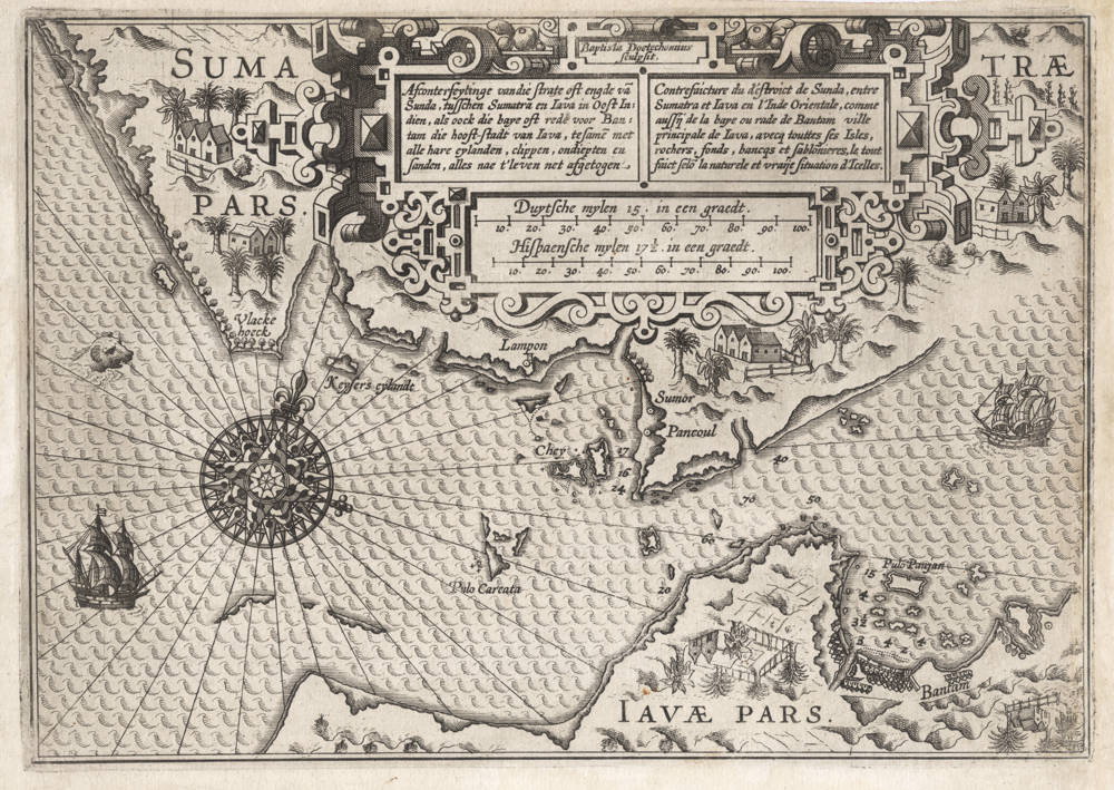
Afconterfeytinge van die strate oft engde van Sunda, tusschen Sumatra en Iava in Oost Indien
First Published
Amsterdam, 1602
Size
18.5 x 26 cms
Technique
Condition
excellent
Price
This Item is Sold
Description
The unobtainable first chart of Sunda Strait, a map of utmost significance that is lacking in every collection.
Full title
Afconterfeytinge van die strate oft engde van Sunda, tusschen Sumatra en Iava in Oost Indien, als oock die baye oft rede voor Bantam die hooft-stadt van Iava, tesamen met alle hare eylanden, clippen, ondiepten en sanden, alles nae t' leven net afgetogen.
Baptista Doetechomius sculpsit.
Dutch miles 15 in a degree.
Spanish miles 17½ in a degree.
Depiction of the strait or narrow of Sunda, between Sumatra and Java in the East Indies, including the bay or roadstead of Bantam the capital of Java, together with all of her islands, cliffs, shoals and sands, all drawn truthfully after life.
Copper engraved by Baptista van Doetecum
Dutch nautical miles of 15 in a degree of latitude.
Spanish nautical miles of 17½ in a degree of latitude.
Title set in an elaborate strapwork cartouche, in Dutch and in French text, with two scalebars below. Decorative compass rose on the left, showing that the chart's orientation. Two Dutch merchant three-master ships, to the west and east of the strait, and a sea monster. Palm trees and pepper plantations shown on both sides of the strait.
Enter the Dutch
The dreams and labours of Petrus Plancius and Jan Huyghen van Linschoten culminated in the Dutch First Fleet to the Indies taking place from 1595 to 1597. It was instrumental in the opening up of the Indonesian spice trade to the merchants that would soon form the United Dutch East India Company (VOC). This famous pioneering voyage, commanded by Cornelis de Houtman, would abruptly end the Portuguese Empire's trade monopoly for the East and it would dramatically change the Indian Ocean theatre, notably the balance of power and the rules of trade. Right from this first voyage onward, the Dutch were going to dominate the East Indies and its trade for more than 350 years.
Instead of following the established Portuguese sailing route from Europe to the Indies, Dutch fleets would follow Jan Huyghen van Linschoten's and Petrus Plancius' novel proposal to enter the Indonesian Archipelago through tiny Sunda Strait to get to the spice port of Bantam and to the Spice Islands much further to the east.
The advantages were multifold
- It was faster than the coastal monsoon routes that the Portuguese used sailing along the western and northern shores of the Indian Ocean
- It was healthier for the crew
- It minimized unnecessary naval skirmishes with the Portuguese and their allies along the coasts of Africa and Asia, and avoided altogether the Strait of Malacca that was controlled by the Portuguese
The major disadvantage was however that it required state of the art navigational instruments and skills, because coming from the Cape of Good Hope and hitting tiny Sunda Strait is like hitting a fly on a far away wall. In addition, the Strait is cluttered with countless little islands and shoals and has strong currents and unpredictable winds.
Using the latest ocean crossing guides like Michiel Coignet's Art of Navigation, and aided by centuries of European navigation experience, the Dutch fleets were succesful in mastering the route from the earliest voyages onwards.
Geographical importance of the chart
The navigation chart includes the Strait, the volcanic islands of Krakatao, the southern coasts of Sumatra, and the northwestern coasts of Java, and uses Waghenaer's new technique to superimpose coastal profiles on the coasts itself, for ease of use when approaching a coast (note that as a result, the profiles on Java are drawn upside down and pilots would turn the chart around when approaching Bantam). The chart prominently shows the pepper port of the Sultanate of Bantam, with precise fathem depth soundings in Bantam Bay and the roadstead, in the Strait and along the south coast of Sumatra. Keysers eylandt is the place where, during the first Dutch Fleet of 1595-97, Pieter Dirkszoon Keyser died, the chief pilot of the first Dutch fleet, who is famous for being the first to map and name the new found constellations of the southern hemisphere. For this purpose, he had been carefully trained in mathematics and astronomy by Petrus Plancius.
The map clearly illustrates the strategic location of Bantam as key to the rest of the archipelago. Initially, by conquering Malacca, the Portuguese controlled the traditional northern sea route between east and west, a situation that did not remain unchallenged. Both the Sultanate of Atjeh in northern Sumatra and the Sultanate of Johore in the southern Malaysian peninsula, opposed the Portuguese presence and it was only because of the perpetual enmity between these states that the Portuguese could uphold their position in Malacca. The port of Bantam occupied a favourable location near Sunda Straits, especially after the Dutch had opened up this southern sea strait between east and west, a route that had been proposed by Petrus Plancius and Jan Huyghen van Linschoten. The city was the foremost depot for pepper trade and profited from the increased demand for spices after the Dutch first fleet of 1595-97 and the Dutch fleets since.
Timing of the chart and significance for the European discovery of Australia
The chart was engraved in 1601-1602. Unbeknown to the publisher and to the engraver of the chart (because of the long travel times), a small Dutch fleet of five ships under the command of admiral Wolfert Harmenszoon (three merchant ships and two yachts including the legendary Duyfken, the very same ship that would establish the first European contact with Australia in 1606) was ambushed in Bantam Bay by a formidable Portuguese armada of 30 war ships commanded by admiral Andrea Portado de Mendoça. Surprisingly, the unequal weeklong battle (Dec 26, 1601 - Jan 1, 1602) ended with a Dutch victory, demonstrating the vulnerability of the Portuguese colonial empire in the Far East, which had been considered invincible throughout the 16th century. The Battle of Bantam marked the beginning of Dutch domination in Asia. This triumph decisively breaks the Portuguese hegemony and initiates the broad expansion of Dutch trade and dominion in the Far East. When Harmenszoon returns to the roadstead of Bantam on January 3rd, he is received with warm welcome and respect.
The fleet continues its course for Ternate and Banda, where Harmensz signs treaties with the local rulers who commit to sell their spices exclusively to the Dutch. Of the five sails in the fleet, only three return to the Republic. Duyfken, as a smaller (and faster) yacht is the first to return in the Netherlands on February 17, 1603, being the first to bring the news of the Bantam battle. The VOC had been founded in 1602 while this fleet was overseas, after this battle but before the fleet or the news of the battle had reached Holland in 1603. Little Dove was bought November 8th, 1603 by the new VOC company, for the reasonable price of 2200 Guilders. The Gentlemen XVII had decided to buy a number of small yachts for the company, provided the price was fair.
The new VOC company, that was founded in 1602 in the Netherlands while this Dutch fleet was in the Indies, would soon select Bantam to set up their head quarters and prime trading post for Asia. The VOC head quarters would stay there until 1619, when it was moved to Jacatra (Jakarta), a small port further east which they fortified and renamed Batavia.
Lucas Janszoon Waghenaer
Lucas Janszoon Waghenaer of the port of Enkhuizen in North Holland is legendary for his groundbreaking pilot books of European navigation, which served as a guide for other such books for more than 200 years. His name "Waggoner" became synonymous for any subsequent pilot books.
He was an experienced and able seafarer and pilot himself, with highest level theoretical as well as practical knowledge.
His first publication, Spieghel der zeevaert ("Mariner's mirror"), appeared in 1584. This chart-book combined an atlas of nautical charts and sailing directions with instructions for navigation on the western and north-western coastal waters of Europe. It was published in Dutch, German, Latin and English. The 1588 English edition is famous for being of great use in the naval battle with the Spanish Armada.
In 1592, his second pilot book, Thresoor der zeevaert ("Treasure of navigation"), was published.
In 1602, an expanded edition appeared that contained this first chart dedicated to Sunda Strait.
Rarity
The map and the Thresoor edition where it is published are unobtainable. Koeman records only two institutional examples of this edition: the Rotterdam Maritime Museum; and University Library Amsterdam.
Condition
Strong and even imprint of the copperplate. Right margin added, with unobtrusive reinstatement of the neatline. No loss of map content. Overall an excellent example of a map that is of utmost importance while so rare that it is lacking in every collection.
Sailing for the East
The cartography ogf the VOC in the early years
The voyage from the Republic to the East Indies and the navigation of the Asiatic waters themselves demanded that the ships were equipped with cutting edge maps and navigational aids. Cartographic developments had been gaining momentum even before the founding of the VOC.
In 1602 Lucas Janszoon Waghenaer's Thresoor der Zee-vaert - a pilot guide which up until then covered only the navigation of the Western European coasts - received an appendix entitled Verclaringhe van die Oost-Indische zeevaert, ghedaen int Jaer 1600 [Explanation of the East Indian Navigation of the year 1600]. This account was accompanied by a chart of Sunda Straits.
(Günter Schilder)
Monumenta Cartographica Neerlandica Vol VII
Lucas Janszoon Waghenaer's Theresoor der Zee-vaert (1592)
Around 1601, the copperplates of the Thresoor were already so worn that they had to be replaced. Cornelis Claesz had copies engraved, using examples of the original plates. The task was assigned to Benjamin Wright, Josua van den Ende, and members of the Van Doetecum family.
In 1602, a Dutch edition was published, with these words added to the title: '[...] once more the author added certain means to assist in sailing to various places in the East- and West Indies, with his notes, figures and coastal profiles'.
Indeed, this edition includes a 12-page appendix with sailing instructions and coastal profiles regarding the Western Indies. The appendix is accompanied by a map engraved by Baptista van Doetecum, a 'Verclaringhe van die Oost-Indische zeevaert, ghedaen int Jaer 1600' (that is, the voyage of Jacob Cornelisz van Neck and Wijbrant Warwijck) with a chart of the Sunda Strait by the same engraver, and a page on the variation of the magnetic compass. Waghenaer's 1602 edition of his Thresoor shows the first Dutch attempts to break into the Portuguese Empire in the east (the spice trade) and to penetrate the Spanish Empire in the west (the trade in salt).
(Günter Schilder)
Early Mapping of Southeast Asia
Lucas Janszoon Waghenaer and the Transition to Printed Sea Charts and Pilot Books
In the latter part of the sixteenth century, increasing trade within European waters led to an escalating demand for navigational charts. Although as early as about 1539 a Venetian mapmaker, Giovanni Vavassore, sold a sea chart intended for actual onboard. use, which was printed by woodblock, the printed medium was not commonly exploited for navigational charts until the end of the century. A Dutch pilot by the name of Lucas Janszoon Waghenaer recognized that a market existed for mass-produced sea charts, and so created the printed rutter, or mariner's guide with a full set of sea-charts for a particular region. First published in 1583, it covered the coasts of western Europe. Waghenaer's splendid charts -like many of their manuscript progenitors - tended to exaggerate important features along the coast, a quirk frequently noted about maps of Asian origin as well.
Although the work was a success among academics, pilots found its large format impractical, and so in 1592, Waghenaer introduced a new sea-atlas on a smaller oblong format. Like the earlier work this atlas, the Thresoor der Zeevaerdt, was conceived for use within European waters. But, reflecting the widening outlook of Dutch pilots, it also included information on the tracks between China and Japan which Linschoten had obtained from his friend, Dirck Gerritsz.
In May of 1598, a fleet of eight ships under Jacob van Neck and Wybrand van Warwijck left Texel for Southeast Asia, approaching the Indies through the Sunda Strait and establishing contact with the Javanese markets at Banten. Exploring Java, they continued on to Banda, Ambon, and the Moluccas, where they established what were known then as 'factories'. Factories were strongholds which would collect merchandise between the visits of Company vessels, thus avoiding the scarcity and high prices that a sudden demand would create. Descended from the fondachi, houses maintained by Genoese and Venetian merchants in North African and Middle Eastern ports, the first factory in Southeast Asia had been built by the Portuguese in Ternate. Van Neck's factories became the foundation of the Dutch spice trade.
Van Neck returned in July of 1599 with a bounty of pepper from Banten. Unlike the de Houtman voyage, this expedition was a commercial windfall, and so provided a strong incentive to lure other Dutch fortune-seekers to the Indies. It provided an inspiration for the English as well, proving as it did that defying the Iberian monopoly in the Indies trade could be richly rewarded.
Acknowledging the newly invigorated interest in the region and the accompanying need for navigational aids, Waghenaer tapped the van Neck voyage to add a chart of the Sunda Strait region to the Thresoor in 1602 (the chart offered here). That Waghenaer would include such a chart in what was essentially a pilot-guide to European seas reflects the fact that Holland was buzzing with fever for the Southeast Asian spice trade. Waghenaer's chart was a brilliant production, presenting for the first time a detailed, large-scale chart of a strategic parcel of Southeast Asian coasts. The chart was impressively accurate for the day, despite its imperfections, and was engraved with Waghenaer's usual finesse and elegance.
Early Dutch voyages such as those of de Houtman and van Neck, which braved the Sunda Strait to avoid the Portuguese stranglehold on Malacca, sailed eastwards after clearing the strait to the north. They skirted the emporiums along the northern coast of Java, and headed directly for the Moluccas and other important spice markets. As a result, Waghenaer had insufficient data to chart the coast of Sumatra north of the strait, which veers erroneously to the northeast (the upper right-hand corner of the map), rather than due north.
Waghenaer, however, thought like a chart-maker serving the needs of sailors, rather than the publisher of static maps. He treated his charts as inherently imperfect, evolving creations. By drawing Sumatra's eastern shores with less definition than other coasts, he indicated, in his own map-jargon, his relative uncertainty here. Secondly, once his sources confirmed that the information he provided was indeed faulty, he deleted it. The inaccuracy of the chart's southeast Sumatran coastline must have been confirmed within a few years after the map's initial publication in 1602, as by 1609 those shores (upper right on the map) had been erased from the plate. Such meticulous attention and updating stands in great contrast to the stagnation which dominated Dutch published maps for much of the seventeenth century.
The prominent cape at the lower center of the chart is the northwest tip of Java. This cape forms the western shoulder of the large bay of Banten, the great spice mart of Java and a focal point of the earliest Dutch voyages. Soundings are marked in the bay, as well as along the tricky neck at the northern end of the strait and the waters approaching it. The Sumatran port of Sumor, at about the center of the map on the west side of the cape, is still the name of a town (Sumur) on the east side of the cape, and the large island at the mouth of Banten's bay, Waghenaer's Pulo Panjan, is still known as Pulau Panjang. In the strait itself, Pulo Carcata represents the first mapping of Krakatau by its modern name. Krakatau, the active volcanic island whose eruption in 1883 was the most violent in modern days, became well-known to European sailors; in 1681 a V.O.C. vessel under Elias Hesse sailed close to Krakatau and reported desolate charred forests with smoke visible for many miles, the devastation of the eruption there the previous year. The island seemed calmer four years later, in 1685, when the first French embassy to Siam skirted the island. As recalled by Guy Tachard, "we made many Tacks to double the Isle of Cacatoua (so called because of the white Parrots that are upon that Isle, which incessantly repeat that name)."
The Sunda passage was not without problems; de Houtman's crew complained that the western side of the straits had so many small islands that it was difficult for them to find their way through. Other pilots noted how sensitive the strait was to winds and currents; in 1685 the first French mission to Siam traversed the strait and found that all our attempts [to reach Java] were unsuccessful because the wind was too weak, and Currents too strong in the middle of the Channel. That which causes the Currents, is because the water that for several months has been forced into the Streights by the South and South-west-winds, which reign commonly from the Month of March to September, set out again impetuously during the other six Months of the year.
In terms of published mariner's charts of the Indies, after this chart of 1602 the golden age of Dutch printed maps suddenly, for the moment, ended. Not entirely coincidentally, in the very same of 1602 the Vereenigde Oost-Indische Compagnie, or 'United East India Company', was born.
(Thomas Suarez)
Lucas Janszoon Waghenaer (c.1534-1598)
By the third quarter of the sixteenth century an ever increasing volume of the wealth of the New World and the Indies was reaching Lisbon and the Spanish porte there to be trans-shipped to Northern and Western Europe. This trade was almost entirely in the hands of the Dutch so it was logical that one of their pilots should produce the first set of effective navigational charts. These were compiled under the title Spiegel der Zeevaerdt, by Lucas Janszoon Waghenaer, a native of Enkhuizen on the Zuider Zee, an experienced seaman and pilot. His magnificently produced charts embodying all the latest contemporary knowledge of navigation and position-finding set a standard which was followed by others for the next century or more – indeed, some of the symbols employed are still in use today.
The charts in the first edition, covering the coast lines from Holland to Spain and the North Sea and Baltic, were engraved by the van Doetecum brothers and printed by Plantin: those in the English edition, which was translated by Sir Anthony Ashley and issued in 1588 – the year of the Armada – were engraved by de Bry, Hondius, Rutlinger and Ryther, who also engraved some of Saxton's maps. The charts are extremely picturesque with elaborate cartouches, ships in full sail and the sea monsters so commonly used as decoration in maps of the period. Place names are given on the coasts but comparatively few are shown inland; cliffs on the coastline are drawn in elevation; navigational landmarks and hazards, anchorages, soundings and tidal details are indicated and the scale is shown in English, Spanish and Dutch leagues. Altogether some of the most handsome maps ever produced.
The charts became so universally popular that their name, anglicized to 'Waggoner', came into use in English as a generic term for sea charts of all kinds.
(Moreland and Bannister)
Related Categories
Related Items

")


