Leen Helmink Antique Maps
Antique map of the World by Münster
The item below has been sold, but if you enter your email address we will notify you in case we have another example that is not yet listed or as soon as we receive another example.

Stock number: 19219
Zoom ImageTitle
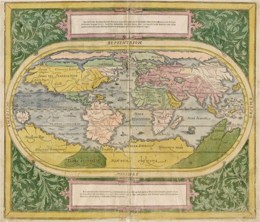
Die erste General. Die Erste Landtafel begreifft in sich der ganzen Erdkugel umkreiß
First Published
Basle, 1588
This Edition
1592 German
Size
30.8 x 36.0 cms
Technique
Condition
excellent
Price
This Item is Sold
Description
In 1588, this woodcut map replaced the earlier outdated 1550 map of the world that had been in use in Munster's Cosmographia.
This new map is modeled after Abraham Ortelius' 1570 landmark map of the world, which was designed and engraved by Frans Hogenberg. The geography was an improved model of Gerard Mercator's 1569 wall map of the world, as well as Gastaldi's 1561 map of the world.
It is of particular interest because the map is "engraved in woodblock in the copperplate manner", a new technique that was developed to improve the quality of woodcut maps, while at the same time keeping the costs lower by avoiding the need for expensive copper plates. Technically speaking, this means that the woodblock is used for intaglio printing instead of the traditional relief printing.
Munster's updated and modernized maps of 1588 are of high significance because they were much more widespread than the original Ortelius copperplate maps upon which they are based.
Munster's Cosmographia sold in huge quantities all over Europe, because it was far more affordable than the folio atlases by Ortelius. More than 42 editions of the Cosmographia were published between 1550 and 1628, in five languages.
Another reason for its success was the fact that the Cosmographia was not just an atlas, it was more like an encyclopedia with vast amounts of knowledge about the history of the world, about religion, about all imaginable sciences (mining, medical, masonry, chemistry, distillation), and about European and overseas cultures and etnography. As well as about voyages of discovery and the geography of the world.
With a great depiction of the enormous and unknown Southland (TERRA AVSTRALIS NONDUM COGNITA)
Condition
Early imprint, from the 1592 German edition. Attractive woodcut on verso with the Allmighty ruling the earth, flanked by one of the archangels, and between two scenes of human miseries. Upper margin short. Lower margin with a very old extension, most likely a contemporary strengthening. In original colour, which is unobtainable for Munster woodcuts, the kind of item that is lacking in every collection. A very desirable collector's item.
Sebastian Münster (1489-1552)
Following the various editions of Waldseemüller's maps, the names of three cartographers dominate the sixteenth century: Mercator, Ortelius and Münster, and of these three Münster probably had the widest influence in spreading geographical knowledge throughout Europe in the middle years of the century.
His Cosmographia, issued in 1544, contained not only the latest maps and views of many well-known cities, but included an encyclopaedic amount of detail about the known - and unknown - world and undoubtedly must have been one of the most widely read books of its time, going through nearly forty editions in six languages.
An eminent German mathematician and linguist, Münster became Professor of Hebrew at Heidelberg and later at Basle, where he settled in 1529. In 1528, following his first mapping of Germany, he appealed to German scholars to send him "descriptions, so that all Germany with its villages, towns, trades, etc. may be seen as in a mirror", even going so far as to give instructions on how they should "map" their own localities. The response was far greater than expected and such information was sent by foreigners as well as Germans so that, eventually, he was able to include many up-to-date, if not very accurate, maps in his atlases.
He was the first to provide a separate map of each of the four known Continents and the first separately printed map of England. His maps, printed from woodblocks, are now greatly valued by collectors. His two major works, the Geographia and the Cosmographia were published in Basle by his step-son, Henri Petri, who continued to issue many editions after Münster's death of the plague in 1552.
(Moreland & Bannister).
The remaining modern maps, [...], are all drawn on a plane projection, undergraduated, without scales, and variously oriented with north, south, east or west at the top, "without the excuse of topographical necessity", as Nordenskjöld severely remarks. In spite of these and other cartographic defects, they constitute an important corpus of geographical knowledge and interpretation; Münster was the first atlas-maker to furnish separate maps of the four continents then known; and for England, Scandinavia and southern Germany, eastern Europe and America he brought recent and significant representations into general currency.
(Skelton).
The Cosmographia of Sebastian Münster must rank as the greatest geographical compendium of the period - an immensely detailed work illustrated with woodcut portraits, scenes, town plans and panoramas, and maps. Born in 1488, Münster was a Fransiscan who became Professor of Hebrew at Heidelberg and later at Basle, where he taught Hebrew and, amongst other works, published the first German translation of the Bible from Hebrew. In 1540 his edition of Ptolemy's Geographia was published, followed in 1544 by the Cosmographia Universalis. Together these ran to over 35 editions published mostly in Basle in Latin, German, French and Italian versions. Münster's particular cartographic importance lies in the number of 'new' maps he introduced and, above all, in the innovative, separate mapping of each of the four continents. The map of the Americas is not only the first map to show the Western Hemisphere separately, but is also the first to show North and South America joined together.
(Potter p38).
Sebastian Münster was raised as a Franciscan monk, converted to Lutheranism, taught Hebrew at Heidelberg and Basle, and was proficient in Greek and some Asian tongues. He died of the plague in 1552. First published in 1540, his atlas was the first to contain separate maps of each of the four continents.
(Suárez).
In 1540 Sebastian Münster, who was to become one of the most influential cartographers in the sixteenth century, published his edition of Ptolemy's Geographia with a further section of modern, more up-to-date maps. He included for the first time a set of continental maps, the America was the earliest of any note. Münster studied Hebrew at Heidelberg and was a scholar of geography, writing amongst other works the Polyhistor.
He was one of the first to create space in the woodblock for the insertion of place-names in metal type. The map's inclusion in Münster's Cosmography, first published in 1544, sealed the fate of "America" as the name for the New World. The book proved to be very popular, there being nearly forty editions during the following 100 years.
(Burden).
Abraham Ortelius (1527-1598)
Abraham Ortelius is the most famous and most collected of all early cartographers. In 1570 he published the first comprehensive collection of maps of all parts of the world, the Theatrum Orbis Terrarum ("Theatre of the World"), the first modern atlas as we know it.
"Abraham Ortel, better known as Ortelius, was born in Antwerp and after studying Greek, Latin and mathematics set up business there with his sister, as a book dealer and ‘painter of maps'. Traveling widely, especially to the great book fairs, his business prospered and he established contacts with the literati in many lands. On one such visit to England, possibly seeking temporary refuge from religious persecution, he met William Camden whom he is said to have encouraged in the production of the Britannia.
A turning point in his career was reached in 1564 with the publication of a World Map in eight sheets of which only one copy is known: other individual maps followed and then – at the suggestion of a friend - he gathered together a collection of maps from contacts among European cartographers and had them engraved in uniform size and issued in 1570 as the Theatrum Orbis Terrarum (Atlas of the Whole World). Although Lafreri and others in Italy had published collections of ‘modern' maps in book form in earlier years, the Theatrum was the first uniformly sized, systematic collection of maps and hence can be called the first atlas, although that term itself was not used until twenty years later by Mercator.
The Theatrum, with most of its maps elegantly engraved by Frans Hogenberg, was an instant success and appeared in numerous editions in different languages including addenda issued from time to time incorporating the latest contemporary knowledge and discoveries. The final edition appeared in 1612. Unlike many of his contemporaries Ortelius noted his sources of information and in the first edition acknowledgement was made to eighty-seven different cartographers.
Apart from the modern maps in his major atlas, Ortelius himself compiled a series of historical maps known as the Parergon Theatri which appeared from 1579 onwards, sometimes as a separate publication and sometimes incorporated in the Theatrum."
(Moreland and Bannister)
"The maker of the ‘first atlas', the Theatrum Orbis Terrarum (1570), started his career as a colorist of maps. Later, he became a seller of books, prints and maps. His scientific and collecting interests developed in harmony with those of a merchant. He was first and foremost a historian. Geography for him was the ‘eye of history', which may explain why, in addition to coins and historical objects, he also collected maps. On the basis of his extensive travels through Europe and with the help of his international circle of friends, Ortelius was able to build a collection of the most up-to-date maps available.
The unique position held by Ortelius's Theatrum in the history of cartography is to be attributed primarily to its qualification as ‘the world's first regularly produced atlas.' Its great commercial success enabled it to make a great contribution to ‘geographical culture' throughout Europe at the end of the sixteenth century. Shape and contents set the standard for later atlases, when the centre of the map trade moved from Antwerp to Amsterdam. The characteristic feature of the Theatrum is that it consists of two elements, text and maps. Another important aspect is that it was the first undertaking of its kind to reduce the best available maps to a uniform format. To that end, maps of various formats and styles had to be generalized just like the modern atlas publisher of today would do. In selecting maps for his compilation, Ortelius was guided by his critical spirit and his encyclopaedic knowledge of maps. But Ortelius did more than the present atlas makers: he mentioned the names of the authors of the original maps and added the names of many other cartographers and geographers to his list. This ‘catalogus auctorum tabularum geographicum,' printed in the Theatrum, is one of the major peculiarities of the atlas. Ortelius and his successors kept his list of map authors up-to-date. In the first edition of 1570 the list included 87 names. In the posthumous edition of 1603, it contained 183 names.
Abraham Ortelius himself drew all his maps in manuscript before passing them to the engravers. In the preface to the Theatrum he stated that all the plates were engraved by Frans Hogenberg, who probably was assisted by Ambrosius and Ferdinand Arsenius (= Aertsen). The first edition of the Theatrum is dated 20 May 1570 and includes 53 maps.
The Theatrum was printed at Ortelius's expense first by Gielis Coppens van Diest, an Antwerp printer who had experience with printing cosmographical works. From 1539 onwards, Van Diest had printed various editions of Apianus's Cosmographia, edited by Gemma Frisius, and in 1552 he printed Honterus's Rudimentorum Cosmograhicorum... Libri IIII. Gielis Coppens van Diest was succeeded as printer of the Theatrum in 1573 by his son Anthonis, who in turn was followed by Gillis van den Rade, who printed the 1575 edition. From 1579 onwards Christoffel Plantin printed the Theatrum, still at Ortelius's own expense. Plantin and later his successors continued printing the work until Ortelius's heirs sold the copperplates and the publication rights in 1601 to Jan Baptist Vrients, who added some new maps. After 1612, the year of Vrients's death, the copperplates passed to the Moretus brothers, the successors of Christoffel Plantin.
The editions of the Theatrum may be subdivided into five groups on the basis of the number of maps. The first group contains 53 maps, 18 maps were added. The second group has 70 maps (one of the 18 new maps replaced a previous one). In 1579 another expansion was issued with 23 maps. Some maps replaced older ones, so as of that date the Theatrum contained 112. In 1590 a fourth addition followed with 22 maps. The editions then had 134 maps. A final, fifth expansion with 17 maps followed in 1595, bringing the total to 151."
(Peter van der Krogt, Atlantes Neerlandici New Edition, Volume III)
Related Categories
Related Items


