Leen Helmink Antique Maps
Antique map of Chusan (Zhoushan) / Zhejiang by van Keulen
The item below has been sold, but if you enter your email address we will notify you in case we have another example that is not yet listed or as soon as we receive another example.
 / Zhejiang by van Keulen")
Stock number: 19203
Zoom ImageCartographer(s)
Johannes van Keulen II (biography)
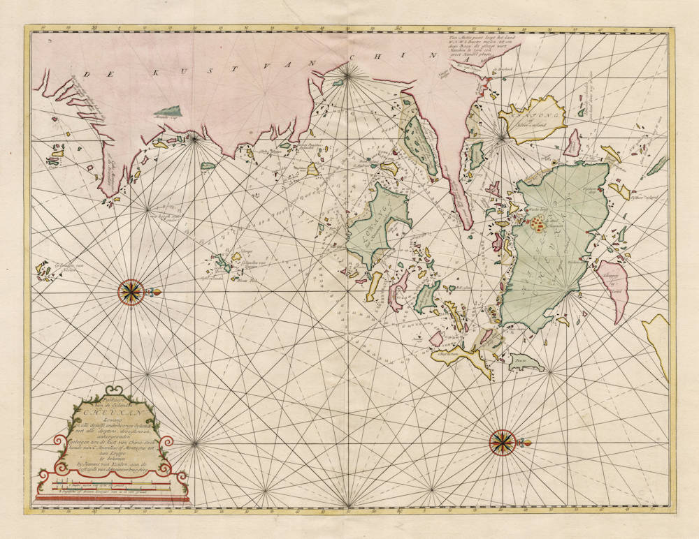
Title
Paskaart van de Eylanden Cheuxan Lowang
First Published
Amsterdam, 1753
This Edition
1753 first and only edition
Size
40.5 x 53.2 cms
Technique
Condition
mint
Price
This Item is Sold
Description
A highly important and exceptionally rare sea chart from 1753, and the first accurate map of these waters. The chart covers the important Chinese coasts and islands of Zhoushan (Chusan) located in the Yangtze River Delta, across the mouth of the Hangzhou Bay (Hangchow Bay). North is to he right of the chart, which means that west is on top of the map.
The chart is of great historical significance and a major cultural milestone in the history of the trade between Holland and China.
The chart is decorated with a very elegant title cartouche, two scalebars, and two compass roses. It has many details of shallows, shoals and reefs, depth soundings for safely navigating and approaching these harbours.
This chart was forbidden and secret from both Dutch and Chinese perspective.
It was forbidden from a Dutch point of view. The Dutch East India Company (VOC) printed it only for use on board of their own ships, it was a secret map from a secret atlas or chartbook that should not fall into the hands of the competitors from Europe, like England, France, Spain, etc. Each of the navigational officers(captain and steersmen) had to sign for the chart inventory upon receipt and was required to return all the material upon completing the journey to Batavia (Djakarta). In the event of missing or mishandled charts, they received severe fines and punishment.
It was also forbidden from a Chinese point of view. For centuries, Chinese waters were forbidden territory for foreign ships and foreigners were not allowed to do trade with China, except via Canton (Guangzhou).
When we consider that a certain amount of trade had always been carried on between China and Western countries by the overland route through Central Asia, it seems strange that so many obstacles were put in the way of trade by the new sea routes. The obstinate attitude of the Chinese Government was due to many causes. The area had been notorious for intrusion by Japanese pirates (permission for city walls was granted to Shanghai and Chusan in 1554). Undoubtedly the piratical incursions of the Portuguese traders along the coast injured the reputation of Western traders, and gave some excuse for regarding them as barbarians.
Another reason for the strong opposition was that these merchants from the West were demanding the privilege of trade as a right to which they were entitled, and asked that commercially and diplomatically they should be treated on terms of equality.
Furthermore, the trade of the overland routes had been very limited in scope, while that by the sea route was carried on on a much larger scale. In those days China regarded imports as an evil and thought that the purchase of foreign goods resulted in the outflow of money and in the consequent impoverishment of the country.
The Dutch East India Company (VOC) never did official trade in this area, and the inaccuracies in the chart show that there are many uncertainties about the geography. For instance, a legend in the upper left states that this area is hardly known. Also, a text near the Ningbo River entrance (near Zhenhai, there are several watch towers and guard houses indicated there) states that a famous trading city named Hangzhou is said to be about 6 seamiles further up the bay. Apparently it was too dangerous to go there, because the real distance is another 100 seamiles.
Some of the knowledge clearly comes from the Company's own chartings in the area (detailed depth soundings, bearings, coastal profiles, tide information, dangerous reefs, shallows and banks, etc). Some of the knowledge must have come from older Portuguese sources, as can be seen from some Portuguese names on the map (Cabo Montagne. Avarellas). In the 16th century, the Portuguese Jesuits had received permission to have several offices in China, under condition that no trade would be done. Especially Matteo Ricci was very successful from 1582 onwards, he managed to get Jesuit posts in Peking (Beijing), Canton, Chusan and several other cities. More than 200 high Chinese officials were converted at the time, and this map mentions that Chusan is also known as "Papen" island, a Dutch reference to the Jesuits still being there in 1753 when this chart was made.
Despite this area being forbidden territory for foreign traders, merchant ships from the East India Company must have entered these areas occasionally, to shelter from bad weather (many anchoring sites away from inhabited places are given in detail), and to secretly take in provisions and victuals (on the map there are many indications where fresh water can be found, and where exactly the fishing junks and fishing villages are located). Because the chart shows a tiny VOC flag near the city of Chusan, there is no doubt that they also did some forbidden secret trading here, most probably textiles, silk, porcelain, silver and gold. We know from the East India Company records that the Chinese were always keen on doing business, and the emperor and authorities in Peking (Beijing) were far away.
Owing to the difficulties under which trade was carried on in the trading posts at Canton, several attempts were later made in the 18th and 19th century by British merchants to open up new points of access. One of the requests of Lord Macartney's embassy to emperor Qianlong in 1793 was an acquisition of "a small unfortified island near Zhoushan for the residence of English traders, storage of goods, and outfitting of ships." Emperor Qianlong denied this request together with all the rest.
In 1832 the English East India Company despatched the ship "Lord Amherst" from Macao on a commercial mission in charge of Mr. Hugh Hamilton Lindsay. Wherever he called along the coast, he met a series of rebuffs. After failing to gain admittance into Amoy, Foochow, Chusan, and Ningpo, he proceeded to Shanghai. The officials of that port had been notified of his coming and were prepared to oppose his entrance into the harbour. He managed, however, to obtain an interview with the Taotai, the official in charge of trade, in the temple of the Queen of Heaven. Although received with scant courtesy, he was able to present his petition. He was told, however, that the right of trade could only be allowed at Canton and was advised to return there as soon as possible. Trade with the area being impossible, Mr. Lindsay left. The area was not opened up for trade until 1842. After that time, Zhoushan became a large and well known port while Hong Kong was only a fishing village.
Because this Dutch VOC chart of 1753 was secret and not officially published, it is now exceptionally rare, and only a handful of examples have survived.
The chart was included in an extremely rare sea atlas by Johannes (II) van Keulen, the Zee-Fakkel Part VI, issued in 1753, the so-called secret atlas of the Dutch East India Company, of this atlas only a few copies have survived.
For many regions in Asia and Africa, the printed maps from this atlas are the first, the best and the only accurate early maps.
These maps are never in the market, and they are beyond doubt the most desirable of early printed maps of the Far East and China.
For two centuries, from 1602 to 1799, the Dutch East India Company (the VOC) ruled the waters of Asia and Africa. Accurate charting of these waters was essential for successful and safe navigation.
The VOC had their own mapmaking office. During the first 150 years, only secret manuscript charts were used, to minimize the risk of spreading the knowledge to competitors. But from 1753 onwards, a printed atlas was used, the van Keulen Zee-Fakkel Part VI, with printed charts to navigate the waters from South Africa to Japan.
There was a variety of reasons for printing the VOC maps:
First, in the course of 150 years the knowledge of these waters had leaked out to other European nations and secrecy was of less importance.
Second, printed maps were more accurate and less prone to errors than manuscript copies.
Third, loose maps were impractical and sometimes lost despite the strict
policies of use.
Fourth, in the course of 150 years the knowledge of these waters had leaked out to other European nations and secrecy was of less importance.
And last, but not least, printed maps were cheaper to (re-)produce than manuscript maps.
The atlas is known as the secret atlas of the East India Company, because it was not sold to third parties and only used on board of VOC ships. For this reason it is extremely rare, and only few have survived. Further, the number if charts in the atlas is often limited because ships that did not sail to India / Ceylon or China / Formosa / Japan were given versions of the atlas that did not contain the charts of these areas, making many of the maps even rarer.
APPENDIX:
transcription and English translation of all Dutch texts on the chart
_________________________________________________________
Chart title, in elegant cartouche in lower left:
Paskaart
van de Eylanden
CHEUXAN
Lowang
en alle desselfs onderhoorige Eylande
met alle dieptens, droogtens en
ankergronden,
geleegen aen de kust van China strek=
kende van C. Avarellas of Montagne tot
aan Lingpo.
te bekomen
by Joannes van Keulen, aan de
Oostzyde van de nieuwe brug-steeg
Navigation chart
of the Islands
CHEUXAN
Lowang
and all the corresponding subsidiary Islands
with all depths, shallows and
anchoring grounds,
lying on the coast of China
stretching from Cape Avarellas or Cape Montagne to
Lingpo.
can be bought
from Joannes van Keulen, at the
East side of the new bridge alley in Amsterdam
___________________
Two scalebars:
6 Duytse mylen van 15 in een graad.
8 Engelsche of Franse Leagues van 20 in een graad.
6 German miles of 15 in one degree.
8 English or French Leagues of 20 in one degree.
___________________
DE KUST VAN CHINA
THE COAST OF CHINA
___________________
Dit is nog niet anders bekent als na de oudste kaarten en hoeft verbetering
This is not known other than after the oldest charts en needs improvement
___________________
Goese
Goese Island
___________________
Cabo Montagne of de Avarellas
Cape Montagne also known as Cape Avarellas
___________________
Monniks-Cap
Monk's Hood (coastal profile as seen from the bay)
___________________
De Beer
The Bear
___________________
met hoogh water onder [gevaarlijk rif]
at high tide flooded under water [dangerous reef or shoal]
___________________
Klumpe
Wooden Shoes [Clogs, after profile form of island]
___________________
Eylanden van Quesan
Eylands of Quesan
___________________
Groot Quesan
Greater Quesan
__________________
Tafel=eylanden
Table Islands [flat profile]
___________________
Blonte Piek
Blunt Peak
___________________
Eylanden van Hesan
Islands of Hesan
___________________
Gluks=klippen
Chance rocks
___________________
Kers=en Paaschen=eylanden
Christmas and Easter islands
___________________
Casteel=klip
Castle rock
___________________
Buffelows neus
Buffalo's nose
___________________
vers water
fresh water
___________________
de Corkers
the Corkers
___________________
de beste Passagie na Cheu-xan
the best sailing passage to Cheuxan
___________________
Boom=eyland
Tree island
___________________
S. Andries
S. Andrew
___________________
Foetosan
Foetosan
___________________
Dit is laag land, dat met spring=tyd onder water staat behalve de eylanden
These are low lands, that are flooded with sping-tide except for the islands
___________________
de 10 voet vaart voor kleyne Jonken
the 10 foot passage for small Junks
___________________
hoog land
high lands
___________________
LOWANG of het Kroonen-eyland
LOWANG or the Crown's island
___________________
Philipps klip en punt
Philipp's rock and cape
___________________
Witte klip
White rock
___________________
Caap Lowang
Cape Lowang
___________________
Witte coms baay
White basin bay
___________________
2 broeders
2 brothers [twin islands]
___________________
Vernoms eyland
Vernom's island
___________________
Towhys wayn
vers water
Towhys wayn
fresh water
___________________
Jansens rust
Jansen's grave
___________________
Van Mutes punt loopt het land W.N.W. 6 Duytse mylen, tot een
diepe Baay, die gezegt wort Hansheu te zyn een groot Handel plaats.
From Mutes point the land continues West-North-West 6 German miles,
to a deep Bay, which is said to be Hanzhou alarge Trading city
___________________
Mutes punt.
Mutes cape.
___________________
Riv. van Ningpo.
River of Ningpo.
___________________
Ningpo of Lingpo.
Ningpo also known as Lingpo.
___________________
de Driehoek
the Triangle
___________________
de Wacht toorens
the Watch towers
___________________
Edmonds-eylanden
Edmonds-islands
___________________
Geen land deeze weg te zien
No land to be seen this way
___________________
HIMTONG of Silver=eyland
HIMTONG or Silver island
___________________
dwars in de weg
standing in the way [ island or rocks in the channel ]
___________________
't vaar water voor schepen na Lingpo
channel for the ships to Lingpo
___________________
Tygesan
Tygesan
___________________
S.Georg
S.George
___________________
Hoog land langs deeze kust
High lands along this coast
___________________
Kittow punt het alder hoogste
Point Kittow the highest cape
___________________
anker grond
anchoring ground
___________________
Singlosan
Singlosan
___________________
Tower=hill
Tower hill
___________________
Oliphants Snevel
Elephant's trunk [after form of island]
___________________
Bell eyland
Bell island
___________________
Tingboo
Tingboo
___________________
Chuttatam
Chuttatam
___________________
Blakwall=eyland.
Black wall island
___________________
N.W. eylanden
North West islands
___________________
Geen land deeze weg te zien
No land to be seen this way
___________________
't lange eyland
the long island
___________________
5.5 voet met springtyden
5.5 foot during spring tide
___________________
klip bovenwater
rock above water
___________________
Pellican klip
Pelican's rock
___________________
HET EYLAND CHEUXAN of Het Papen-eyland
THE ISLAND CHEUXAN or The Island of the Jesuits
___________________
Foplar I.
Foplar Island
___________________
Modderbank met half ty droog
Mudbank dry at half tide
___________________
Vischers=dorp
Fisher's village
___________________
Vischers=eyland
Fisher's island
___________________
Wacht huys
Guard-house
___________________
de Stad Cheuxan
the City of Cheuxan
___________________
Vischers dorp
Fisher's village
___________________
Scheppey ey=land
Scheppey island
___________________
Dier=ey=land
Animal island
___________________
Vischer=huyzen
Fishermen's houses
___________________
Sinquamong eylanden
Sinquamon islands
___________________
Twee Susters
Two Sisters [twin islands]
___________________
met laag water droog
dry at low tide
___________________
Powto
Powto
___________________
Johannes van Keulen (1654-1711)
Gerard van Keulen (son) (1678-c.1727)
Johannes van Keulen II (grandson) (active 1726-1755)
The Dutch produced a remarkable number of enterprising and prolific map and chart makers but not even the Blaeu and Jansson establishments could rival the vigour of the van Keulen family whose business was founded in 1680 and continued under their name until 1823 and in other names until 1885 when it was from wound up and the stock dispersed at auction.
Throughout the history of the family, the widows several of the van Keulens played a major part, after their husbands' deaths, in maintaining the continuity of the business. The firm was founded by Johannes van Keulen who was registered as a bookseller in Amsterdam in 1678. In 1680 he published the first part of his 'Zee Atlas' which, over the years, was expanded to 5 volumes and continued in one form or another until 1734. More ambitious and with a far longer and more complicated life was his book of sea charts, the 'Zee-Fakkel', first published in 1681–82, which was still being printed round the year 1800. A major influence in the development of the firm was the acquisition in 1693 of the stock of a rival map publisher, Hendrik Doncker.
Although the firm was founded by Johannes van Keulen, he was primarily a publisher; it was his son, Gerard, a talented engraver, mathematician, Hydrographer to the East India Company, who became mainspring of the business which not only published charts but also books on every aspect of geograpy, navigation and nautical matters,
(Moreland and Bannister)
It was grandson Johannes van Keulen (II) who in 1753 produced Volume VI of the Zee-Fakkel for the VOC East Indiamen, containing printed charts for the navigation covering the waters from the Cape of Good Hope to Nagasaki . The atlas was not commercially sold and only for use on board of VOC ships, therefore it is also refered to as the 'secret atlas' odf the VOC. The engraving quality and craftmanship surpasses that of all earlier printed sea charts.
Sea charts from the secret atlas are among the rarest and most desirable sea charts for collectors.
Related Categories
Related Items


