Leen Helmink Antique Maps
Antique map of the World by Ortelius
The item below has been sold, but if you enter your email address we will notify you in case we have another example that is not yet listed or as soon as we receive another example.

Stock number: 19191
Zoom ImageCartographer(s)
Abraham Ortelius (biography)
Title
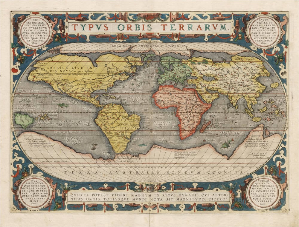
Typus Orbis Terrarum
First Published
Antwerp, 1589
This Edition
1592 Latin
Size
33.7 x 49.3 cms
Technique
Condition
mint
Price
This Item is Sold
Description
Pristine example of Ortelius' most desirable third and final map of the world.
The Ortelius map was one of the most influential maps of the world of the 16th Century. It was the first map in the Theatrum Orbis Terrarum, the first modern atlas of the world that would for many decades dominate the markets and determine the way that mankind viewed the world that was rapidly being unveiled by the voyages of exploration and discovery.
For geographical content, the map is a fascinating amalgamation to reconcile the latest explorations by the Portuguese, Spanish, French and English seafarers with the medieval sources as well as with the ancient geographical sources that had been passed down from Classical Antiquity.
Condition
Very early dark and even imprint of the copperplate, from a deluxe 1592 Latin edition. It was the first edition published by Plantin, who made sure that this edition was superb. This edition was produced during Ortelius' lifetime and under his personal supervision, which is a premium for Ortelius maps. Thick and strong paper, wide margins, no discolouration of the paper, old unobtrusive repair to minor split in lower centerfold, else no imperfections or restorations. Stunning vibrant original colour. Pristine collector's example of one of the most iconic and sought-after early maps of the world.
The Mapping of the World
Ortelius' third and last world map plate is dated 1587 under the author's signature. Loose copies seem to have been in circulation from 1588 onwards although the map did not appear in the Theatrum until the Latin text edition of 1592. This new map is easily recognised by the four medallions in the corners with classical texts; two from Cicero and two from Seneca. The earlier border of clouds has been replaced by a more intricate and elegant lattice of strapwork and swag. Note the cardinal spelt Septemtrio rather than Septentrio.
The oval world map used previously has been updated in two major respects: South America now assumes the more correct shape anticipated in state 3 of Ortelius' second plate, and the Solomon Isles are marked for the first time. This third plate was used for all subsequent editions of the Theatrum up to 1612 as listed below.
1592 (Latin)
1595 (Latin)
1598 (French)
1601 (Latin)
1602 (Spanish)
1602 (German)
1603 (Latin)
1606 (English)
1608 (Italian)
1609 (Latin)
1610 (Dutch)
1612 (Latin)
1612 (Italian)
1612 (Spanish)
(Shirley map 158)
Transcriptions and translations of texts appearing on the map
Title:
TYPVS ORBIS TERRARVM.
[Image of the world].
Bottom cartouche:
QVID EI POTEST VIDERI MAGNVM IN REBVS HVMANIS, CVI ÆTER|NITAS OMNIS, TOTIVSQVE MVNDI NOTA SIT MAGNITVDO. CICERO:
[Who can consider human affairs to be great, when he comprehends the eternity and vastness of the entire world? Cicero]
[Tusculan Disputations 4.37]
Across the North Pole:
TERRA SEPTEMTRIONALIS INCOGNITA.
[Unknown Northern Land.]
Across the Southland:
TERRA AUSTRALIS NONDUM COGNITA.
[South Land not yet known.]
Lower right corner on the Southland:
Ab. Ortelius describ. cum | priuilegio decennali.|1587.
[Described by Abraham Ortelius, with a ten year privilege. 1587.]
Top left medaillon:
HOMI|NES HAC LEGE | SVNT GENERATI, | QUI TVERENTVR | ILLVM GLOBVM, | QVEM IN HOC TEM|PLO MEDIVM VI|DES, QUÆ TER|RA DICITVR. Cicero.
[The horse is for riding, the ox for ploughing, the dog for hunting and guarding, but man was born to contemplate the world. Cicero.]
["Republica" 6.15.].
Top right medaillon:
EQVVS | VEHENDI | CAVSA, ARANDI | BOS VENANDI | ET CVSTODIENDI | CANIS, HOMO AV|TEM ORTVS AD | MVNDVM CON|TEMPLANDVM. Cicero.
[People have been created under the law that they should protect this globe which you see in the middle of this image which is called earth. Cicero.]
["Natura Deorum" 2.37].
Lower left medaillon:
HOC | EST PVNCTVM, | QVOD INTER TOT | GENTES FERRO | ET IGNI DIVI|DITVR. O QVAM RIDI|CVLI SVNT MOR|TALIVM TER|MINI. Seneca.
[This is the time when [the world] is divided by the fire and sword of many nations. How ridiculous are the goals of mortal beings. Seneca.]
["Naturæ Quæstiones" 1. præfatio 8-9].
Lower right medaillon:
VTINAM | QVEMADMO|DVM VNIVERSA | MVNDI FACIES | IN CONSPECTVM | VENIT, ITA PHI|LOSOPHIA TOTA | NOBIS POSSET | OCCVRRERE. Seneca.
[We wish, just like the universe and face of the world comes into view, that it could similarly happen that philosophy could be made visible to us. Seneca.]
[Epistle 89.1].
In North America:
AMERICA SIVE IN:|DIA NOVA, Ao 1492 a Christopohoro | Colombo nomine regis Castellæ primum detecta.
[America or the New Indies, first discovered by Christopher Columbus in 1492 for the king and queen of Castilia.]
On New Guinea:
Noua Guinea, | "quæ an sic insula | aut pars continentis | Australis, incertum.
[New Guinea. Whether this is an island or part of the Southern continent is uncertain.]
Lower left below New Guinea:
Hanc continentem | Australem , nonnulli | Magellanicam regionem ab | eius inventore nuncupant.
[This Southern continent is by some called the Magellan region after its discoverer.]
Below South Africa:
Psitacorum regio, | sic a Lusitanis appellata ob incre:|dibilem earum avium ibidem | magnitudem
[The region of the Psitaces, so called by the Portuguese because of its incredibile amount of birds of the same size.]
Lower left below New Guinea:
Hanc continentem | Australem , nonnulli | Magellanicam regionem ab | eius inventore nuncupant.
[This Southern continent is by some called the Magellan region after its discoverer.]
Lower left below New Guinea:
Vastissimas hic eße | regiones ex M. Pauli Ven: et | Lud. Vartomanni scriptis pe:|regrinationibus constat.
[These regions are very extended as can be seen in the writings of Marco Polo and the travels of Ludovicus Vartomannus.]
(van den Broecke map 3)
Abraham Ortelius (1527-1598)
Abraham Ortelius is the most famous and most collected of all early cartographers. In 1570 he published the first comprehensive collection of maps of all parts of the world, the Theatrum Orbis Terrarum ("Theatre of the World"), the first modern atlas as we know it.
"Abraham Ortel, better known as Ortelius, was born in Antwerp and after studying Greek, Latin and mathematics set up business there with his sister, as a book dealer and ‘painter of maps'. Traveling widely, especially to the great book fairs, his business prospered and he established contacts with the literati in many lands. On one such visit to England, possibly seeking temporary refuge from religious persecution, he met William Camden whom he is said to have encouraged in the production of the Britannia.
A turning point in his career was reached in 1564 with the publication of a World Map in eight sheets of which only one copy is known: other individual maps followed and then – at the suggestion of a friend - he gathered together a collection of maps from contacts among European cartographers and had them engraved in uniform size and issued in 1570 as the Theatrum Orbis Terrarum (Atlas of the Whole World). Although Lafreri and others in Italy had published collections of ‘modern' maps in book form in earlier years, the Theatrum was the first uniformly sized, systematic collection of maps and hence can be called the first atlas, although that term itself was not used until twenty years later by Mercator.
The Theatrum, with most of its maps elegantly engraved by Frans Hogenberg, was an instant success and appeared in numerous editions in different languages including addenda issued from time to time incorporating the latest contemporary knowledge and discoveries. The final edition appeared in 1612. Unlike many of his contemporaries Ortelius noted his sources of information and in the first edition acknowledgement was made to eighty-seven different cartographers.
Apart from the modern maps in his major atlas, Ortelius himself compiled a series of historical maps known as the Parergon Theatri which appeared from 1579 onwards, sometimes as a separate publication and sometimes incorporated in the Theatrum."
(Moreland and Bannister)
"The maker of the ‘first atlas', the Theatrum Orbis Terrarum (1570), started his career as a colorist of maps. Later, he became a seller of books, prints and maps. His scientific and collecting interests developed in harmony with those of a merchant. He was first and foremost a historian. Geography for him was the ‘eye of history', which may explain why, in addition to coins and historical objects, he also collected maps. On the basis of his extensive travels through Europe and with the help of his international circle of friends, Ortelius was able to build a collection of the most up-to-date maps available.
The unique position held by Ortelius's Theatrum in the history of cartography is to be attributed primarily to its qualification as ‘the world's first regularly produced atlas.' Its great commercial success enabled it to make a great contribution to ‘geographical culture' throughout Europe at the end of the sixteenth century. Shape and contents set the standard for later atlases, when the centre of the map trade moved from Antwerp to Amsterdam. The characteristic feature of the Theatrum is that it consists of two elements, text and maps. Another important aspect is that it was the first undertaking of its kind to reduce the best available maps to a uniform format. To that end, maps of various formats and styles had to be generalized just like the modern atlas publisher of today would do. In selecting maps for his compilation, Ortelius was guided by his critical spirit and his encyclopaedic knowledge of maps. But Ortelius did more than the present atlas makers: he mentioned the names of the authors of the original maps and added the names of many other cartographers and geographers to his list. This ‘catalogus auctorum tabularum geographicum,' printed in the Theatrum, is one of the major peculiarities of the atlas. Ortelius and his successors kept his list of map authors up-to-date. In the first edition of 1570 the list included 87 names. In the posthumous edition of 1603, it contained 183 names.
Abraham Ortelius himself drew all his maps in manuscript before passing them to the engravers. In the preface to the Theatrum he stated that all the plates were engraved by Frans Hogenberg, who probably was assisted by Ambrosius and Ferdinand Arsenius (= Aertsen). The first edition of the Theatrum is dated 20 May 1570 and includes 53 maps.
The Theatrum was printed at Ortelius's expense first by Gielis Coppens van Diest, an Antwerp printer who had experience with printing cosmographical works. From 1539 onwards, Van Diest had printed various editions of Apianus's Cosmographia, edited by Gemma Frisius, and in 1552 he printed Honterus's Rudimentorum Cosmograhicorum... Libri IIII. Gielis Coppens van Diest was succeeded as printer of the Theatrum in 1573 by his son Anthonis, who in turn was followed by Gillis van den Rade, who printed the 1575 edition. From 1579 onwards Christoffel Plantin printed the Theatrum, still at Ortelius's own expense. Plantin and later his successors continued printing the work until Ortelius's heirs sold the copperplates and the publication rights in 1601 to Jan Baptist Vrients, who added some new maps. After 1612, the year of Vrients's death, the copperplates passed to the Moretus brothers, the successors of Christoffel Plantin.
The editions of the Theatrum may be subdivided into five groups on the basis of the number of maps. The first group contains 53 maps, 18 maps were added. The second group has 70 maps (one of the 18 new maps replaced a previous one). In 1579 another expansion was issued with 23 maps. Some maps replaced older ones, so as of that date the Theatrum contained 112. In 1590 a fourth addition followed with 22 maps. The editions then had 134 maps. A final, fifth expansion with 17 maps followed in 1595, bringing the total to 151."
(Peter van der Krogt, Atlantes Neerlandici New Edition, Volume III)
Related Categories
Related Items


