Leen Helmink Antique Maps
Antique map of Southeast Asia by Langenes
The item below has been sold, but if you enter your email address we will notify you in case we have another example that is not yet listed or as soon as we receive another example.

Stock number: 19145
Zoom ImageCartographer(s)
Title
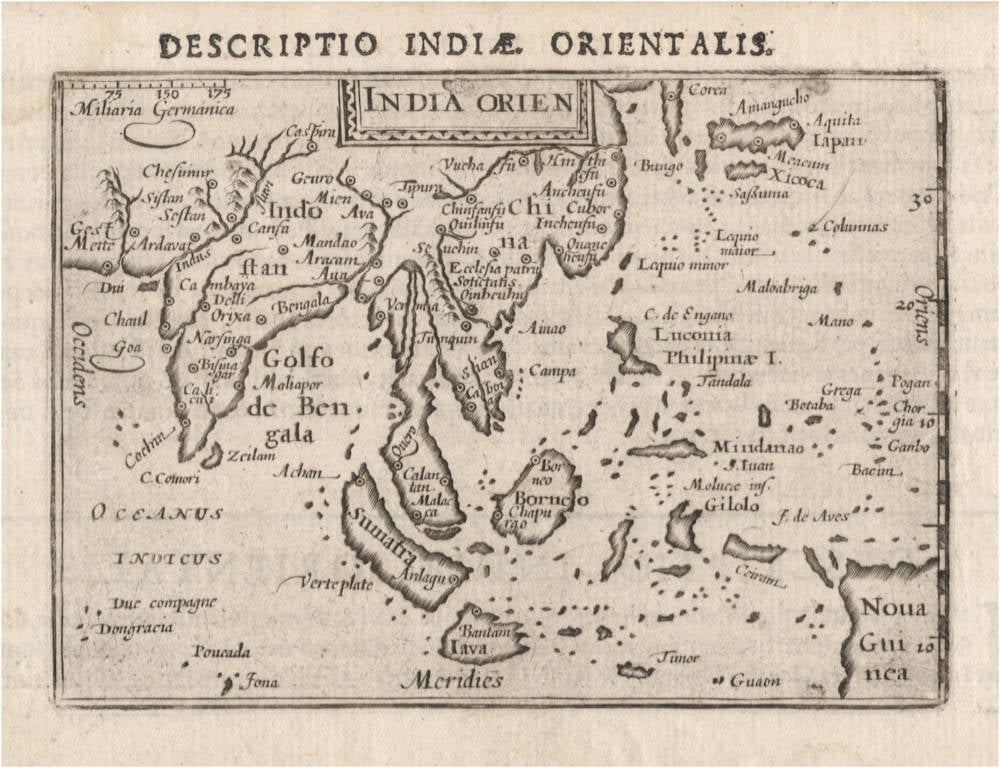
India Orien(talis)
First Published
Middelburg, 1598
This Edition
Amsterdam, 1606
Size
8.7 x 12.3 cms
Technique
Condition
excellent
Price
This Item is Sold
Description
Seminal map of the East Indies, from Caert Thresoor ("Treasure Maps"), the first world atlas published in the Northern Netherlands. The atlas was a pocket atlas of modest size, but highly influential. The atlas was directly competing with Abraham Ortelius' Epitome pocket atlas.
Interestingly, the publication of this atlas and this map coincided with the return of the first Dutch fleet to the Indies who made a successful journey to the East Indies from 1595-97.
The maps in this atlas were engraved by two of the best map engravers of the day, the brothers-in-law Jodocus Hondius and Petrus Kaerius. Born in Flanders, they had fled to London to escape religious persecution by the Spanish inquisition. When London was hit by the plague, they took there young families to Amsterdam to flee the black death.
It is not certain if this particular map was engraved by Jodocus Hondius or by Petrus Kaerius.
Condition
Excellent collector's example. From the Amsterdam 1606 edition of Petrus Bertius. This is the corrected second state of the map, with the latitude markings added on the right side of the plate.
Barent Langenes
Langenes was a publisher in Middelburg about whom little is known except that he produced the first edition of a very well known miniature atlas, the 'Caert-Thresoor'. The atlas was the work of Cornelis Claesz in Amsterdam, the foremost publisher of the day. The copperplates were engraved by brothers-in-law Jodocus Hondius and Petrus Kaerius, the most skilled engravers of the day.
The Caert-Thresoor
The Caert-Thresoor, a small atlas of the world in oblong format, appeared in 1598; thereby, its publishers wrote a new page in the history of atlas cartography. The preparations for this prototype of the new generation of Dutch pocket atlases began around 1595. At that time, Cornelis Claesz commissioned the skilled engravers Jodocus Hondius and Pieter van den Keere to engrave the maps. An unnamed young writer and poet - in Burger's opinion, it was Cornelis Taemsz of Hoorn - was called upon to write the accompanying text. Claesz wanted his Caert-Thresoor to outshine the similar small world atlases that had been produced thus far in Antwerp. In this way, he set out to spark interest in and knowledge of geography among the public at large in the Northern Netherlands. In view of the various reprints, editions, and adaptations of this work in Dutch, French, and Latin, obviously the Amsterdam publisher was quite successful in that endeavor.
Even prior to the publication of the little atlas, Cornelis Claesz used the maps that had been prepared in a number of his books, where they served as title vignettes and illustrations in the text. The earliest of these books dates from 1596. Ultimately, the Caert-Thresoor contained 169 maps, engraved in the superb and clear style of the brothers-in-law Hondius and Van den Keere. The text accompanying the maps runs over two volumes, comprising 462 respectively 196 numbered pages. The earliest known edition of the Caert-Thresoor bears the imprint of a printer from Middelburg, Barent Langenes, and indicates that the work was also available from Cornelis Claesz. However, Langenes should only be considered a co-publisher. Even though the dedication to the States of Zeeland bears his signature, he had apparently played only a temporary and minor part in the production process. The publication of the Caert-Thresoor required large, long term investment on the part of Cornelis Claesz, making the financial support and help of others very welcome. Indeed, the preface contains an ode in praise of the Caert-Thresoor and its publisher Cornelis Claesz, along with a note that he had been the driving force behind the project as well as its initiator. From the subsequent edition (1599) onward, only the Amsterdam imprint is given: Tot Amsterdam, By Cornelis Claes. opt water, int Schrijfboeck.
The pocket atlases that were produced in Antwerp remained to a large extent simplified smaller-scale versions of Ortelius's Theatrum Orbis Terrarum. Meanwhile, the Caert-Thresoor broke away from this folio atlas and conformed less strictly to the structure and layout of that atlas. Production of the Caert-Thresoor moved in a new direction by including much new material that had been collected in the 1590s in Amsterdam. This material was based partly on Portuguese information and knowledge, partly on that derived from Dutch voyages for trade or discovery. The revisions showed up mainly in the second book, which should be seen as a kind of up-to-date supplement. This part covers the non-European countries. Here one finds, among other things, detailed maps of the Philippines and the archipelago of the East Indies. The maps were taken directly from the map that Jan Huygen van Linschoten made in 1595. Only the map of Java was taken from Plancius's map of the Moluccas. The detailed maps of places in the Indian Ocean derive mainly from Van Linschoten's map of the northern Indian Ocean. The model for the bird's-eye view of Moçambique Island was the engraving in Van Linschoten's Itinerario (1596). Furthermore, the print showing the shipwreck of the Portuguese vessel the S. Jacobus on the shallows known as the Baixos de Iudia in the Strait of Moçambique was copied from Plancius's map of Southern Africa. Plancius's maps also served as models for other maps in the Caert-Thresoor. For example, the Canary Islands, the detailed map of Tercera, and the Cape Verde Islands were copied from them. The small map of Newfoundland is a section of Plancius's map of the North Atlantic Ocean. And the little map of the Strait of Magellan is an unaltered section of Van Linschoten's map of South America.
These are merely a few examples of the sources that were used. The fact that the publishers did not hesitate to use Plancius's and Van Linschoten's maps - in fact, they copied a great deal 'literally' without citing the authors' names - supports the assumption that the atlas was produced by someone very close to these sources. Did not Cornelis Claesz act as publisher for both Plancius and Van Linschoten after all? The last map that appears in the Caert-Thresoor shows the results of Jan Huygen van Linschoten's second voyage in search of a Northeast Passage. The map depicts the seven ships that sailed from Holland and had been in the Kara Sea in 1595. The accompanying text gives a brief report of the two first arctic voyages. In few words, the author reports that the third voyage had not yet been completed, the ship De Rijp had returned but the ship under the command of Willem Barentsz had not yet done so. This small map and the accompanying text were apparently added as the very latest news after the atlas was already complete. However, its value as a source of current information was apparently undermined by the long duration of the printing process for the Caert-Thresoor. Strangely enough, the atlas does not go any deeper into the results and adventures of the third voyage. This is striking, since the members of Barentsz's crew who survived had returned to Amsterdam in the autumn of 1597, while Langenes's dedication was not written till 20 May 1598.
The Caert-Thresoor enjoyed widespread interest, and commercially it did not do Cornelis Claesz any harm. Under his direction, editions appeared in Dutch (1598, 1599, and 1609), French (c.1600 and 1602), and Latin (1600, 1602/03, and 1606). But even after he died, the work still went through a number of editions at different publishing houses. From the Dutch edition of 1599 onward – influenced by the criticism of Paullus Merula - most of the maps were provided a latitude scale. In 1600, a French and a Latin edition appeared. Cornelis Claesz called upon Aelbert Hendricksz in The Hague to print the French edition on the basis of a translation by I. de la Haye, who was a rector and clergyman in Kampen. But for the Latin edition, the production again took place in Amsterdam, though this time in collaboration with a publisher in Arnhem, Jan Jansz. For that edition, the scholar Petrus Bertius (1565-1629) made a completely new geographical description of the whole world. Moreover, the maps then served as illustrations, unlike previous editions in which the text was meant to explain the maps. In 1609, the Caert-Thresoor appeared in a new Dutch version, prepared by the author and poet Jacobus Viverius (1571/72-c.1636). The starting point was the original base text taken from the earlier Dutch editions of 1598 and 1599, which were then partly revised in light of Petrus Montanus's text in Mercator's Atlas Minor (1607).
(Schilder)
THE CAERT-THRESOOR BY BARENT LANGENES AND CORNELIS CLAESZ.
The Caert-Thresoor of 1598 set a new standard for minor atlases. Scholars like Petrus Bertius and Jacobus Viverius edited the text. The small maps are extremely well engraved; they are neat and clear and elegantly composed. They served many purposes in other books published in Amsterdam. Their contents reflect the level of cartography in Amsterdam at the turn of the century, where up-to-date information on newly discovered regions was readily available. The Caert-Thresoor is a collection of maps to which the text was adapted and not the other way around as is the case with many geographical studies.
Its success must have prompted Jodocus Hondius to publish a reduced edition of Mercator's Atlas in 1607.
The first edition was published in 1598 by Barent Langenes, bookseller and publisher located in De Vier Winden in Middelburg (1597-1605). Little is known about Langenes, except that he published some travel descriptions. As is stated on the title page, the edition was also sold by Cornelis Claesz, in Amsterdam. All later editions were published by Claesz. and his successors.
However, in the "Ode", a laudatory poem in 11 strophes, only “Claessoon” is credited for the work. Moreover, in 1605 Paullus Merula wrote in his Cosmographia that Cornelis Claesz. had asked him eight years before to make a Latin translation of the Caert-Thresoor, which Claesz, had published in the Dutch language.
Merula complained that the maps were not only too small but that they also lacked indications of longitude and latitude (in the first 1598 edition issued by Langenes). Merula considered this kind of work useless. Translating the work of novices (“foetus novorum hominum”) into Latin was just a job and added nothing to his scholarly work. Claesz. persisted and asked Merula if he would write a complete new text after the co-ordinates were added to the maps. Merula conceded and would write a completely new text to the maps. Despite this agreement, Merula continued, Bertius had already translated and enlarged the text, which was quite satisfying for him.
Only nine copies of the 1598 first edition by Langenes are known.
(van der Krogt)
Jodocus Hondius (1563-1612)
Jodocus Hondius the Younger (son) (1594-1629)
Henricus Hondius (son) (1597-1651)
Jodocus Hondius the Elder, one of the most notable engravers of his time, is known for his work in association with many of the cartographers and publishers prominent at the end of the sixteenth and the beginning of the seventeenth century.
A native of Flanders, he grew up in Ghent, apprenticed as an instrument and globe maker and map engraver. In 1584, to escape the religious troubles sweeping the Low Countries at that time, he fled to London where he spent some years before finally settling in Amsterdam about 1593. In the London period he came into contact with the leading scientists and geographers of the day and engraved maps in The Mariner's Mirrour, the English edition of Waghenaer's Sea Atlas, as well as others with Pieter van den Keere, his brother-in-law. No doubt his temporary exile in London stood him in good stead, earning him an international reputation, for it could have been no accident that Speed chose Hondius to engrave the plates for the maps in The Theatre of the Empire of Great Britaine in the years between 1605 and 1610.
In 1604 Hondius bought the plates of Mercator's Atlas which, in spite of its excellence, had not competed successfully with the continuing demand for the Ortelius Theatrum Orbis Terrarum. To meet this competition Hondius added about 40 maps to Mercator's original number and from 1606 published enlarged editions in many languages, still under Mercator's name but with his own name as publisher. These atlases have become known as the Mercator/ Hondius series. The following year the maps were re-engraved in miniature form and issued as a pocket Atlas Minor.
After the death of Jodocus Hondius the Elder in 1612, work on the two atlases, folio and miniature, was carried on by his widow and sons, Jodocus II and Henricus, and eventually in conjunction with Jan Jansson in Amsterdam. In all, from 1606 onwards, nearly 50 editions with increasing numbers of maps with texts in the main European languages were printed.
(Moreland and Bannister)
Pieter van den Keere (1571-after 1646)
Pieter van den Keere (Petrus Kaerius) (1571-after 1646) was born in Gent and fled to England with his family in 1584. During the years spent in London, he developed relations with other refugees. Pieter's sister, Colette van den Keere, married Jodocus Hondius in 1587. In 1585, the latter's sister, Jacomina Hondius, had married Petrus Montanus (Pieter van den Berghe), who later wrote the text for Van den Keere's Germania Inferior. Van den Keere's competitor, Abraham Goos (1616: Nieuw Nederlandtsch Caertboeck) was his cousin. And his brother-in-law, Petrus Bertius, contributed to the enterprises of Jodocus Hondius by writing the text for the Tabularum Geographicarum. Clearly, they formed a virtual family trust of map producers in Amsterdam.
In 1593 Van den Keere settled on the Rokin in Amsterdam. There, he worked as an engraver for many publications by Cornelis Claesz., such as the maps for the Nieuwe Beschryvinghe ende Caertboeck van de Midlantsche Zee by Willem Barentsz. (1595), CaertThresoor (1598), and an atlas of the British Isles (c. 1599).
The period 1600-1621 must have been a rather prolific time, in view of the numerous copperplates listed in the inventory of 1623. The tide seems to have turned in 1621 or 1622, when his wife died. He made his will in 1622. Then in 1623, he married Anneken Winninghs, a teacher's daughter and widow, and announced that he intended to sell his plates. It seems as if he had fallen on hard times; his atlas of the Netherlands had not yielded as much profit as he expected. There was no follow-up to the second Latin edition of 1622 and the French edition of 1621-1622. His friend and collaborator, Petrus Montanus, was ill; the fact that there were so many outstanding competitors in the engraving profession made it difficult to find well-paid work. He tried to increase his income by publishing newsletters between 1618-1620 (the first newspapers in the Netherlands) but then stopped for reasons unknown. From 1623 on, he seems to have been entrusted with only 'small' jobs such as maps for the Atlas Minor by Johannes Janssonius, 1628, for the Atlas by Jan Evertsz. Cloppenburch, 1630, and folio atlas maps for Johannes Janssonius in the years between 1633 and c.1645. Several of them are found in the atlas of the Ancient World of 1652. The map Zeelandia Comitatus' in Janssonius Atlas Minor bears the statement 'Petrus Kærius Flander Cælavit Ætatis suæ 75' — a very noteworthy achievement in the eye-straining engraving profession. The date of his death could not be found in the records in Amsterdam.
His Germania Inferior is the first original atlas of the Netherlands published in folio size. The text for the atlas, both in Dutch and in French, was written by Petrus Montanus. After 1623, the plates were sold, probably to Claes Jansz. Visscher, who substituted his name for that of Van den Keere. In 1634, Visscher included many of these maps in his Germania Inferior.
(van der Krogt)
Related Categories
Antique maps of the East India Company
Antique maps of Australia
Antique maps of Japan
Antique maps of China
Antique maps of the Philippines
Antique maps of Southeast Asia
Antique maps of India and Ceylon
Antique maps of Korea
Old books, maps and prints by Barent Langenes
Old books, maps and prints by Jodocus Hondius
Old books, maps and prints by Pieter van den Keere
Related Items


