Leen Helmink Antique Maps
The first maps of Tasmania
The item below has been sold, but if you enter your email address we will notify you in case we have another example that is not yet listed or as soon as we receive another example.

Stock number: 19137
Zoom ImageTitle
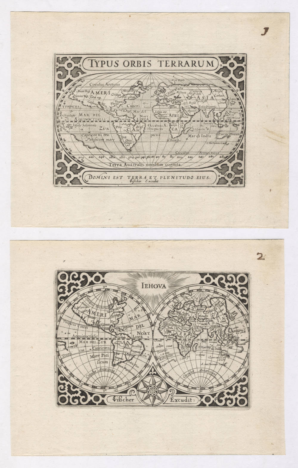
Typus Orbis Terrarum & Iehova
First Published
Amsterdam, 1649
This Edition
1649 first and only edition
Size
each 8.5 x 12.5 cms
Technique
Condition
mint
Price
This Item is Sold
Description
Lacking in every collection: the unobtainable first two atlas maps of the world to show the discovery of Tasmania. It is the first time we see these maps in the market.
Tasman's explorations were first published on Joan Blaeu's 1645-46 updated re-issue of his father Willem Blaeu wall map of the world. That wall map is known in only one example in very poor condition, in Rotterdam Maritime Museum. The Tasman results were then published again on Joan Blaeu's new wall map of the world of 1648, a map that has survived in a few examples. Both of these Joan Blaeu wall maps of the world are unobtainable, as are the two maps being offered here.
In 1649, Claes Janszoon Visscher published a pocket atlas named Tabularum Geographicarum Contractarum.
The atlas contains two maps of the world, one in oval projection and one in double hemisphere projection. The maps are revised old copperplates that had been originally engraved in 1598 by Jodocus Hondius for the Caert-Thresoor atlas of Cornelis Claesz and Barent Langenes. The 1649 publications here are updated to incorporate Tasman's discovery of Tasmania during his first voyage of 1642/43, but not his other discoveries from his first voyage (New Zealand, Fiji, etc), nor the results of his second voyage of 1644, which mapped the entite north coast of Australia. As a result, the Australian continent only has the pre-Tasman discoveries.
Visscher has removed nearly all of the hypothetical southern continent. Australia has only two toponyms, namely 't Lant van d'Eendracht for the continent and A. van Diemens Lant for Tasmania. Curiously, the world maps here show the discovery of Tasmania, but none of the other Tasman discoveries of his first voyage of 1642/43 (New Zealand, Fiji, etc) and of his second voyage of 1644 (charting the complete north coast of Australia). This suggests that Visscher either was not aware of Joan Blaeus's wall maps of the world of 1645-46 and 1648, which is unlikely, or Visscher had engraved his maps prior that.
Including the discovery of Tasmania but not of the other Tasman discoveries appears paradoxical, but is resolved with another map in Visscher's pocket atlas, one that he newly engraved and that is dedicated to Tasmania (Anthoni van Diemens Landt). Visscher must have used the detailed map by Isaac Gilsemans (map 47) because he draws attention to the first sighting of Van Diemen's Land by the crew of the Zeehaen. Apart from this, the first reference to that incident is to be found on the Blaeu 1659 Archipelagus wall map of the East Indies and Australia, so Visscher must have seen Gilsemans' original map and cannot have merely copied that of Joan Blaeu.
By 1649 Visscher was in possession of the original Langenes plates first used in 1598, which were originally owned by the Amsterdam publisher Amsterdam Cornelis Claesz, where Visscher had worked as a young apprentice. H. Laurentsz re-printed the atlas in 1609 and 1612, and the whereabouts of the copperplates is uncertain until they again appear here in 1649.
Claes Janszoon Visscher was already at a respectable age of 62 when he issued the Atlas Geographicarum Contractarum, but he knew the fifty years old maps by Langenes and Claesz very well, because at a young age he had worked as an apprentice for Cornelis Claesz (c.1551-1609), the stimulator and driving force of Dutch cartography, and who had been the publisher of the 1598 Caert Thresoor atlas.
Abel Tasman's discovery of Anthony van Diemens Land
Tasman's first expedition left Batavia on August 13th 1642, first sailing to Mauritius, and from there sailing to high southern latitudes and due east. On November 24 1642 they discover land and Abel Tasman enters in his Journal:
This land being the first land we have met with in the South Sea and not known to any European nation we have conferred on it the name of Anthony Van Diemenslandt in honour of the Honourable Governor-General, our illustrious master, who sent us to make this discovery.
Literature
Dorothy Prescott, A Little Master's Piece, The La Trobe Journal, No 79, 2007.
Günter Schilder, Australia Unveiled, pp 198-199.
Peter van der Krogt, Koeman's Atklantes Neerlandici, Volume III, map 8150:341:54.
Rarity
The Visscher miniature atlas that features these maps is only known in a handful of copies and for centuries was believed to have survived only in one single example in the British Library.
A second example of the atlas (lacking the title page) was discovered in 1986 in the State Library of Victoria by Dorothy Prescott, chief curator of the library. She published a now famous article about the atlas in 2007, describing in detail the relevance for the Tasmania and for Australia.
A third example of the atlas is now in the Chicago Newberry Library (Roger Baskes Collection). That example of the atlas lacks one of the maps of the world.
Significance
These are the first atlas maps to show the discovery of Tasmania. They are predated only by the Joan Blaeu 1645/46 and 1648 wall maps of the world, and they themselves were published ten years before the Joan Blaeu 1650 Archipelagus wall map of Australia and the East Indies, which widely disseminated knowledge of the the Tasman discoveries.
Condition description
Paper color off-white/ivory. Wide margins all around. Paper restorations, cleaning or imperfections. Dark and even impressions of the copperplate, hardly any sign sign of plate wear, which is remarkable especially for a copperplate that was over 50 years old when this imprint was made. Verso blank as called for. Pristine collector's condition.
Claes Janszoon Visscher 1587-1652
Nicolaes Visscher I (son) 1618–1679
Nicolaes Visscher II (grandson) 1649-1702
Elisabeth Visscher (widow of N. Visscher II)
Claes Jansz(oon) Visscher: A Cartographic Luminary of the Dutch Golden Age
Early Life and Apprenticeship
Claes Jansz(oon) Visscher, born on April 23, 1587, in Amsterdam, was a quintessential figure of the Dutch Golden Age, a period renowned for its flourishing culture, science, and trade. Coming from a family of artists, his father, Jan Claesz Visscher, was an engraver who likely introduced Claes to the intricacies of the craft from a young age. This early exposure to engraving and drawing under his father's mentorship laid the groundwork for Claes's illustrious career in cartography.
Claes's education in the arts was typical of the time, where young artists would apprentice under a master, learning through observation and practice. Given his family background, Claes would have had an intimate knowledge of the techniques of engraving, which was a critical skill for mapmaking during the period.
Career and Contributions
Claes Jansz Visscher's career took off in the early 17th century, a time when Amsterdam was becoming the epicenter of global trade and, consequently, cartography. Maps were not just navigational tools but also symbols of power and knowledge, reflecting the wealth and curiosity of the Dutch Republic. Visscher's maps were distinguished by their artistic embellishments, including coats of arms, allegorical figures, and scenes from mythology or daily life, which made them as much works of art as they were functional maps.
Claes Jansz. Visscher apprenticed with Cornelis Claesz., the foremost publisher of maps and pilot guides at the time. This collaboration is evidenced by several works, including maps and engravings, where Visscher's contributions are acknowledged. Visscher's apprenticeship or close working relationship with publishers like Cornelis Claesz was pivotal in shaping his career in mapmaking and engraving.
One of his early notable works was a map of the British Isles in 1616, which demonstrated his capability to blend geographical accuracy with artistic flair. This map, like many of his others, was highly sought after by collectors and navigators alike. His maps often included detailed town views, which were in vogue, providing a visual record of cities and landscapes as they appeared at the time.
The "Orbis Terrarum Typus" and Other Works
In 1638, Visscher produced one of his most celebrated works, the "Orbis Terrarum Typus," which was engraved by Pieter Goos. This map was notable for its hemispheric presentation of the world, reflecting the latest geographical knowledge while maintaining Visscher's signature decorative style.
Visscher's work also included significant contributions to regional cartography. His maps of the Netherlands were particularly detailed, reflecting the importance of accurate maps for trade and defense in a region crisscrossed by waterways and crisscrossed with political boundaries.
Legacy and Influence
Claes Jansz Visscher's influence on cartography was profound. His maps were not only used for navigation but also as status symbols, adorning the walls of the wealthy and educated. His style, characterized by detailed engraving and artistic embellishments, set a standard that influenced other cartographers of his time and beyond.
Visscher's business acumen was also noteworthy. He was not just a mapmaker but also a publisher who understood the market for cartographic products. His publications included atlases and individual maps, which were often sold in sets or bound together by purchasers, indicating a savvy approach to the market's demands.
Death and Continuation of Legacy
Claes Jansz Visscher died on June 19, 1652, in Amsterdam. His son, Nicolaes Claesz Visscher, continued the family business, maintaining the high standards set by his father. The Visscher name remained synonymous with quality in cartography for several generations, illustrating the lasting impact of Claes's work.
Conclusion
Claes Jansz Visscher's biography is not just about the life of a mapmaker but is emblematic of the Dutch Golden Age's spirit of exploration, artistry, and commerce. His maps were instruments of discovery, tools for governance, and canvases for artistic expression, making him one of the most influential cartographers of his era. Through his work, Visscher captured the world as it was known, leaving a legacy that continues to be admired for its blend of beauty and precision.
Antique Maps - A Collector's Guide
For nearly a century the members of the Visscher family were important art dealers and map publishers in Amsterdam. The founder of the business, Claes Janszoon Visscher, had premises near to those of Pieter van den Keere and Jodocus Hondius whose pupil he may have been.
From about 1620 he designed a number of individual maps, including one of the British Isles, but his first atlas consisted of maps printed from plates bought from van den Keere and issued as they stood with some additions of his own, including historical scenes of battles and sieges for which he had a high reputation.
Some maps bear the latinized form of the family name: Piscator. After Visscher's death his son and grandson, both of the same name, issued a considerable number of atlases, constantly revised and brought up to date but most of them lacking an index and with varying contents.
The widow of Nicholaes Visscher II carried on the business until it finally passed into the hands of Pieter Schenk.
(Moreland & Bannister).
Jodocus Hondius (1563-1612)
Jodocus Hondius the Younger (son) (1594-1629)
Henricus Hondius (son) (1597-1651)
Jodocus Hondius the Elder, one of the most notable engravers of his time, is known for his work in association with many of the cartographers and publishers prominent at the end of the sixteenth and the beginning of the seventeenth century.
A native of Flanders, he grew up in Ghent, apprenticed as an instrument and globe maker and map engraver. In 1584, to escape the religious troubles sweeping the Low Countries at that time, he fled to London where he spent some years before finally settling in Amsterdam about 1593. In the London period he came into contact with the leading scientists and geographers of the day and engraved maps in The Mariner's Mirrour, the English edition of Waghenaer's Sea Atlas, as well as others with Pieter van den Keere, his brother-in-law. No doubt his temporary exile in London stood him in good stead, earning him an international reputation, for it could have been no accident that Speed chose Hondius to engrave the plates for the maps in The Theatre of the Empire of Great Britaine in the years between 1605 and 1610.
In 1604 Hondius bought the plates of Mercator's Atlas which, in spite of its excellence, had not competed successfully with the continuing demand for the Ortelius Theatrum Orbis Terrarum. To meet this competition Hondius added about 40 maps to Mercator's original number and from 1606 published enlarged editions in many languages, still under Mercator's name but with his own name as publisher. These atlases have become known as the Mercator/ Hondius series. The following year the maps were re-engraved in miniature form and issued as a pocket Atlas Minor.
After the death of Jodocus Hondius the Elder in 1612, work on the two atlases, folio and miniature, was carried on by his widow and sons, Jodocus II and Henricus, and eventually in conjunction with Jan Jansson in Amsterdam. In all, from 1606 onwards, nearly 50 editions with increasing numbers of maps with texts in the main European languages were printed.
(Moreland and Bannister)
Related Categories
Related Items


