Leen Helmink Antique Maps
Antique map of Java by Visscher
The item below has been sold, but if you enter your email address we will notify you in case we have another example that is not yet listed or as soon as we receive another example.

Stock number: 19123
Zoom ImageCartographer(s)
Claes Janszoon Visscher (biography)
Title
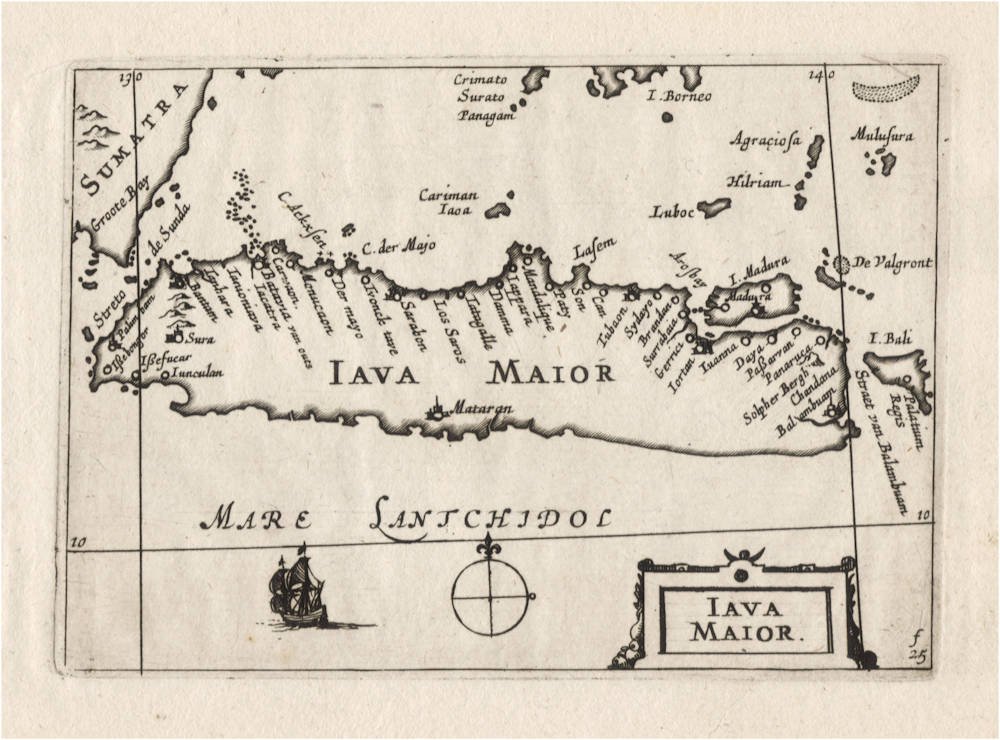
IAVA MAIOR
First Published
Amsterdam, 1649
This Edition
1649 first and only edition
Size
8.5 x 12.5 cms
Technique
Condition
mint
Price
This Item is Sold
Description
The rarest of all early maps of Java.
In 1649, Claes Janszoon Visscher publishes a pocket atlas named Tabularum Geographicarum Contractarum. The atlas is of utmost rarity and was long believed to have survived only in one single example in the British Library, until a second copy (lacking the title page) was found in the State Library of Victoria.
The atlas is so rare that it is lacking in nearly all collections. Only 3 atlas copies found on WorldCat: British Library seems to be complete, State Library Victoria (Australia) almost complete, University of Michigan, with 80 maps of Europe only.
Condition
Paper color off-white/ivory with no restorations or imperfections. Wide margins all around. A dark and even impression of the copperplate, hardly any sign sign of plate wear, especially for a copperplate that was over 50 years old when this imprint was made. Blank on verso as called for. Pristine collector's condition.
Tabularum Geographicarum Contractarum
The map was issued in 1649 in the Tabularum Geographicarum Contractarum or Atlas Contractus by the distinguished Claes Janszoon Visscher (1587-1652). In this pocket atlas, all maps appear with a signature mark in the lower right. This particular map has f.25. Such numbers are intended for the bookbinder, to instruct where and in what order to bind the maps into the atlas. Signature marks were generally printed in typeset on the verso of maps, in addition to the page number. The reason is that the bookbinder works in terms of sections or gatherings, groups of paper sheets that need to be folded, and not in terms of page numbers. Because Visscher did not add any printed text to this atlas, leaving the verso of the maps blank, he chose to engrave the signature marks in the lower right corners of the maps.
In 1649 Visscher had come into possession of the original Langenes plates first used in 1598, which were originally owned by the Amsterdam publisher Cornelis Claesz, where Visscher had worked as a young apprentice. H. Laurentsz re-printed the atlas in 1609 and 1612, and the whereabouts of those copperplates is uncertain until they again appear in 1649. Apart from the old Langenes copperplates, Visscher adds a few new maps (like this one) made by himself, as well as a few unrecorded maps that must have been made around 1598-1599 by Benjamin Wright when he (and Claes Janszoon Visscher) worked for Claesz.
Claes Janszoon Visscher was already at a respectable age when he issued the Atlas Contractus, but he knew the fifty years old maps by Langenes very well, because at a young age he had worked as an apprentice for Cornelis Claesz (c.1551-1609), who had been the stimulator and driving force of Dutch cartography, and who had been the publisher of the Langenes atlas.
It is possible that Visscher had already acquired the Langenes copperplates at the famous 1610 auction of the stock of books, maps, prints and copperplates of his former employer Cornelis Claesz. Never before had the Dutch Republic witnessed an auction of books and prints and copperplates of comparable scale.
According to Peter van der Krogt (New Koeman Volume III), no more than 8 copies of the atlas are known, of which only 6 are complete.
Reference: van der Krogt Koeman's Atklantes Neerlandici, Volume III, map 8150:341:54.
Claes Janszoon Visscher 1587-1652
Nicolaes Visscher I (son) 1618–1679
Nicolaes Visscher II (grandson) 1649-1702
Elisabeth Visscher (widow of N. Visscher II)
Claes Jansz(oon) Visscher: A Cartographic Luminary of the Dutch Golden Age
Early Life and Apprenticeship
Claes Jansz(oon) Visscher, born on April 23, 1587, in Amsterdam, was a quintessential figure of the Dutch Golden Age, a period renowned for its flourishing culture, science, and trade. Coming from a family of artists, his father, Jan Claesz Visscher, was an engraver who likely introduced Claes to the intricacies of the craft from a young age. This early exposure to engraving and drawing under his father's mentorship laid the groundwork for Claes's illustrious career in cartography.
Claes's education in the arts was typical of the time, where young artists would apprentice under a master, learning through observation and practice. Given his family background, Claes would have had an intimate knowledge of the techniques of engraving, which was a critical skill for mapmaking during the period.
Career and Contributions
Claes Jansz Visscher's career took off in the early 17th century, a time when Amsterdam was becoming the epicenter of global trade and, consequently, cartography. Maps were not just navigational tools but also symbols of power and knowledge, reflecting the wealth and curiosity of the Dutch Republic. Visscher's maps were distinguished by their artistic embellishments, including coats of arms, allegorical figures, and scenes from mythology or daily life, which made them as much works of art as they were functional maps.
Claes Jansz. Visscher apprenticed with Cornelis Claesz., the foremost publisher of maps and pilot guides at the time. This collaboration is evidenced by several works, including maps and engravings, where Visscher's contributions are acknowledged. Visscher's apprenticeship or close working relationship with publishers like Cornelis Claesz was pivotal in shaping his career in mapmaking and engraving.
One of his early notable works was a map of the British Isles in 1616, which demonstrated his capability to blend geographical accuracy with artistic flair. This map, like many of his others, was highly sought after by collectors and navigators alike. His maps often included detailed town views, which were in vogue, providing a visual record of cities and landscapes as they appeared at the time.
The "Orbis Terrarum Typus" and Other Works
In 1638, Visscher produced one of his most celebrated works, the "Orbis Terrarum Typus," which was engraved by Pieter Goos. This map was notable for its hemispheric presentation of the world, reflecting the latest geographical knowledge while maintaining Visscher's signature decorative style.
Visscher's work also included significant contributions to regional cartography. His maps of the Netherlands were particularly detailed, reflecting the importance of accurate maps for trade and defense in a region crisscrossed by waterways and crisscrossed with political boundaries.
Legacy and Influence
Claes Jansz Visscher's influence on cartography was profound. His maps were not only used for navigation but also as status symbols, adorning the walls of the wealthy and educated. His style, characterized by detailed engraving and artistic embellishments, set a standard that influenced other cartographers of his time and beyond.
Visscher's business acumen was also noteworthy. He was not just a mapmaker but also a publisher who understood the market for cartographic products. His publications included atlases and individual maps, which were often sold in sets or bound together by purchasers, indicating a savvy approach to the market's demands.
Death and Continuation of Legacy
Claes Jansz Visscher died on June 19, 1652, in Amsterdam. His son, Nicolaes Claesz Visscher, continued the family business, maintaining the high standards set by his father. The Visscher name remained synonymous with quality in cartography for several generations, illustrating the lasting impact of Claes's work.
Conclusion
Claes Jansz Visscher's biography is not just about the life of a mapmaker but is emblematic of the Dutch Golden Age's spirit of exploration, artistry, and commerce. His maps were instruments of discovery, tools for governance, and canvases for artistic expression, making him one of the most influential cartographers of his era. Through his work, Visscher captured the world as it was known, leaving a legacy that continues to be admired for its blend of beauty and precision.
Antique Maps - A Collector's Guide
For nearly a century the members of the Visscher family were important art dealers and map publishers in Amsterdam. The founder of the business, Claes Janszoon Visscher, had premises near to those of Pieter van den Keere and Jodocus Hondius whose pupil he may have been.
From about 1620 he designed a number of individual maps, including one of the British Isles, but his first atlas consisted of maps printed from plates bought from van den Keere and issued as they stood with some additions of his own, including historical scenes of battles and sieges for which he had a high reputation.
Some maps bear the latinized form of the family name: Piscator. After Visscher's death his son and grandson, both of the same name, issued a considerable number of atlases, constantly revised and brought up to date but most of them lacking an index and with varying contents.
The widow of Nicholaes Visscher II carried on the business until it finally passed into the hands of Pieter Schenk.
(Moreland & Bannister).


