Leen Helmink Antique Maps
First facsimiles of Waldseemüllers wall maps of 1507 and 1516
The item below has been sold, but if you enter your email address we will notify you in case we have another example that is not yet listed or as soon as we receive another example.

Stock number: 19060
Zoom ImageDescription
Jos.f Fischer und Fr. R. von Wieser: Die älteste Karte mit dem Namen Amerika aus dem Jahre 1507 und die Carta Marina aus dem Jahre 1516 des M. Waldseemüller (Ilacomilus) / The oldest map with the name America and the carta marina of the year 1516 by M. Waldseemüller (Ilacomilus). Grand-folio. Green halfleather with gold title. Innsbruck, 1903.
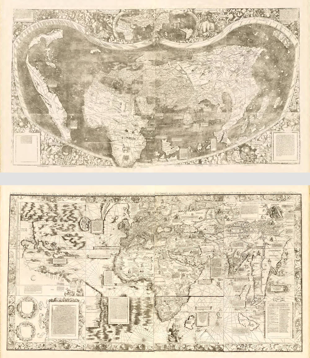
The first and best reproductions of the two monumental wall maps by Martin Waldseemüller (1470-1521), originally published in 1507 and 1516. Both are reproduced here life size in the photolithograph of 1903 by the Jesuit historian and cartographer Joseph Fischer, who found the only surviving examples in the library of Wolfegg Castle in Württemberg in 1901.
The existence of these wall maps was known from Renaissance sources, but no examples were known until Fisher found examples in a Sammelband (Collective Volume) that had belonged to the German cartographer and globemaker Johann Schoner (1477-1547).
The re-discovery of these long lost wall maps is considered the most important cartographical discovery of modern times.
The Sammelband originally contained the 1507 Waldseemüller map, the 1516 Waldseemüller Carta marina, a set of celestial gores by Schöner from around 1517, and the Dürer-Stabius star chart. When the volume was disbound in 1905 by Father Joseph Fischer in order to make facsimiles of the two Waldseemüller maps, he found, in the binding, fragments of celestial and terrestial globe gores by Schöner. These fragmentary gores were mounted on paper and bound in the Sammelband.
The wall map of 1507 is now in the collection of the Library of Congress in Washington D.C., who in 2001 got permission from the German government to purchase the map for ten million US dollars.
The 1507 wall map of the world is the first map to use the name America, erroneously honouring the Italian Amerigo Vespucci who claimed that he had discovered the New World. Waldseemuller tried to correct his mistake in his later maps, but in vain, the name would stick.
The wall map of 1516 is also in the Library of Congress collection.
The 1516 wall map of the world is the first to show Mecca and Medina.
The facsimile offered here, in Grand-Folio format, is the original edition of 1903 by Joseph Fisher that is lacking in nearly all collections (there is a later edition from 1968 that is more commonly found).
The facsimile contains Fishers elaborate description and analysis of the Sammelband and the wall maps, and an overview of all the evidence for the identification as these being Waldseemuller's long lost wall maps, which was necessary because the maps themselves are not signed by the great cartographer.
But the most desirable part of the facsimile are the life size reproductions of the wall maps.
See this complete page by page overview of this exceptionally rare and important facsimile edition in the Getty Research Institute.
Preface of this facsimile work
Herewith two old cartographic works which have long been sought for in vain and which are of monumental importance for the history of cartography and the era of discoveries are given over to publicity: the two large maps of Waldseemüller of the years 1507 and 1516.
The only original prints which have up to the present become known are preserved in the library of Prince Waldburg-Wolfegg at the castle of Wolfegg in Württemberg. There they were recently discovered, bound in a collective volume, by J. FISCHER.
His serene highness PRINCE FRANCIS OF WALDBURG-WOLFEGG graciously gave us permission to publish the two precious maps, whereby he has placed not only us but all interested scientific circles under the greatest obligations, quod ea res — to use the words of Waldseemüller — communi rei litterariae proderit.
The photolithographic reproductions of the maps were made in the well-known art-institute of O. CONSÉE at Munich with most painstaking exactitude.
Our plates render the originals most faithfully together with all their accidentals and errors, accurate to the millimeter. All retouching was excluded on principle, so that the plates here offered can be called facsimiles in the strict sense of the term. If in joining the single sheets the coincidence of the lines leaves something to be desired, this is owing entirely to the original woodcuts.
In spite of these small differences and inequalities, the two maps of the world precisely as total views justly arouse our admiration. The problem of producing large maps consisting of several sheets by means of the wood-engravers art appears solved in a surprisingly happy manner for those days. So far as we can perceive the map of the world of the year 1507 exhibits quite the first example of the production of a large woodcut in so many plates.
We judged it advisable, or rather necessary, to supplement our reproduction of the 24 plates of Waldseemüller with general views of the two maps of the world. In carrying out this plan we had to consider from what point of view we had best make the single sheets tally. By laying the principal weight on the coincidence of the contours of the lands and the chief lines of direction (equator and tropics) we believe we have obtained a suitable general view which is sufficiently clear in spite of its small scale.
(Fischer and Wieser)
Martin Waldseemüller (c.1470-1518)
Waldseemüller, born in Radolfzell, a village on what is now the Swiss shore of Lake Constance, studied for the church at Freiburg and eventually settled in St Dié at the Court of the Duke of Lorraine, at that time a noted patron of the arts. There, in the company of likeminded savants, he devoted himself to a study of cartography and cosmography, the outcome of which was a world map on 12 sheets, now famous as the map on which the name “America’ appears for the first time. Suggested by Waldseemüller in honour of Amerigo Vespucci (latinised: Americus Vesputius) whom he regarded, quite inexplicably, as the discoverer of the New World, the new name became generally accepted by geographers before the error could be rectified, and its use was endorsed by Mercator on his world map printed in 1538. Although only one copy is now known of Waldseemüller's map and of the later Carta Marina (1516) they were extensively copied in various forms by other cartographers of the day.
Waldseemüller is best known for his preparation from about 1507 onwards of the maps for an issue of Ptolemy's Geographia, now regarded as the most important edition of that work. Published by other hands in Strassburg in 1513, it included 20 ‘modern' maps and passed through one other edition in 1520. Four more editions on reduced size were issued of the Laurent Fries version.
It remained the most authoritative work of its time until the issue of Münster's Geographia in 1540 and Cosmographia in 1544.
(Moreland and Bannister)
Related Categories
Related Items


 by Ruscelli")


