Leen Helmink Antique Maps
Willem Lodewijcksz forbidden Chart of Java
The item below has been sold, but if you enter your email address we will notify you in case we have another example that is not yet listed or as soon as we receive another example.

Stock number: 19019
Zoom ImageCartographer(s)
Willem Lodewijcksz (biography)
Title
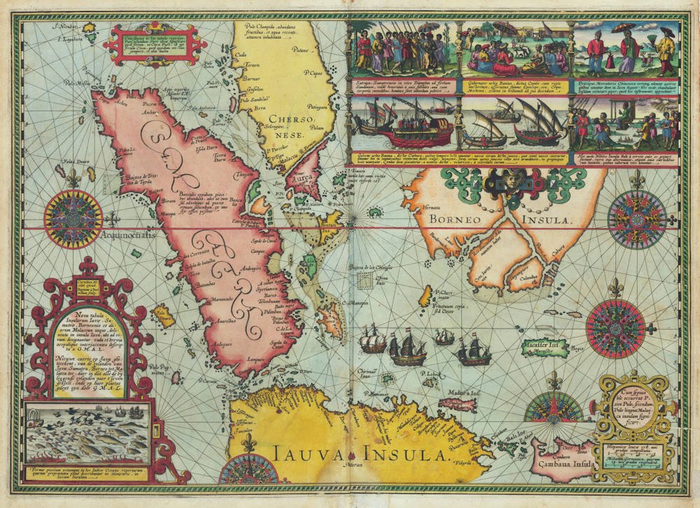
Nova tabula, Insularum lavæ, Sumatræ, Borneonis et aliarum Malaccam usque, delineata in insula Iava, ubi ad vivum designantur vada et brevia scopulique interjacentes descripta a G.M.A.L.
First Published
Amsterdam, 1598
This Edition
1598
Size
38.0 x 54.0 cms
Technique
Condition
excellent
Price
This Item is Sold
Description
The missing map of the arrival of the Dutch First Fleet
The forbidden map of the Indies printed by Cornelis Claeszoon, Amsterdam 1598
An exceptionally rare, magnificent and highly important sea chart, adjourned with five dramatic compass roses, three strapwork cartouches, and a total of seven scenes depicting the adventures of the fleet. The descriptions on the map are in Latin, with the title repeated in Dutch.
Lodewijcksz sea chart of Indonesia was made from live observations on the Dutch First Fleet voyage to the Indies 1595-97, and was intended to be included in his journal of the voyage that would be published soon after return.
“Here follows the chart of Java:” – But there is no map. In fact, there never is.
The dreams and labours of Petrus Plancius and Jan Huyghen van Linschoten culminated in the Dutch First Fleet to the Indies taking place from 1595 to 1597. It was instrumental in the opening up of the Indonesian spice trade to the merchants that would soon form the United Dutch East India Company (VOC). This famous pioneering voyage, commanded by Cornelis de Houtman, would abruptly end the Portuguese Empire´s trade monopoly for the East and it would dramatically change the Indian Ocean theatre, notably the balance of power and the rules of trade. Right from this first voyage onward, the Dutch were going to dominate the East Indies and its trade for more than 200 years, and the Dutch were to stay in the area for more than 350 years.
Already in 1598, shortly after the return of the first fleet, the Amsterdam publisher Cornelis Claesz published an acclaimed account of the first voyage, in Dutch and in Latin. The account was written by Willem Lodewijcksz, an officer on the fleet. The book was an instant success that sold in many editions and was translated in several languages. The book explicitly refers to this map to be included (at the end of Chapter 18: “Here follows the chart of Java and Sumatra”). But the map is never there. Indeed, no copy of any edition of the book is known to have the map, evidently because it was immediately forbidden, and already printed copies destroyed.
Condition
A dark and even imprint of the copperplate. Stunning original colour. Excellent condition.
Willem Lodewijcksz
Willem Lodewijcksz was a Dutch naval officer and author, known for his detailed account of the first Dutch expedition to the East Indies from 1595 to 1597. This pioneering voyage, led by Cornelis de Houtman, marked the beginning of Dutch involvement in the spice trade and the establishment of the Dutch East India Company (VOC).
Lodewijcksz's journal, titled D'eerste boeck: Journal ofte beschrijvinghe van de reyse gedaen by de Hollandtsche schepen, provides a comprehensive narrative of the expedition. It offers insights into the challenges faced during the journey, interactions with local populations, and observations of the regions visited. His work is considered one of the earliest and most valuable Dutch accounts of Southeast Asia.
While specific personal details about Lodewijcksz are scarce, his contributions as a chronicler have been instrumental in understanding early Dutch maritime exploration and the subsequent expansion into the East Indies.
We do know from his own journal and from other sources that he was well educated in navigation and in commerce, and that he was fluent in Spanish, Portuguese and Italian.
He was important enough to take part in the ship's councils during the expedition, and was part of commercial and navigational decisions.
Possibly worried about repercussions for spreading secret information, the journal's author is named only as "G.M.A.W.L.", which was only centuries later deciphered as G(uillaume) M(..) A(lias) W(illem) L(odewycksz).
Interestingly, he was added to the fleet at the very last minute, on the day it was sailing, after it had already spent 10 days of waiting for favourable winds at Texel roadstead. He was added by the Amsterdam faction venture capitalist investors of the fleet, as an "Adelborst", a gentleman officer. These were the well educated young sons of successful citizens brave enough to risk their lives for a steep career in commerce and navigation.
As IJzerman notes:
On the final day of the ships' stay, Saturday, April 1, 1595, so to speak, at the very last moment, Lodewycksz came aboard the Amsterdam. He was accompanied by "some" of the shipowners (who exactly?) and had traveled from Amsterdam to Texel on Wednesday, March 29. The ships had already been anchored there since March 21, while some cadets, including Van der Does, had also traveled overland to Texel on Easter Sunday, March 26.
At the very last moment, Lodewycksz was extraordinarily appointed to the ship bearing the name of the departing Amsterdam. As evidenced by his entire First Book, he acted as a "mediator" between the factions that were noticeable from the very beginning: those on the Mauritius, the Prince's ship, led by Cornelis de Houtman as the senior merchant, and those on the Hollandia, the States' ship, where Houtman's fierce rival Gerrit van Boninghen served as merchant.
Lodewycksz was able to participate in the entire voyage and, in the end, omitting or glossing over all disputes, was able to write the official account of the First Expedition on behalf of the Amsterdam shipowners.


