Leen Helmink Antique Maps
Antique map of Australia and South East Asia by de Bry


Stock number: 18926
Zoom ImageCartographer(s)
Theodore de Bry (biography)
Title
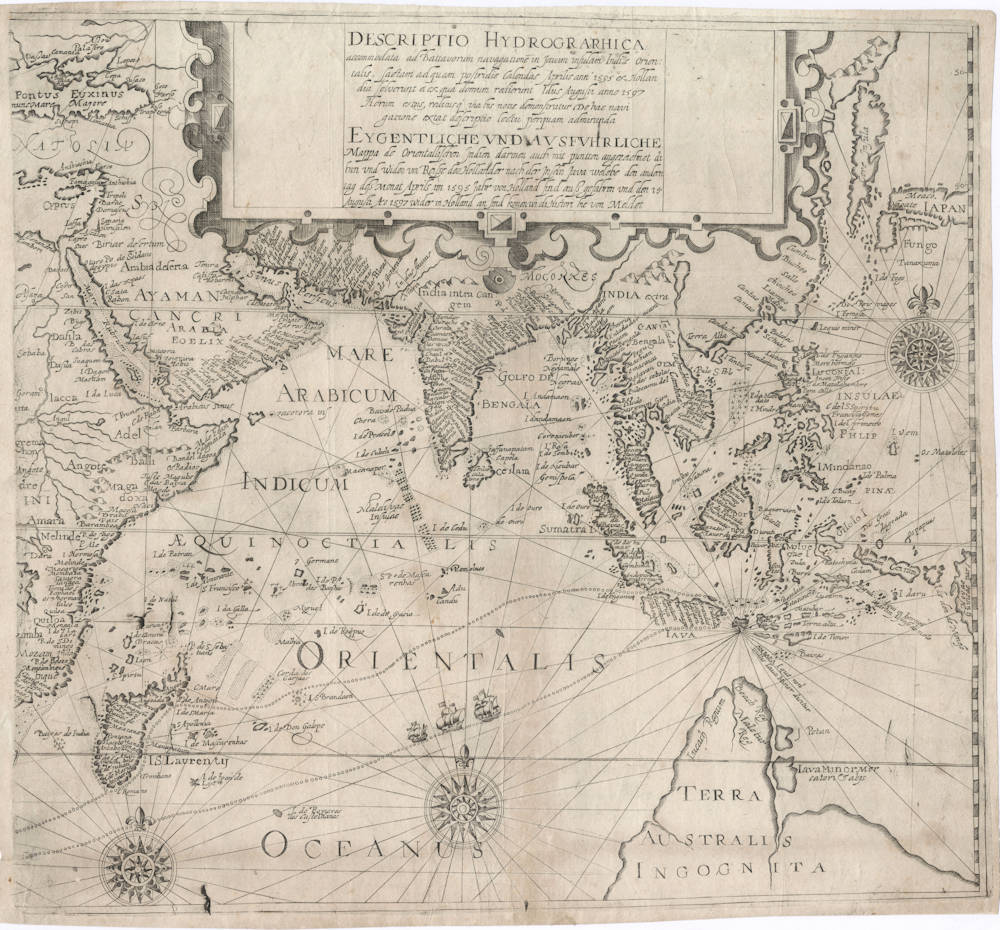
Descriptio Hydrographica accomodata ad Battavorum navigatione in Javam insulam Indiae Orientalis
First Published
Frankfurt, 1599
This Edition
1599
Size
35 x 38 cms
Technique
Condition
excellent
Price
This Item is Sold
Description
Enter the Dutch
Theodor de Bry's map of the voyage of the first Dutch fleet to the East Indies in 1595-97, published in his rare 1599 "Peregrinationum in Indiam Oriental et Indiam Occidentales", Petits Voyages, Part III.
The map is copied from a very rare separately issued map of Cornelis Claesz depicting the route of the first voyage.
Theodore de Bry repackaged and republished chronicles of contemporary voyages to reach a wider audience than the original accounts had. His adaptation of Cornelis Claesz' map is particularly important since the original was quickly prohibited from publication by the Dutch authorities, and thus would have otherwise been known only to a small circle of privileged insiders. But Theodor de Bry had managed to get his hands on an example of that "forbidden" map, and renders it here accurately in a reduced size.
Condition
Eastern map of two companion maps, depicting the track of the first Dutch fleet to the East Indies. This map covers the Indian Ocean and the Far East, and is the most desirable and sought after. Offered here without the companion map that covers the fleet's track in the Atlantic Ocean. No restorations or imperfections. Good margins all around. Some folds as issued. Overall a very authentic and handsome example in excellent collector's condition.
The Dutch First Fleet to the Indies 1595-97
The dreams and labours of Petrus Plancius and Jan Huyghen van Linschoten culminated in the Dutch First Fleet to the Indies taking place from 1595 to 1597. It was instrumental in the opening up of the Indonesian spice trade to the merchants that would soon form the United Dutch East India Company (VOC). This famous pioneering voyage, commanded by Cornelis de Houtman, would abruptly end the Portuguese Empire ́s trade monopoly for the East and it would dramatically change the Indian Ocean theatre, notably the balance of power and the rules of trade. Right from this first voyage onward, the Dutch were going to dominate the East Indies and its trade for more than 350 years.
In April 1595, a group of Amsterdam merchants dispatched a fleet of four ships to explore the route around the Cape of Good Hope to establish a firm base for the spice trade in the Far East, breaking the Portuguese monopoly.
The fleet left with a crew of 249 in total, under command of Cornelis de Houtman. By the time the fleet returned in August 1597, only 89 men had survived. The investments barely broke even. Nevertheless, the voyage demonstrated that it was possible to sail for the spices in Asia and breaking the Portuguese/Spanish monopoly and presumed invincibility. This trade and the sea route had been under control of the Portuguese for a century, but would be taken over completely by the Dutch within a few years. The gloves were off.
Cornelis de Houtman used maps that had been prepared by Petrus Plancius, and sailing instructions and trading knowledge that had been carefully collected by Jan Huyghen van Linschoten, a Dutchman who spent a long time in Portuguese service and published his findings in his Itinerario, an encyclopedia of knowledge about the Portuguese in the Far East.
An overview of the route taken by this fleet was published by Cornelis Claesz in 1598 in Amsterdam, but all printed copies of this map were immediately confiscated by the Dutch Republic for reasons of secrecy. This "forbidden" map has survived in three examples only. Fortunately it was copied by Theodor de Bry.
The Dutch were the first to enter the archipelago through Sunda Strait by crossing the Indian Ocean, instead of the coastal monsoon routes that the Portuguese took. This approach had been recommended by Linschoten, because it was shorter and reduced the risk to run into hostilities with the Portuguese. It was quite a navigation achievement to accurately hit such a small target coming from Madagascar, with only open water and no landmarks in between. Fortunately the volcano of Krakatau [Krakatoa] in Sunda Strait was a 2750 feet tall orientation point at the time (before the 1883 eruption the summit was much higher than after the eruption).
The map is based on the latest Portuguese sources, combined with the discoveries of the Dutch during this voyage, and is of particular significance for the mapping of the Indian Ocean, of South East Asia in general, and of Malaysia, and Indonesia. The Philippines (INSULAE PHLIPPINAE) are depicted in remarkable detail.
It also shows a large TERRA AUSTRALIS INCOGNITA ["Unknown South Land"] in the lower right. The toponyms can be traced back to Marco Polo. Interestingly, from the map it is obvious that the Dutch would not be surprised in 1616 (Dirck Hartogsz) to run into the coast of Western Australia, it was undiscovered but expected.
Both the forbidden map itself, as well as the copy by de Bry, and the first voyage itself, are extensively researched and described by Prof Schilder in his Monumenta Cartographica Neerlandica, Vol VII, chapter XI, pp 229-277.
This event of the first Dutch fleet to the Far East was the first in a series that was going to change the African, Asian, and Australian theater for more than 350 years to come. It led to the founding of the Dutch East India Company a few years later.
A most rare and seminal collector's item.
Theodore de Bry (c.1527-1598)
De Bry was an engraver, bookseller and publisher, active in Frankfurt-am-Main, who is known to have engraved a number of charts in Waghenaer’s The Mariners Mirrour published in London in 1588. In that same year, also in London, an account was published by Thomas Hariot, illustrated by the artist John White, describing Raleigh's abortive attempt to found a colony in Virginia, and this was to be the inspiration for de Bry's major work, the series of Grands Voyages and Petits Voyages. In all, 54 parts of these two works were issued containing very fine illustrations and beautiful, and now very rare, maps, much sought after by collectors.
(Moreland and Bannister)
Related Categories
Antique maps of the East India Company
Antique maps of Australia
Antique maps of Japan
Antique maps of China
Antique maps of the Philippines
Antique maps of Southeast Asia
Antique maps of India and Ceylon
Antique maps of Korea
Antique maps of the Middle East
Antique maps of Asia
Antique maps of Africa
Old books, maps and prints by Theodore de Bry


