Leen Helmink Antique Maps
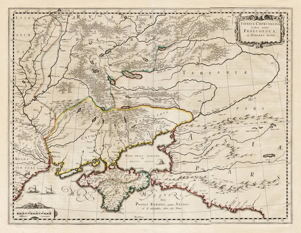
Antique map of Crimea by Blaeu

Stock number: 18888
Zoom ImageCartographer(s)
Willem Janszoon Blaeu (biography)
Title
Taurica Chersonesus, Nostra aetate Przecopsca, et Gazara dicitur.
First Published
Amsterdam, 1634
This Edition
1642
Size
38 x 50 cms
Technique
Condition
excellent
Price
$ 395.00
(Convert price to other currencies)
Description
Willem Janszoon Blaeu's fine map of modern day Ukraine, the Crimea, and southern Russia, including Moscow and Smolensk. The map first appeared in Blaeu's 1634 German edition of the Atlas Appendix, his first international atlas.
Taurica, Tauric Chersonese, and Taurida were names by which Crimea was known to the Greeks and Romans. According to Greek legends, the Tauri were the people among whom Iphigeneia was sent after the goddess Artemis rescued her from the human sacrifice her father was about to perform: she became a priestess at the goddess's temple in the land of the Tauri, where she was forced by the king Thoas to sacrifice any foreigners who came ashore.
The Tauric Chersonese was inhabited by a variety of people. The inland regions were inhabited by Scythians and the mountainous south coast by the Tauri, an offshoot of the Cimmerians.
Greek settlers had a number of colonies along the coast of the peninsula, notably the city of Chersonesus near modern Sevastopol. Taurica was a vassal state of the Romans for nearly five centuries, and the southern shores remained under Byzantine control until the AD 13th century.
The peninsula later became generally known by the name used for it by the Crimean Tatars. The word "Crimea" comes from the Crimean Tatar name Qirim, via Greek Krimeia.
(Joppen).
Ref: van der Krogt [1890:2]
Willem Janszoon Blaeu (1571-1638)
Joan Blaeu (son) (1596-1673)
Cornelis Blaeu (son) (?-c.1642)
Willem Jansz. [Blaeu] and his son Joan are the most widely known cartographic publishers of the seventeenth century. Born as the son of a wealthy herring merchant in Alkmaar North Holland, to Anna, a first cousin of Willem. Cornelis Hooft was merchant in oil, grain and herring and twelve times mayor of Amsterdam. He hoped that Willem would take over his business.
But Willem was more interested in mathematics, astronomy and other scientific matters, however, and in 1595 he left for Denmark to study with the astronomer Tycho Brahe on the island of Ven. Brahe had established here his own observatory as well as a workshop for the manufacturing of instruments and a printing office. This enabled young Willem to acquire both theoretical and practical knowledge and provided him with contacts among like-minded people. After his return to the Netherlands he applied himself to astronomy for several years in his native Alkmaar. Here he published his first cartographic work: a celestial globe according to the observations of Tycho Brahe.
At the end of the sixteenth century Willem Jansz. moved with his family to Amsterdam. He set up a shop in celestial and terrestrial globes and nautical instruments, since the rapid growth of seafaring opened a large market for these goods. Soon he was able to offer for sale globes in various sizes. In 1605 Willem Jansz. moved to a new location at the "Op ‘t Water" (today Damrak nr. 46), a house with the sign of in de Vergulde Sonnewijwyser ("in the Gilded Sundial"). Apart from the manufacturing globes, Willem Jansz. published numerous maps and charts in folio size, along with multi-sheet wall maps, town views, and historical prints, all of which are now very rare.
Willem Jansz. made an unmatched contribution to the fields of navigation and cartography. His "Het Licht der Zee-vaert", published in 1608, was of great consequence for navigation in European coastal waters. He used the same oblong-size like Waghenaer did in his "Thresoor der Zeevaert" (1592): the work was constructed in a series of chapters, adding to each chapter sailing-descriptions for a specific stretch of coast and the corresponding chart. The coastal profiles in woodcut have been included in the text of each chapter.
In 1618 another mapmaker, bookseller and publisher, Jan Jansz. (Joannes Janssonius) established himself on the Damrak next door to Willem Jansz.’s shop. Accusing each other of copying and stealing information, the neighbours became fierce competitors. In about 1621, Willem Jansz. decided to put an end to the confusion between his name and his competitor’s and assumed his grandfather’s sobriquet, (Blauwe Willem), as the family name; thereafter he called himself Willem Jansz. Blaeu.
Responding to Janssonius’s plagiarism of "Het Licht der Zeevaert", Blaeu published a new pilot-guide in 1623: the "Zeespiegel", a description of the seas and coasts of the Eastern, Northern and Western Navigation. Approximately the same coastal areas are described as in the older "Het Licht der Zeevaert", but in a much more elaborate way and with a far greater number of charts.
Apart from pilot-guides, Blaeu also published single-sheet charts, often printed on durable vellum. As example attention is here given to the so-called "West-Indische Paskaert", a chart of the Atlantic Ocean in Mercator’s projection, published about 1630. Despite the obvious advantages for navigation, the charts drawn on this projection were only gradually accepted by navigators.
Blaeu was nearing the age of sixty when in 1630 he published his first atlas of the world and began to compete with Henricus Hondius. For many years Blaeu toyed with the idea of publishing his own atlas of the world. The initial material for an atlas was in Blaeu’s hands in the form of his own folio-maps, which he had begun publishing in 1604. Blaeu’s plan gained momentum, however, when he succeeded in 1629 in purchasing a large number of copperplates that had belonged to the late Jodocus Hondius the younger. Blaeu quickly amended these plates by replacing Hondius’s name with his own imprint, a common procedure in those days. In 1630 Blaeu published the "Atlantis Appendix", using his own maps and the amended maps of Jodocus Hondius. The world atlas consists of 60 maps, but without a descriptive text. In 1631 a new world atlas was published , titled "Appendix Theatri A. Ortelii et Atlantis G. Mercatoris", provided with a Latin text and nearly hundred maps. The intention in publishing this atlas was to produce a supplement to the works of the two famous geographers. Henricus Hondius and his brother-in-law Joannes Janssonius immediately took steps in reaction to the publication of Blaeu’s "Appendix" and published amended atlas-publications.
The fierce competition between Blaeu and Hondius-Janssonius greatly influenced the further development of their atlas productions. Blaeu now intended to distance himself completely from Ortelius and Mercator and to publish an entirely new world atlas in four languages. In 1634 a German edition was published, which contains a number of unfinished maps, a sign that the work was done hurriedly in order to have the atlas published in time.
The extent of Blaeu’s ambitious plans for the world atlas is reflected in his preface, where he states that it is his intention to describe the whole world and to depict all the ports and seas, and therefore several other volumes of the atlas were to follow shortly. In view of these plans, Blaeu’s investment in a new printing shop in 1637 is not surprising. Yet Blaeu did not live to see the publication of a new volume. After his death the business was continued by his two sons Joan and Cornelis, the elder of whom had been collaborating on the atlas since 1631. In 1640 a third volume was published (Italy), in 1645 a fourth (England and Wales), in 1654 a fifth (Scotland) and finally in 1655, a sixth volume covered China.
In addition to his activities as publisher, Willem Jansz. Blaeu continued his scientific pursuits. His expertise won official recognition at his appointment as chart maker and examiner of navigating officers by the Amsterdam Chamber of the United Dutch East India Company (VOC).
Blaeu’s new position gave him access to the enormous map archives of the VOC. He performed the function of chart maker until his death in 1638. For his task he employed the four assistants of his deceased predecessor Hessel Gerritsz. Blaeus’s work was most probably limited – given his age – to the supervision of his employees in the manufacture of charts, to the supervision of content and to any alterations and improvements required. A steady stream of charts, required to equip the ships, must have left his workshop. Thanks to his position as chart maker of the VOC, Blaeu was able to expand his world atlas of Asia with new maps and gain the edge on his Amsterdam competitors, Hondius and Janssonius.
Willem Jansz. Blaeu died in October 1638, leaving his prospering business to his sons, Joan and Cornelis.
(Schilder)
Related Categories
Related Items


 by Gastaldi / Ptolemy")
