Leen Helmink Antique Maps
Antique map of Far East, Australia, Indian Ocean by van Keulen


Stock number: 18695
Zoom ImageCartographer(s)
Johannes van Keulen (biography)
Title
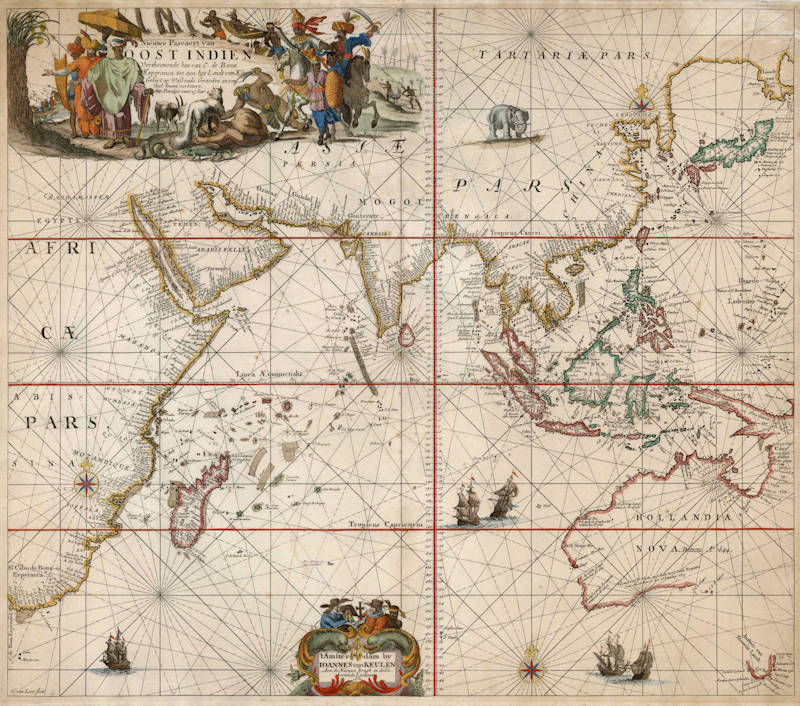
Nieuwe Pascaert van Oost Indien
First Published
Amsterdam, 1680
This Edition
1680 first edition first state
Size
51.1 x 59.0 cms
Technique
Condition
excellent
Price
This Item is Sold
Description
Title cartouche
Nieuwe Pascaert van OOST INDIEN
[ "New Navigation chart of the EAST INDIES" ]
Verthoonende hen van C. de Bona Esperanca tot aen het Landt van Eso
[ "Showing them from the Cape of Good Hope up to the Land of Jeso (Hokkaido)" ]
Geleyt op Waßende Graeden en van Veel fouten verbetert.
[ "Drawn on Increasing Degrees (of latitude, so Mercator's projection) and with many errors corrected." ]
Met Priviligie voor 15 Iaar.
[ "With Privilige (copyright from the Dutch States General) for 15 Years." ]
The title cartouche is decorated with people and animals of the shown areas. It is famous for the decapitation scene.
Address cartouche
't Amsterdam by IOANNES van KEULEN
[ "(published in) Amsterdam by JOHANNES van KEULEN" ]
Aen de Nieuwe brugh in de Gekroonde Lootsman 1680
[ "At the New bridge in the Crowned Steersman 1680" ]
The address cartocuhe is flanked by two large fish, holding the Golden Fleece, representing the riches imported from the east. It is topped by four characters, three Dutch and a local from the Indies. Of the three Dutch, the left one is a pilot, with a chart, a pair of dividers, and a Jacob's staff, all essential navigational instruments. The person next to him looking at him in admiration represents a common sailor. To his right we see a merchant, wearing wealthy clothing including a ruff or "millstone collar".
This is one of the most desirable navigation charts of the East Indies and Australia, published by Johannes van Keulen in Amsterdam. The map stretches from Cape of Good Hope to Japan, and from the Red Sea to Tasmania. Two decorative cartouches, the large one showing the splendour and richness of the East. Decorated with many ships, rhumb lines, compass roses. It covers all of the waters of the monopoly charter of the Dutch East India company, all the way from the Cape of Good Hope to Japan. It covers all of the Indian Ocean, as well as the waters from Batavia to Japan.
"This is an extremely decorative sea chart showing the Cape of Good Hope, the east coast of Africa, Arabia, India, Japan and the Far East, with the western half of Hollandia Nova (Australia)."
(Norwich).
"A colorful animated cartouche with a back view of a large bushy fat tailed sheep in the foreground ... [and] a rather gruesome decapitation."
(Tooley).
Condition
Here in the very rare first copperplate state of 1680. First 1680 edition. Dark and even imprint of the copperplate. Printed on thick paper, for use at sea. Margins all around. No restorations or imperfections. Attractive hand colouring, in the correct style of the period. Heightened in gold. Excellent collector's condition.
Johannes van Keulen (1654-1711)
Gerard van Keulen (son) (1678-c.1727)
Johannes van Keulen II (grandson) (active 1726-1755)
The Dutch produced a remarkable number of enterprising and prolific map and chart makers but not even the Blaeu and Jansson establishments could rival the vigour of the van Keulen family whose business was founded in 1680 and continued under their name until 1823 and in other names until 1885 when it was from wound up and the stock dispersed at auction.
Throughout the history of the family, the widows several of the van Keulens played a major part, after their husbands' deaths, in maintaining the continuity of the business. The firm was founded by Johannes van Keulen who was registered as a bookseller in Amsterdam in 1678. In 1680 he published the first part of his 'Zee Atlas' which, over the years, was expanded to 5 volumes and continued in one form or another until 1734. More ambitious and with a far longer and more complicated life was his book of sea charts, the 'Zee-Fakkel', first published in 1681–82, which was still being printed round the year 1800. A major influence in the development of the firm was the acquisition in 1693 of the stock of a rival map publisher, Hendrik Doncker.
Although the firm was founded by Johannes van Keulen, he was primarily a publisher; it was his son, Gerard, a talented engraver, mathematician, Hydrographer to the East India Company, who became mainspring of the business which not only published charts but also books on every aspect of geograpy, navigation and nautical matters,
(Moreland and Bannister)
It was grandson Johannes van Keulen (II) who in 1753 produced Volume VI of the Zee-Fakkel for the VOC East Indiamen, containing printed charts for the navigation covering the waters from the Cape of Good Hope to Nagasaki . The atlas was not commercially sold and only for use on board of VOC ships, therefore it is also refered to as the 'secret atlas' odf the VOC. The engraving quality and craftmanship surpasses that of all earlier printed sea charts.
Sea charts from the secret atlas are among the rarest and most desirable sea charts for collectors.
Related Categories
Antique maps of the East India Company
Antique maps of Australia
Antique maps of Japan
Antique maps of China
Antique maps of the Philippines
Antique maps of Southeast Asia
Antique maps of India and Ceylon
Antique maps of Korea
Antique maps of the Middle East
Antique maps of Asia
Antique maps of Africa
Old books, maps and prints by Johannes van Keulen


