Leen Helmink Antique Maps
Antique map of East Coast by Gastaldi
The item below has been sold, but if you enter your email address we will notify you in case we have another example that is not yet listed or as soon as we receive another example.

Stock number: 18666
Zoom ImageCartographer(s)
Giacomo Gastaldi (biography)
Title
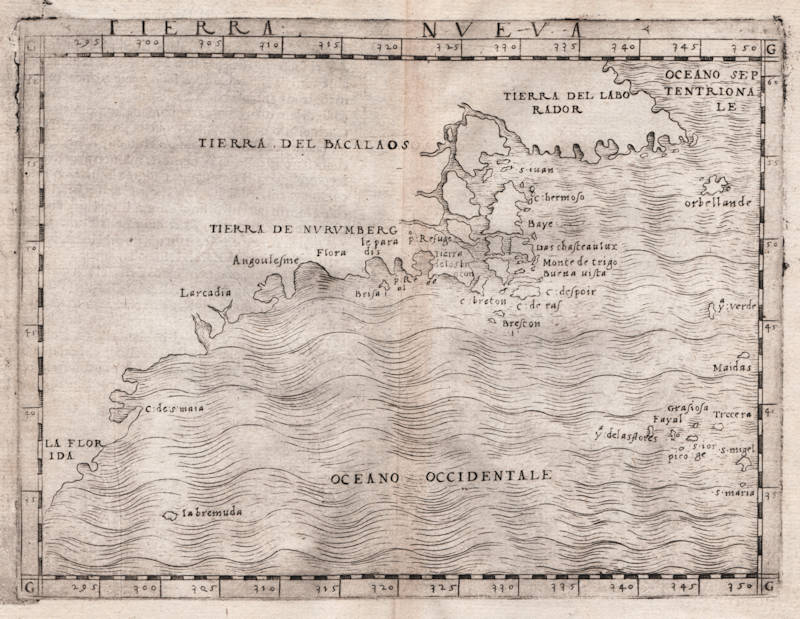
Tierra Nueva
First Published
Venice, 1548
This Edition
1548 first and only edition
Size
13.0 x 17.0 cms
Technique
Condition
mint
Price
This Item is Sold
Description
Giacomo Gastaldi's map of the North American east coast, the first map dedicated to the New England region and the first map to show Bermuda. A cornerstone piece.
It is the first map to concentrate on the North East coastline of North America and the first map to name Bermuda.
"The miniature atlas by Giacomo Gastaldi, of 1548, is of particular interest since it includes the first separate map representations of the US north-east coast; the US south and west and Gulf area; South America; and the islands of Cuba and Santo Domingo."
(Potter p136).
"This map is the first produced of the east coast. It relates the discoveries of the first of Jacques Cartier's voyages to the Gulf of St. Lawrence, and those of Giovanni di Verrazano. The latter was exploring for a passage to Asia on behalf of Francis I, the King of France. This was the first French voyage in the waters of North America. His ship, 'La Dauphine', arrived off the coast of Cape Fear in 1524. After a short venture south he worked his way northwards naming 'Larcadia', 'owing to the beauty of the trees', which Morison identified as present day Kitty Hawk, North Carolina. Over the years cartographers gradually moved this name further north-east until it came to represent the French in the area of Maine and Nova Scotia. Gastaldi noticeably omits the Carolina misconception so vividly shown on Münster's map of 1540. Verrazano then passed by the Chesapeake and Delaware Bays, presumably too far off shore to see them.
Verrazano's most famous discovery was New York Harbour, named by Verrazano 'Angoulesme' after the title of Francis I before he became king. He spent just one day here, 17 april 1524, anchored near the western shore of the narrows. The area of 'Flora'is believed to represent the southern shore of Long Island which he passed before reaching Narragansett Bay, 'p:Refuge', where he remained for two weeks with friendly Indians. Crossing Massachusetts Bay, Verrazano sailed along the Maine coast before working his way back to France, where he arrived in Dieppe in July. Much of New England remained largely unexplored and is here portrayed with some confusion. Of the four regions named only 'TIERRA DE NVRVMBERG' appears for the first time. According to Morison its origins are the Abnaki Indian word for a stretch of water between two falls or rapids. This Verrazano name was later appended to that of a great city. There were no other issues of the map but in 1561 Girolamo Ruscelli emlarged it for his edition of Ptolemy's work."
(Burden 16).
"The voyage of Verrazano (1524), made for Francis I of France in search of a passage to the Orient, had provided a preliminary, partial survey of the eastern seaboard of North America. Although the voyage was the origin of much confusion because of its report of a continental isthmus in the Southeast, it did contribute greatly to the mapping of the coasts far north as Narrangansett Bay. A decade later, France once again send an expedition to find a route around or through North America, this time under the command of Jacques Cartier and bound for the region north of that explored by Verrazano. Cartier, whose previous experience in the New World was limited to commerce with Brazil, explored the Gulf of St. Lawrence on his first voyage to North America (1534), and penetrated the St. Lawrence River as far as Montreal on a second mission (1535). A third voyage is known from Hakluyt's Principal Navigations but no log survives.
Gastaldi has combined data from the Verrazano and Cartier voyages to create this small work, the first printed map devoted to the East Coast of North America. Fusing the two sources created confusion, however. When Verrazano scouted the East Coast of North America, he cautiously headed out to sea after Narragansett Bay to avoid treacherous shoals, but in doing so missed Cape Cod and much of the New England coast. Cartier, on the other hand, did not venture further south than Cape Breton. As a result, Gastaldi grafts eastern Canada onto southern New England, with Cape Breton Island sprouting directly from Narragansett Bay. Mercifully, Gastaldi ignores Verrazano's famous Outer Banks 'isthmus' report and spares the coast the distortion that arose therefrom; unfortunately, though, he does not incorporate data from Cartier's exploration of the St. Lawrence on his second voyage.
Fresh influence from Verrazano is seen in the Northeast, where a new domain makes its debut on a printed map: along with the familiar regions of 'Laborador' and 'Bacalaos' lies 'Tierra de Nurumberg'. (The term originated with the voyage of Verrazano, or at least it first appeared on the portolan made by his brother Girolamo. It appears as 'Oranbega' on the Girolamo Verrazano portolan (manuscript, 1529)). Although Gastaldi's spelling suggests that he associated it with the German city, it was more commonly spelled 'Norumbega' and was probably derived from an Algonquian Indian word which meant something on the order of 'quiet place between two rapids.' The term soon came to denote the region of New England. Further south is New York, calibrated about 5 degrees too far north, and called 'Angoulesme' after Verrazano's designation, 'Angoleme'. The flat shore just up the coast from it, near the name 'Flora', is Long Island but without Long Island Sound. Near 'Larcadia' are two inlets, probably the Chesapeake and Delaware Bays."
(Suárez 25).
"Apparently first visited in 1515 by a Spaniard, Juan de Bermudez, the island's first appearance on an 'available' map is on Gastaldi's 1548 map of the East coast of North America"
(Potter p166 on Bermuda).
Giacomo (Jacopo) Gastaldi (c.1500-1566)
"In Venice in 1548, Giacomo Gastaldi engraved a fine series of maps for what is seen as the first 'pocket' or miniature atlas."
(Potter p38)
"Praised as 'that most excellent of cartographers', Gastaldi was a native of Piedmont and worked in early life as an engineer in the service of the Venetian Republic before turning in the early 1540s to cartography as a profession. Eventually he was appointed Cosmographer to the Republic.
From 1544 onwards he produced a large number of maps beautifully engraved on copper, using a style which was widely copied by his contemporaries, indeed, his technique marked the final transition away from woodblock printing which had been predominant for so long.
Apart from compiling maps of the world and the continents he was responsible for the maps in an edition of Ptolemy issued in 1548 and in a noted collection of voyages and travels called 'Delle Navigazioni e Viaggi' by Giovanni Battista Ramusio (1485-1557). Many of his maps were included in the Lafreri collections of maps in the 1560–80 period.
Gastaldi is credited with popularizing the idea that a route round the north of the American continent led to a passage which he called the Strait of Anian, named after Marco Polo's Kingdom of Anian. The name appeared on many maps well into the seventeenth century."
(Moreland & Bannister p66)
"Jacopo Gastaldi, 'most excellent' of cosmographers, produced a pocket version of Ptolemy in 1548. 'La Geografia di Claudio Ptolemeo' (with 'criticisms and additions' by Sebastian Münster) contained 26 maps from Ptolemy [..], and 34 new maps (some of the New World)."
(Tooley & Bricker)
"Jacopo Gastaldi, born in Piedmont in about 1500, and by the 1540s cosmographer to the Venetian Republic. At least a hundred maps are attributable to Gastaldi, including his 1548 'Geographia' (published by Nicolo Bascarini). It was a popular edition in Italian prose, and expressly designed in quarto, with maps only 5 by 6.75 inches, so that it could be carried 'nella manica' - in the sleeve. (Quarto is the page size that results when a full-sized printed sheet is folded twice instead of a single time that gives a 'folio' page.).
Gastaldi's contemporaries usually described him as the 'most excellent Piedmontese cosmographer'. As a dedicated professional he worked for a number of publishers, accepting occasional private commissions, as when Venice's all-powerful Council of Ten commissioned him to make fresco maps of Asia and Africa for the walls of a room in the Doge's Palace"
(Tooley & Bricker)
"A small but very elegant Italian [Ptolemy] edition with plates, handsomely engraved in copper by the famous cosmographer Gastaldi. [...]. A whole series of plates of the New World is here met with, for the first time, and some of them are of no slight interest to the history of cartography."
(Nordenskjöld 28)
"Sixty maps are engraved in copper in Mattiolo-Gastaldi's Ptolemy of 1548. [...]. On the title-page is written: 'Con alcuni comenti et aggiunti fattevi da Sebastiano Munstero Alamanno, but this evidently refers to the text, not to the maps, which, from a geographical point of view as well as in their technical execution, are immensely superior to those of the learned geographer and Hebrew professor at Basel.
The work is dedicated by Iacobo Gastaldi to Leone Strozzi, 'dignissimo Signore di Capua', whereupon follows an 'A li lettori', where the publisher, Giovanbattista Pedrezano, is highly complimented, for not having spared any expense in getting the maps as finely and well executed as possible, and for having reduced their size as to allow of anybody, without difficulty, carrying the work 'nella manica'. We thus have here the first atlas expressly said to be published in a pocket form."
(Nordenskjöld 40)
"This edition of Ptolemy's 'Geography' was the most comprehensive atlas produced between Martin Waldseemüller's 'Geographia' of 1513, and the Abraham Ortelius 'Theatrum' of 1570. It was the first to contain regional maps of the American continent.
Giacomo Gastaldi had the maps beautifully engraved on copper. This marks a turning point, from now on the majority of cartographic works used this medium. As it was a harder material than wood it gave the engraver the ability to render more detail. Born in Villafranca, Piedmont, Gastaldi became Cosmographer to the Venetian Republic, then a powerhouse of commerce and trade. He sought the most up to date geographical information available, and became one of the greatest cartographers of the sixteenth century."
(Burden 16)


