Leen Helmink Antique Maps & Atlases
www.helmink.com
Bowen
A Complete Map of the Southern ...
Certificate of Authentication
This is to certify that the item illustrated and described below is a genuine antique
map, print or book that was first produced and published in 1744, today 280 years ago.
April 24, 2024
Dr Leendert Helmink, Ph.D.
Cartographer(s)
Bowen
First Published
London, 1744
This edition
1744 first edition
Size
37.4 x 48.2 cms
Technique
Copper engraving
Stock number
18986
Condition
mint
Description
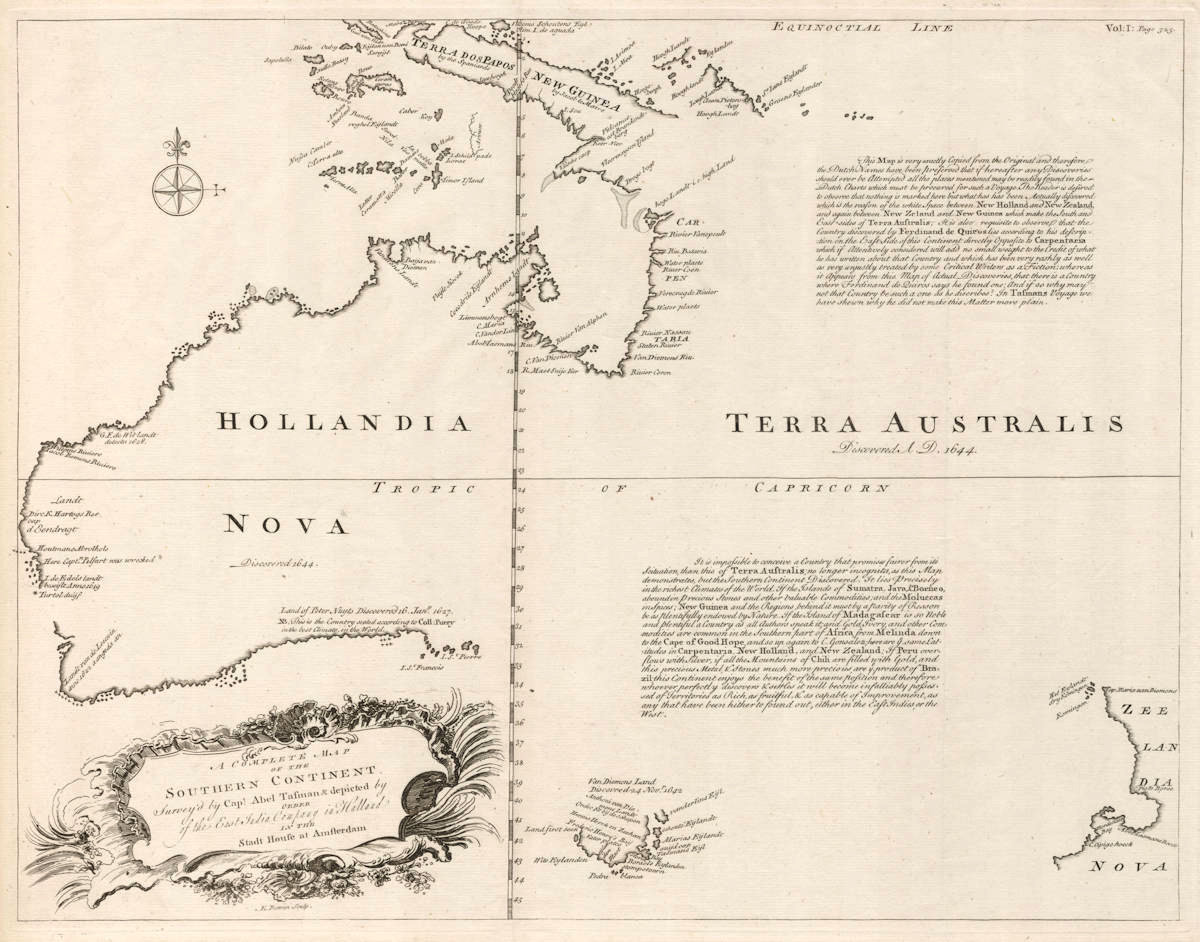
Emanuel Bowen's cornerstone map of Australia. The second large scale map dedicated to the continent (after the Thevenot), and the first one by an Englishman.
"Bowen's important map is the first large-scale map of Australia by an Englishman. It shows both the 1642-43 and 1644 discoveries of Abel Tasman in Australia and New Zealand and is essentially a copy of Thevenot's 1663 map, although some variations exist between the two. Bowen has embellished Thevenot's map by adding two text passages describing the riches that might be discovered in Australia as a result of its geographical location. Bowen also includes a decorative cartouche not found on Thevenot's map."
(Dewez).
"The map by Emanuel Bowen included in the second (1744) edition of John Harris' 'A Complete Collection of Voyages and Travels', prepared by John Campbell, was the first single country map by an Englishman and was closely copied from the Thevenot map. Campbell included narratives by Quiros, Pelsaert, Tasman and Dampier, and in part through an inscription on this map actively encouraged further exploration of the 'southern continent'. "
(Clancy).
Condition
Fine condition. Uncoloured as it should be. Published in the second edition of John Harris’ Navigantium Atque Itinerantium Bibliotheca', London 1744.
Details
BOWEN, Emanuel 1744
A COMPLETE MAP OF THE SOUTHERN CONTINENT Surv'd by Capt. Abel Tasman and depicted by order of the East India Company in Holland in the Stadt House in Amsterdam.
E. Bowen sculp (under cartouche). Vol:1: Page 325 (top r.h.s.). 48.0 x 37.0 cms
First published in the second edition of John Harris' 'Navigantium Atque Itinerantium Bibliotheca', London, 1744
The first large-scale map of Australia by an Englishman showing the 1642-43 and 1644 discoveries of Abel Tasman in Australia and New Zealand.
Despite the fairly rapid and wide dissemination of knowledge concerning the discoveries of Abel Tasman in Australia and New Zealand, information detailing those discoveries is to be found mainly on regional and world maps, rather than maps that show Australia itself.
The first published map detailing only Australia was by Melchissedec Thevenot in 1663. It was the first map focusing on Australia itself to show Tasman's discoveries and a landmark in the charting of that continent.
Bowen’s important map is the first published large-scale English map devoted to Australia and is essentially a copy of Thevenot's 1663 map. Some variations however exist between the two maps. Bowen has embellished Thevenot’s map by adding two text passages describing the riches to be discovered in Australia by virtue of its geographical location. Bowen also includes a decorative cartouche not found on Thevenot's map.
Geographically the maps are identical. Bowen effectively notes all the Dutch discoveries listed on Thevenot's map including those by Tasman from both his first voyage (where Tasmania and New Zealand were charted for the first time) and from his second voyage in north Australia. He includes notes in English such as ‘Land first seen' and 'Van Diemens Land Discovered 24 Nov’r 1642'. Other Dutch discoveries indicated include those by Hartog in Western Australia in 1616 and Houtman in 1619, the van Leeuwin's in 1622, Gerrit de Witt 1628, as well as Pieter Nuyts' 1627 voyage along Australia's south coast. The Cape York Peninsula discoveries by Carstensz in 1623 are also given in detail. New Zealand is labelled “Zeelandia Nova'.
Curiously as with Thevenot's map, a note indicates an incorrect date for the discovery of Australia - Hollandia Nova Discovered 1644'. Harris' books were first published in 1705, however Bowen’s map only appeared in the second and third editions published in 1744 and 1764 respectively.
Bowen was a highly respected cartographer and was hydrographer to Louis XV of France and George II of England.
Tooley 241, pl.12; Clancy illus. pp.136-137; Clancy Terra Australis map 6.25, illus. p.91; Perry / Prescott 1744.01; Perry illus. pp 62-63; NLA Changing Coastlines map 40.
(Dewez).
A legend on Bowen's map emphasised the separation between Hollandia Nova and Terra Australis that had been introduced either inadvertently or intentionally by Thévenot when he placed the two names on either side of the latitude staff running down the 135° East of Greenwich meridian. Bowen's map legend identified Terra Australis as the land described by Quirós in the following text legend:
This Map is very exactly Copied from the Original and therefore the Dutch Names have been preserved that if hereafter any Discoveries should ever be Attempted all the places mentioned may be readily found in the Dutch Charts which must be procured for such a Voyage. The Reader is desired to observe that nothing is marked here but what has has been Actually discovered which is the reason of the white Space between New Holland and New Zealand, and again between New Zeland and New Guinea which make the south and East sides of Terra Australis ; It is also requisite to observe that the Country discovered by Ferdinand de Quiros lies according to his description on the East side of this Continent directly Opposite to Carpentaria which if Attentively considered will add no small weight to the Credit of what he has written about that Country and which has been very rashly as well as very unjustly treated by some Critical Writers as a Fiction; whereas it appears from this Map of Actual Discoveries, that there is a country where Ferdinand de Quiros says he found one: And if so why may not that country be such a one as he discribes? In Tasmans Voyage we have shewn why he did not make this Matter more plain.
Note that the territorial claim made by Britain when the colony of New South Wales was established in 1788 included all of Australia eastward of the meridian of 135° East dividing New Holland from Terra Australis, as shown on Bowen's map. The reason was to minimize a legal dispute with the VOC and the Dutch who had priority over the discovery of Australia, which was the legal golden standard of the day. The Dutch did in fact protest based on legal objections, but the VOC was too weak by that time to make a difference.
Another legend added by Bowen to the map called for discovery and settlement of Terra Australis:
It is impossible to conceive a Country that promises fairer from its Scituation, than this of Terra Australis ; no longer incognita, as this Map demonstrates, but the Southern Continent Discovered. It lies Precisely in the richest Climates of the World. If the Islands of Sumatra, Java, &Borneo, aboundin Precious Stones and other valuable Commodities; and the Moluccas in Spices; New Guinea and the Regions behind it must by a parity of Reason be as plentifully endowed by Nature. If the Island of Madagascar is so Noble and plentiful a Country as all Authors speak it and Gold, Ivory, and other Commodities are common in the Southern part of Africa, from Melinda down to the Cape of Good Hope, and so up again to C. Gonsalez; here are ye same Latitudes in Carpentaria, New Holland, and New Zealand ; If Peru overflows with Silver, if all the Mountains of Chili are filled with Gold, and this precious Metal & Stones much more precious are ye product of Brazil; this Continent enjoys the benefit of the same position and therefore whoever perfectly discovers & settles it will become infalliably possessed of Territories as Rich, as fruitful, & as capable of Improvement, as any that have been hitherto found out, either in the East Indies, or the West.
A small legend on the south coast refers to Jean Pierre Purry, who had been a servant of the Dutch East India Company in Batavia in 1717. He had published a book in Dutch and in English, to propose the settlement Nuyts Land, the present South and South West Australia, which, according to his method to determine this, would have the best climate in the world:
Land of Peter Nuyts Discovered 16. January 1627. NB. This is the Country seated according to Coll:Purry in the best Climate, in the World.
Emanuel Bowen (1694-1767)
Emanuel Bowen, map and print seller, was engraver to George II and to Louis XV of France and worked in London from about 1714 onwards producing some of the best and most attractive maps of the century.
In spite of his royal appointments and apparent prosperity he died in poverty and his son [Thomas], who carried on the business, was no more fortunate and died in a Clerkenwell workhouse in 1790.
(Moreland & Bannister).
Emanuel Bowen (1694 - 8 May 1767) was a Welsh map engraver, who achieved the unique distinction of becoming Royal Mapmaker to both to King George II of Great Britain and Louis XV of France. Bowen was highly regarded by his contemporaries for producing some of the largest, most detailed and most accurate maps of his era. He is known to have worked with most British cartographic figures of the period including John Owen and Herman Moll.
Bowen was born at Tal-y-Llychau (now Talley), Carmarthenshire, Wales. His father was Owen Bowen, a prominent member of the local gentry (i e. "a distinguished but not noble gentleman").
In 1709, Emanuel Bowen was apprenticed as a merchant tailor to Charles Price. Bowen worked in London from 1714 and was admitted to the Merchant Taylors Livery Company on 3 October 1716.
One of his earliest engraved works, Britannia Depicta, published in 1720, contained over two hundred road maps together with a miniature county map of each of the counties of England and Wales. It followed on John Ogilby's earlier work with updated style of historical and heraldic detail. It was an unusual feature of the atlas that the maps were engraved on both sides of each page, resulting in a handier-sized book.
By 1726 he was noted as one of the leading London engravers. Among his multiple apprentices, the most notable were Thomas Kitchin, Thomas Jeffreys, and John Lodge. Another apprentice, John Oakman who had an affair with and eventually married, Bowen's daughter. Other Bowen apprentices include Thomas Buss, John Pryer, Samuel Lyne, William Fowler and his own son Thomas Bowen.
He published "A Complete System of Geography, 1744–7; an 'English Atlas, with a new set of maps,' 1745(?); a 'Complete Atlas ... in sixty-eight Maps,' 1752; 'Atlas Minimus; or a new set of Pocket Maps,' 1758; and a series of separate maps of the English counties, of Germany, Asia Minor, and Persia, between 1736 and 1776.
A recurring feature of Bowen's work, evident even on the early road maps, was his habit of filling every corner and space of the map with jottings and footnotes, both historical and topographical.
In spite of his royal patronage and renown, Bowen like many cartographers of his day, would die in poverty. His son, Thomas Bowen (1733 - 1790) would carry on the business, but would ultimately suffer a similar fate, dying in a Clerkenwell workhouse in 1790.
(Wikipedia)