Leen Helmink Antique Maps & Atlases
www.helmink.com
Linschoten
Exacta & Accurata ... Waarachtige ...
Certificate of Authentication
This is to certify that the item illustrated and described below is a genuine antique
map, print or book that was first produced and published in 1595, today 429 years ago.
April 19, 2024
Dr Leendert Helmink, Ph.D.
Cartographer(s)
Linschoten
First Published
Amsterdam, 1595
This edition
1638
Size
38.0 x 53.0 cms
Technique
Copper engraving
Stock number
18959
Condition
excellent
Description
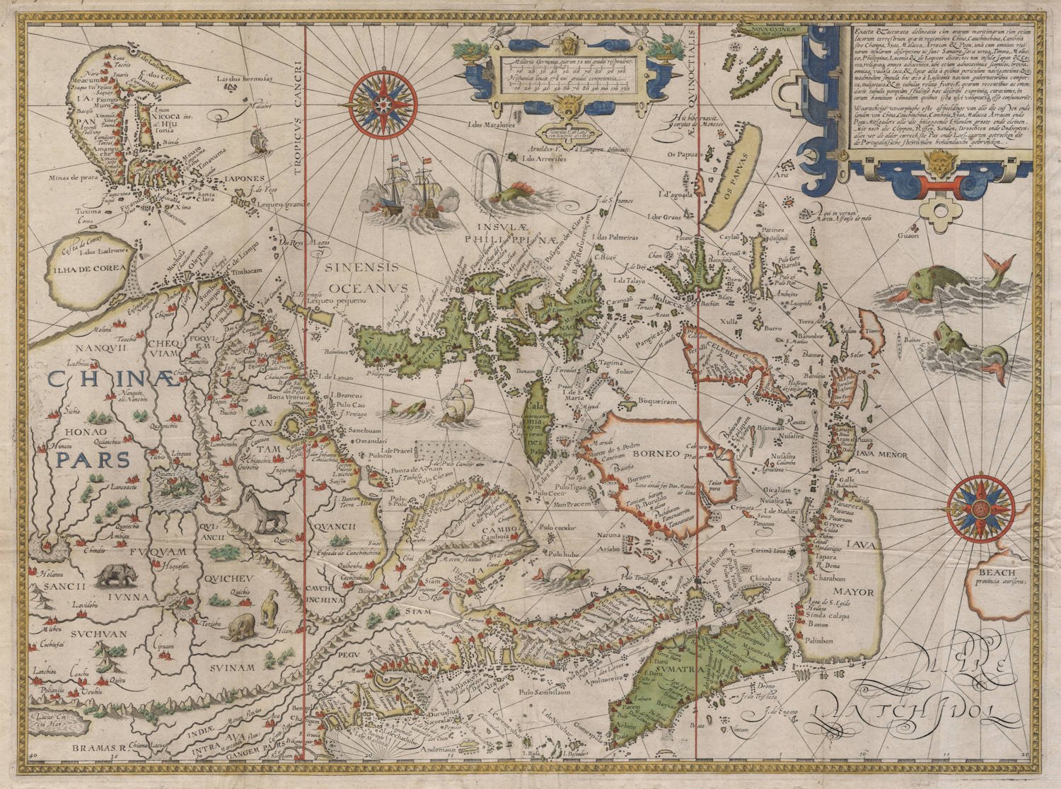
The first accurate map of the Far East. A scarce and very sought after map from Jan Huyghen van Linschoten's legendary Itinerario.
Condition
Dark and even impression of the copperplate. Ample margins all around. Folded as issued. Not cleaned or flattened. No significant paper restorations or imperfections, very authentic look and feel. Gorgeous original colour, which is rare for Linschoten maps. Excellent collector's example of this milestone map.
"Jan Huygen van Linschoten was for five years in the service of the archbishop of Goa whom he accompanied on his journeys in the region of the Indian Ocean.
On the map here the Far East and the Malay Archipelago are shown in such detail as was known only to the Portuguese at that time and had never before been shown on a printed map. The cartographical work of Bartolomeu Lasso served as a model for these charts.
A tiny portion of the south-land can be seen: 'Beach' the auriferous province.
(Schilder).
Map of the Indonesian archipelago and Far East between between 20°S and 40°N
[Latin title] Exacta & accurata delineatio cùm orarum maritimarum tùm etjam | locorum terrestrium qvæ in regionibus China, Cauchinchina, Camboja | sive Champa, Syao, Malacca, Arracan & Pegu, unà cum omnium vici= | narum insularum descriptione ut sunt Sumatra, Java utraq3, Timora, Moluc= | cæ, Philippinæ, Luconja & de Leqveos dictæ; nec non insulæ Japan & Co= | rea, reliquæq; omnes adjacentes, ubi etjam adnotavimus scopulos, brevia, , omniaq3. vadosa loca, & siqvæ alja à qvibus periculum navigantibus: Qve= || madmodum singula hoc ævo à Lusitanis navium gubernatoribus comper= | ta indigetata, & in tabulas relata fvere: E qvorum recentibus ac emen= | datis tabulis perqvàm studiosè hæc describi exprimiqz curavimus; in eorum hominum commodum qvibus ista usvi voluptatiq3 esse consueuerunt.
[Dutch title] Waarachtige wtworpinghe ofte afbeeldinge van alle die custen ende | landen van China, Cauchinchina, Camboja, Sijao, Malacca Arracan ende | Pegu: Mitsgaders alle die bijleggende Eijlanden groote ende cleinen. Mit noch die Clippen, Riffen, Sanden, Droochten ende Ondiepten: | alles wt de alder correckste Pas ende Lees-caarten getrocken die de Portugaloissche stvýrlvijden hvijdendaechs gebrvijcken.
[English translation of title] ‘The true depiction or illustration of all the coasts and lands of China, Cochin China, Cambodia, Siam, Malacca, Arracan and Pegu, likewise of all the adjacent islands, large and small, together with the cliffs, riffs, sands, dry parts and shallows; all taken from the most accurate sea charts and rutters in use by the Portuguese pilots today'.
- Scale:
Miliaria Germanica, quorum 15. uni gradui respondent [100=58 mm);
Hispanicæ leucæ 17½. uni gradui competentia [120=60 mm]
- North at the left
- [Amsterdam: Cornelis Claesz, 1595] / Henricus F. ab Lang | ren sculpsit a°. 1595; Arnoldus F. à Langren delineavit.
- 1 map: copper engraving and etching; 38.5 x 52 cm
Copies:
* Amsterdam, Universiteitsbibliotheek (O.K. 139). This example of the map has never been folded to fit into the Itinerario
* The map comes folded in all 1596-1644 editions of Jan Huygen van Linschoten's Itinerario. According to the binder's instructions, this map could be placed as the buyer prefers (ʻnae ‘t ghelieven vanden cooper'), either in the Itinerario [next to p. 22], or in the Reysgheschrift [next to p. 38].
This map, a continuation of Linschoten's map of the Northen Indian Ocean on the same scale, covers the entire Far East, from Java to Japan. A scale of degrees is provided along the upper and lower edge, indicating latitude at intervals of 5°. A cartouche in the upper right corner contains a bilingual title summarizing the territories depicted here. A cartouche in the middle along the upper edge contains scale bars in Dutch and Spanish miles and below these the name of the engraver with the year and the date of the design. The seas contain drawings of ships and sea monsters as well as two fully drawn compass roses.
This map of 1595 is one of the earliest engraved maps presenting the Portuguese knowledge of this area with such accuracy. The left half of Petrus Plancius's 1592 map of the Moluccas served as the model for the depiction of the Philippines, a large part of the present-day Indonesian archipelago, and the islands lying in between up to the Tropic of Cancer. When composing his map, Plancius made use of manuscript maps by the Portuguese cosmographer and mapmaker Bartolomeu Lasso. Just like the map in the Itinerario, Lasso also shows the entire island of Sumatra and a larger section of the continent from the Bay of Bengal to the coast of China at a latitude of 27°N.
Thus, the map in the Itinerario runs further to the west, but it reaches much less far to the east than Plancius's map. It does not show the numerous island groups in the Pacific Ocean. The hatching on the south coast of Java (IAVA MAYOR) and the east coasts of Borneo and Celebes indicates that these are unknown territories. Bali bears the name Galle, and Sumbawa is called by its old name IAVA MENOR. Halmahera (GILOLO) is shown correctly, though it is too big in relation to the whole. To the southeast of this point, hatching is used to draw an island called OS PAPVAS, which should actually be the beginning of New Guinea. A notable improvement over the older maps is the completion of the mapping of the Philippines. When the Spanish administration was moved from Goa to Manila, the gaps in knowledge about this island archipelago were considerably reduced, and existing information was improved. These advances in knowledge reached Europe through Portuguese maps and found their way into the printed maps, among other sources. Plancius's map and the map in the Itinerario must be counted among the earliest ones to reflect the up-dated information on the Philippines into account.
The map in the Itinerario also includes Korea and Japan in the north. Korea is drawn as a large circular island. The coasts are hatched, indicating that knowledge about this region was still unreliable. Even the correct shape of the northern regions of Japan was still a mystery to people. A very characteristic element shown here is the ebi-shape [= Japanese for shrimp) of Honshu, a drawing that was based on the representations in the cartographic work of the Portuguese mapmaker Fernão Vaz Dourado. Here, Hendrik Floris van Langren engraved a representation of Japan, which had become out of date in the meantime because a new map of Japan was published in the same year, 1595, in the Theatrum Orbis Terrarum. Luis Teixeira made the original drawing available to Abraham Ortelius in 1591 or early in 1592. The map in the Itinerario also shows a larger part of the Chinese interior than shown on Plancius's printed map of the Moluccas. We may assume here that this extension was based on the example of Ortelius's map of China from 1584. That map had been composed with the aid of information from: Jorge de Barbuda, a Portuguese in the service of Philip II of Spain.
In Cornelis Claesz's Const ende Caert-Register (1609), the list of maps available in folio format also includes this map as a loose sheet ['De Moluken van Ian Huyghen']. The map was engraved anew by Robert Beckit in London for the [unauthorized, pirated] English edition of Jan Huygen van Linschoten's Itinerario, which was published by John Wolfe in 1598.
(Schilder)
Jan Huygen van Linschoten (1563-1610)
From:
Itinerario
Voyage ofte Schipvaert van
Jan Huygen van Linschoten
naar Oost ofte Portugaels Indien
Amsterdam, 1596
[with several re-issues up until 1638]
Jan Huyghen van Linschoten, a Dutchman born in Delft, was secretary to the Portuguese Archbishop in Goa between 1583 and 1589. These experiences were recorded in the Itinerario, which was first published in Dutch (Amsterdam: 1595-1596), and contains the most comprehensive account of the East and West Indies available at the end of the sixteenth century. As well as including important travel accounts from contemporary Portuguese, Dutch and Spanish sources, it is the first work to include precise sailing instructions for the Indies and also includes an account of America.
The Itinerario provided detailed practical information on how to get to and carry on the trade with America and India. The work was indispensible to sailors on the route to the Indies; it provided a dictionary of exotic commodities, of national trading methods, etc. Linschoten’s work, along with Hakluyt’s, served as a direct stimulus to the building of the vast English and Dutch overseas empires. Legend has it that copies were given to every ship sailing to India to use as a log-book, as is confirmed in many surviving ship's journals.
Monumenta Cartographica Neerlandica VII - Jan Huygen van Linschoten and his Itinerario
For the publication of Van Linschoten's Itinerario, Cornelis Claesz did not settle for the thirty-six illustrations that had been exquisitely engraved by the Van Doetecum family. The publisher felt he should spare no expense to make the 'heerlijck werck' [masterly piece], as he called it, as accessible as possible to the readership interested in geography. Therefore, he had a number of 'nette, perfecte caerten' [beautiful and perfect maps] made for his own account. Besides a world map, five detail maps were included in the Itinerario and the Beschryvinghe. The world map is the map by Petrus Plancius that had already been engraved in 1594 by Joannes van Doetecum Jr. and published by Cornelis Claesz. But in some copies of the 1596-99 editions of the Itinerario, this map was replaced by another world map. The substitution was arranged in co-operation with the Antwerp publisher Joan Baptista Vrients and the replacement map was engraved by the Van Langren brothers.
The five detailed maps of Van Linschoten's Itinerario, all of which were engraved by Arnold Floris and Hendrik Floris van Langren, cover a large proportion of the non-European world known at the time. According to the map titles, these detail maps were composed with the aid of the best Portuguese and Spanish charts and rutters. These maps clearly reveal the influence of the set of maps that Cornelis Claesz had already published previously (1592-94), for which Petrus Plancius was responsible. Plancius's maps were copied for inclusion into Van Linschoten's work. These copies differ only in minor details from the originals.
(Günter Schilder)
Antique Maps - A Collector's Guide
Van Linschoten, born in Haarlem, is heard of in the service of the Portuguese Archbishop of Goa where he spent five years between 1583 and 1588.
On his return to Holland he produced a History of his travels, important for the inclusion of maps from Portuguese sources, at that time rarely available to Dutch – or any other – cartographers. The maps (including a world map by Petrus Plancius) engraved by van Langren, are highly decorative with large cartouches, the arms of Portugal, compass roses, rhumb lines and sea monsters. Some are illustrated with views of prominent places or islands.
(Moreland and Bannister)