Leen Helmink Antique Maps & Atlases
www.helmink.com
de Wit
Orientaliora Indiarum Orientalium cum Insulis Adjacentibus a Promontorio C. ...
Certificate of Authentication and Description
This is to certify that the item illustrated and described below is a genuine antique
map, print or book that was first produced and published in 1675, today 350 years ago.
July 3, 2025
Cartographer(s)
de Wit
First Published
Amsterdam, 1675
This edition
1675 first edition
Size
43.9 x 54.0 cms
Technique
Copper engraving
Stock number
18951
Condition
excellent
Description
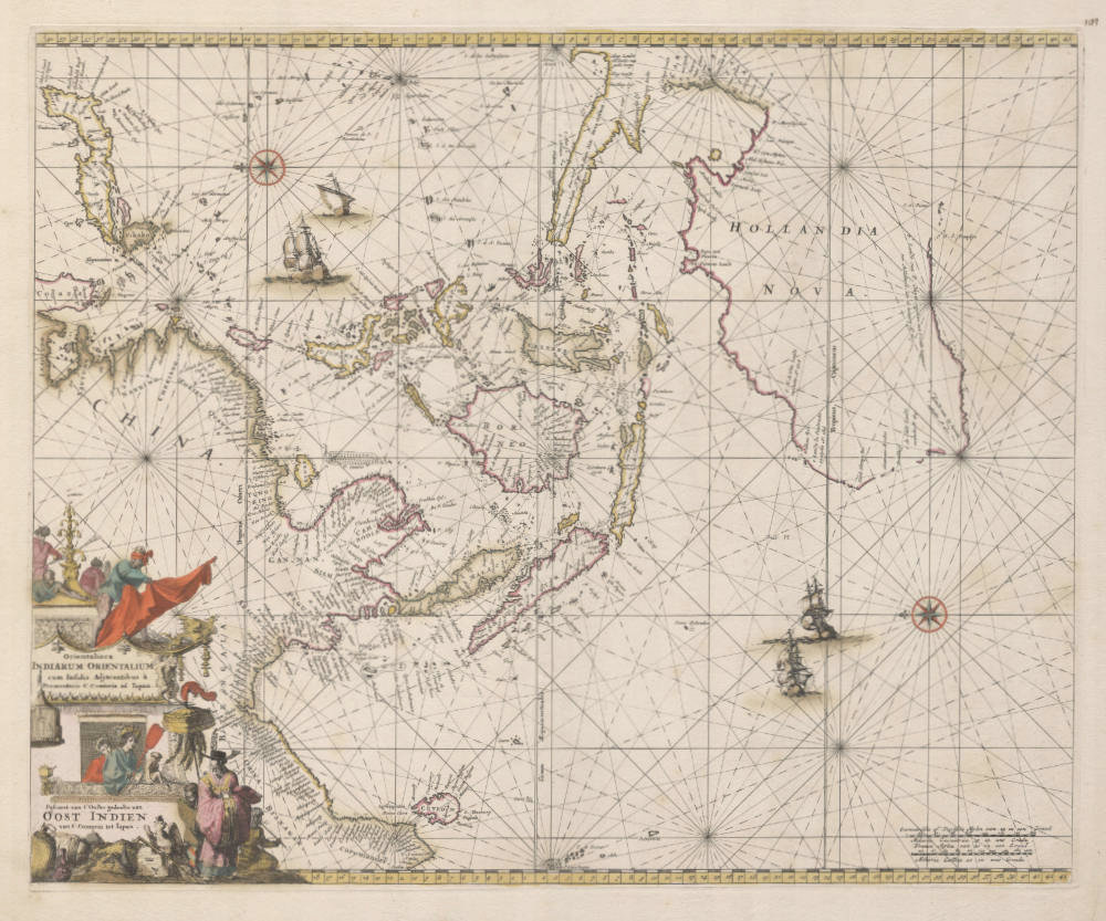
From Frederick de Wit's Sea Atlas Orbis Maritimus ofte Zee Atlas. Classical sea chart of South East Asia and Australia modeled after Pieter Goos' 1666 chart of the area. Tasman's discoveries of the Australian coast are given in detail. East is at the top of the map. A very decorative cartouche showing the people and the products of the far east.
This is the rare Frederick de Wit first edition first state of 1675 of this classic Dutch sea chart.
The chart was re-issued 40 years later in a second state (see example here) by Louis Renard in his Atlas de la Navigation et du Commerce. Amsterdam, 1715. The second state has a plate number "Fol.21." added in the upper right, and when colored it has the typical wash color that was fashionable in the 18th century, instead of the line coloring of the 17th century. A third state (see example here) was re-issued 70 years after the first state, by Reinier and Joshua Ottens, Amsterdam 1745. It has their imprint added ad the bottom of the cartouche, and Tasmania inserted.
Provenance: Ex Collection Geoffrey Allan Edwards (1947-2019)
Condition
Beautiful early line coloring from de Wit's publishing house. First edition, first state. Strong early imprint of the copperplate. Minimal strengthening of the verdigris (copper oxidation of the green colors) in Northern China and the title cartouche. Overall a very attractive example in collector's condition.
This very example of the chart is described and illustrated in Dr David E. Parry's The Cartography of The East Indian Islands - Insulae Indiae Orientalis, a cartobibliograpy of early mapping of South East Asia (page 120).
"The third map of the region produced by Frederick de Wit is a magnificent sea chart entitled Orientaliora Indiarum Orientalium. The chart was originally published in de Wit's maritime atlas Orbis Maritimus ofte Zee Atlas in 1675 and was modelled on a similar chart by Pieter Goos, that was published in De Zee-Atlas ofte Water-Wereld between 1666-83. This chart also served as the prototype for charts of the region by the English mapmaker John Seller and the Amsterdam-based French cartographer Louis Renard. The chart was also published in 1690 in de Wit's maritime atlas Tabulae Maritimae, ofte Zee-Karten, which generally appeared as Volume II of his World Atlas, a collection of 133 maps of the world by de Wit, J. Blaeu, J. Jansson, N. Sanson and others, that was published in the same year.
The chart, which is orientated with east at the top, shows the post-Tasman regional map of Australia and Papua New Guinea, in addition to the Southeast Asian region including the Indonesian and Philippine archipelagoes. The Torres Strait that separates Papua New Guinea from Cape York is still not shown although Torres passed through the straits some seventy-four years before in 1606.
The chart represents the eastern part of a pair of charts with the second chart, entitled Orientaliora Indiarum Indiarum Occidentalium, covering the Indian Ocean from the coast of East Africa and Saudi Arabia, to the west coast of the Indian subcontinent. De Wit's name does not appear anywhere on the eastern chart, but does appear in the cartouche of the western chart."
(Parry).
"This finely engraved map appeared in de Wit's Atlas Maritime, an atlas of sea charts covering the whole world. This is the most detailed chart of the Australian coasts, although the equivalent map of the Pacific includes Tasman's detail to the south."
(Potter).
Frederick de Wit (1629-1706)
Early Life and Beginnings in Amsterdam
Frederick de Wit was born around 1629 in Gouda, a city known for its cultural and intellectual contributions during the Dutch Golden Age. His family was Protestant, and by 1648, 18 or 19 year old De Wit had moved to Amsterdam, a city at the heart of Dutch trade, culture, and mapmaking. Here, he served his apprenticeship under the tutelage of Joan Blaeu, whose family was already famous for producing some of the world's finest atlases and maps.
Establishment in Amsterdam
In 1654, de Wit set up his own printing office and shop, initially named "De Drie Crabben" (The Three Crabs), which was also the name of his residence on Kalverstraat. The following year, he renamed it "De Witte Pascaert" (The White Navigation Chart), signaling his focus on cartography. His early works included a plan of Haarlem in 1648 and illustrations for Antonius Sanderus’s "Flandria Illustrata", but it was his independently engraved map of Denmark in 1659 that marked his entry into the broader mapmaking world.
Cartographic Contributions and Style
De Wit's maps were distinguished by their accuracy, decorative borders, and elaborate cartouches often depicting classical mythology or allegorical scenes. His most famous work, "Nova Totius Terrarum Orbis Tabula," was a world map first published in 1660. The map demonstrated his skill in both geography and artistic design. Over the decades, he produced numerous sea charts, town plans, and wall maps, which were not only navigational aids but also sought after for their beauty and decorative value.
By the 1670s, de Wit was producing larger atlases like the "Atlas Maior" and "Nieuw Kaertboeck van de XVII Nederlandse Provinciën". These atlases combined his own engravings with those he had acquired, showcasing his entrepreneurial spirit. His maps of the Netherlands were particularly notable for their detailed depiction of the Dutch landscape, including cities, waterways, and dykes, reflecting the country's complex relationship with its environment.
Personal Life and Guild Membership
In 1661, de Wit married Maria van der Way, which not only brought him personal happiness but also the privileges of Amsterdam citizenship. This allowed him to join the prestigious Guild of Saint Luke in 1664, which was essential for artists and engravers in the city. His involvement with the guild underscores his standing in the artistic community of Amsterdam.
Later Years and Legacy
De Wit's business thrived, especially after the death of his mentor Blaeu, from which he acquired many copper plates when they were dispersed at auction, positioning him as one of the leading cartographers in Amsterdam. He continued to expand his catalog, ensuring his maps were up-to-date with the latest geographical discoveries. His attention to detail and the aesthetic quality of his work made his maps popular among the elite, scholars, merchants, and navigators alike.
When Frederick de Wit passed away in July 1706, his wife Maria managed the business until 1710. After her death, the vast collection of copper plates was auctioned off, with many going to Pieter Mortier (1661-1711), who used them to further his own publishing empire, Covens & Mortier. In 1721, the copperplates were sold in auction by the heirs of Mortier's widow, and were acquired by the Ottens publishing house in Amsterdam. These transactions illustrate de Wit's lasting influence on the mapmaking industry.
Cultural Impact and Modern Appreciation
De Wit's work encapsulates the spirit of the Dutch Golden Age – a period of unprecedented artistic and scientific achievement. His maps are not merely tools for navigation but are also pieces of art that reflect the cultural pride of the Dutch in their maritime and cartographic prowess. Today, his maps are treasured in collections around the globe, from libraries to smaller, specialized map collections. They are frequently exhibited in museums as exemplars of the Dutch art of cartography, admired for their precision, beauty, and historical significance.
Frederick de Wit's legacy is one of a craftsman whose maps not only charted the physical world but also captured the imagination of those who used them, contributing to the enduring allure of an age when maps were as much about exploration as they were about art.