Leen Helmink Antique Maps & Atlases
www.helmink.com
van Campen
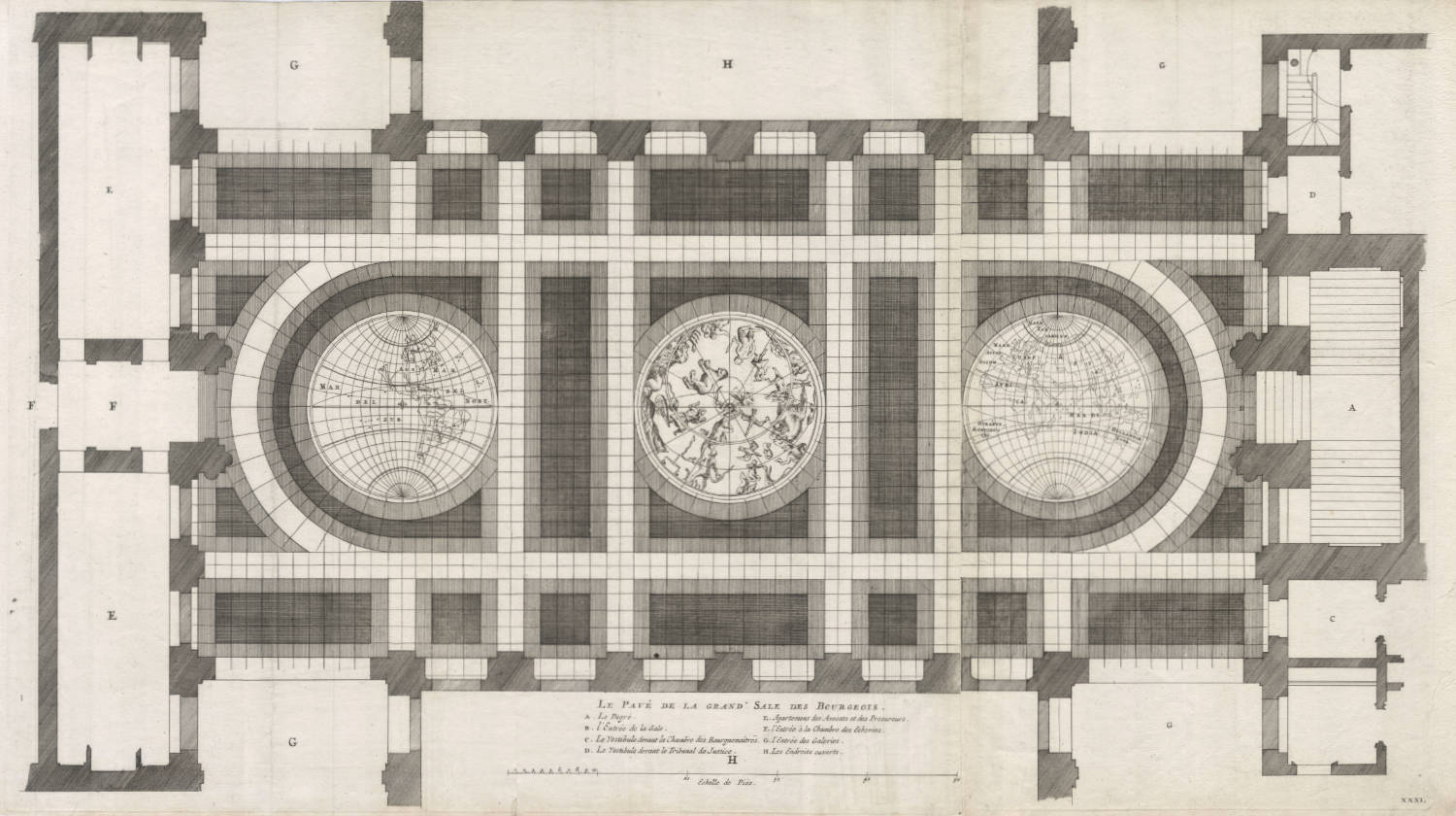
Le Pavé de la Grand Sale des Bourgeois
Certificate of Authentication and Description
This is to certify that the item illustrated and described below is a genuine antique
map, print or book that was first produced and published in 1661, today 364 years ago.
July 5, 2025
Cartographer(s)
van Campen
First Published
Amsterdam, 1661
This edition
1719
Size
44 x 78 cms
Technique
Copper engraving
Stock number
18950
Condition
mint
Description
Anonymous, 1648-1650.
World map in the Burgerzaal of the Amsterdam City Hall
Sketch of the destroyed original
Copper, marble and mosaic cubes
When the grand new city hall of Amsterdam was built in 1648-50, a large world map in marble and copper was laid on the floor of the Burgerzaal. This world included the results of Tasman's voyages and was a symbol in stone of the extension of Dutch seapower in South East Asia. This cartographical work of art was badly damaged by people walking over the floor, so that it had to be restored about a hundred years later. This restoration did not last and the two hemispheres were then filled with plain marble slabs without any pictorial representation. Thus this important cartographical monument was lost to posterity: only the drawing by Jacob Vennekool and the description quoted below recall it.
This drawing is, however, more a sketch than a true copy of the original. New Zealand is not shown, and Van Diemen Land appears, but without a name. In Australia itself which is called HOLLANDIA NOVA account has been taken of Tasman's second voyage.
0lfert Dapper in his work Historische Beschryving der Stadt Amsterdam, Amsterdam 1663, p. 354, gave the following description of this world map:
"Among the other invaluable objects of interest ... one also sees here in the centre, on the floor of the Burgerzaal, two half spheres, bisected at the axis and a celestial hemisphere, of which each has at the centre line or diameter a length of approximately two-and-twenty and in its cirumfence approximately six-and-sixty feet. On the one terrestial hemisphere, towards the east in the Burgerzaal, the contours of the outermost limits of the three parts of the world, to wit Europe, Asia and Africa, as also even the islands, promontaries, rivers and Oceans, and a part of New Holland are shown very ingeniously by red and other coloured inlaid small stone ...."
Source: 'De Grondt en Vloor van de Groote Burger Sael' in Afbeelding van 't Stadthuys van Amsterdam, in dartigh coopere Plaaten, geordineert door Jacob van Campen, en Geteeckent door Jacob Vennekool. Tot Amsterdam ... 1661.
(Schilder).
Condition
Thick paper. Wide margins. Large item, printed on three sheets joined. Strong and even impression of the copperplate. This example in unusually pristine condition. Great collector's example of one of the earliest obtainable items showing the Tasman discoveries of 1632-43 and 1644.