Leen Helmink Antique Maps & Atlases
www.helmink.com
Ortelius
Tartariae Sive Magni Chami Regni typus
Certificate of Authentication and Description
This is to certify that the item illustrated and described below is a genuine antique
map, print or book that was first produced and published in 1570, today 455 years ago.
July 1, 2025
Cartographer(s)
Ortelius
First Published
Antwerp, 1570
This edition
1603 Latin
Size
35.0 x 46.9 cms
Technique
Copper plate engraving
Stock number
18937
Condition
mint
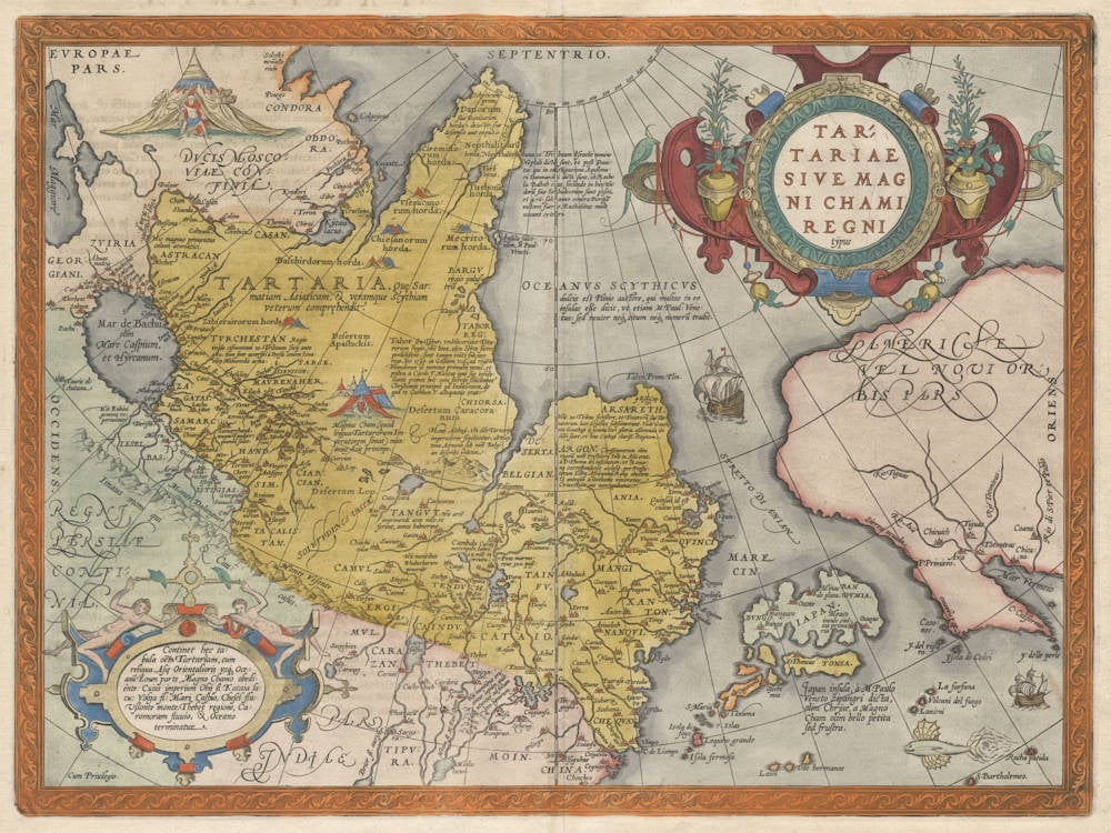
Description
An epic map full of myths and legends, one of the most fascinating early maps of all.
The map offers a detailed view of the almost unknown areas of Tartaria, Cathay (China), Japan (closer to America than to Asia!), and California. The strait of Anian separates Asia and America, and a navigable North-Eastern passage is shown from Europe to Japan and China, complete with sailing ship. China itself is on the map twice, once as Marco Polo's Cathay and once as the newly discovered Empire of China that the Portuguese had reached by sea. Scale ca 1 : 20,000,000.
In California are the seven legendary cities of Cibola (only six are marked), of which the Indians had told the Spanish conquistadores that gold was to be found in abundance, and that the streets and roofs were paved with it.
Many legends are spread around the map, referring to the whereabouts of the lost tribes of Israel (they have to be somewhere!), to Marco Polo, and to the classical geography texts of Strabo, Ptolemy and Pliny. The silk route is shown prominently. No trace of Korea.
The map combines the latest explorations by the Dutch (Vaigatz, Colgoyen), the Portuguese (China, Japan) and the Spanish California) with medieval knowledge (Marco Polo's Cathay, Zipangri, Falcon Island, Tangut, etc.) and with knowledge from classical antiquity (Pliny's Cape Tabin and Scythian Ocean).
"Unlike his map of America, this derives its cartography from Ortelius' own large world map of 1564. This is a very early depiction of the northern Pacific. Its main feature is the 'STRETTO DI ANIAN'. This increased the public awareness of the 1561 Giacomo Gastaldi theory of a strait between the continents of Asia and America. At its southern entrance an enlarged Japan dominates, below which a note states that a large amount of the information in Asia eminates from the writings of Marco Polo. The west coast of North America differs from his map of America in that the peninsula is broader, some different names appear, and others are lacking."
(Burden).
Marcel van den Broecke has transcribed and translated all the legends on the map, as follows (Van den Broecke Ort 163):
Title:
TAR:|TARIAE | SIVE MAG|NI CHAMI | REGNI | "typus".
[Map of Tartaria or the kingdom of the great Cham].
Bottom left corner:
Cum Priuilegio.
[With (copyright) privilege]
Textblocks, from top to bottom, from left to right:
Nepthalitarû | horda Nepthalitæ ab una 10. Tribuum Israelis nomine | Neptali dicti sunt et post Dani:|tas qui in qui in castigatione Aquilona:|ri Danmarchi dicti sunt, ob Rache|lis Balbah ius secundo in loco Hu|dorû sive Iehudeorum sunt positi | et 476 sal anno contra Perosa | victores fuere, Euthalitas male | vocant ceteri.
[The Nephalites are named Neptali after one of the 10 tribes with a Hebrew name, and after the Danites, who by way of punishment were called the Danes of the dark North, and they were on account of the claims of Rachel Balbah placed to the side, in the area of the Hudores or Iehudeores; in the year 476 they were victorious in their battle against Perosa. Others call them incorrectly Euthalites.
Next textblock:
OCEANVS SCYTHICVS| dulcis est Plinio auctore, qui multas in eo | insulas eße dicit, vt etiam M. Paul: Vene:|tus: sed neuter neque situm neque numerû tradit.
[The Scythian ocean, according to Plinius, has sweet water, and he also says it contains many islands, as M. Paulus [Marco Polo] also says, but neither of the two tells about their number or location].
Next texblock:
Tabor seu Tybur vmbilicariaue Tota:|rorum regio, vbi licet olim libros sacros | perdidißent, sunt tamen vniti sub uno | rege, qui 1540. in Galliam vsque ad regem | Franciscum id nominis primum venit, et | postea a Carolo V. Mantuæ ignæ sue infide:|litatis poenas luit: quia secrete solicitabat | Christianos principes ad Iudaismum, de | qua re Carolum V. alloquutus erat.
[Tabor or Tybur, centre of the area of the Tartars, where once the Holy Books got lost, yet they are united under one king, who in 1540 first reached France and king Franciscus, and later, at the initiative of Charles the Fifth was burnt at the stake for his heresy, because he had secretly endeavoured to convert Christian kings to the Jewish religion, about which he had spoken with Charles the Fifth.]
Next textblock:
4 Esd. v.13, ARSARETH. | Hic 10. tribus seceßere et Totatorû siue Tar:|tatorum loco Scythicæ substituerunt. Vnde Gauthæ | seu Gauthay à summa Dei gloria aßerenda ibi | dicti sunt, et hinc Cathay clariß: Regnum.
[4 Ezdra 13; Arsareth. Here the ten tribes retreated, and changed from the Tatar or Tartar area to Scythia. Since then they are called Gauths or Gauthens, confirming Gods highest glory, and here lies the splendid kingdom of Cathai.]
Next textblock:
TVRCHESTAN Regio | vnde cismontani 10. Tribuum socij ante | 900 años sunt accersiti à Persis contra Isma:|elitæ Mahumedis arma.
[Turkestan. The area from which the 10 tribes as allies living on this side of the mountain range have been called 900 years ago by the Persians to fight the armies of Ismael the Muslim.]
Next block:
Magnus Cham, (quod | linga Tartarorum Im:|perator sonat) max:|imus Asiæ princeps.
[The great Khan (which in the language of the Tatars means emperor), the highest ruler of Asia.]
Next block:
ARGON. Christianorum olim | regnû noie Presbiteri Iois in Asia erat, | à D. Thoma ibi institutum, vt Roma:|næ corresponderet ecclesiæ, per Presbi:|terum Ioêm Africanum Romæ obediens | Et antequã a Gothanis vinceretur | Criue Romoue nuncupabantur.
[Argon. Once there was in Asia a Christian kingdom, known to Prester John, and D. Thomas founded it [this city] in this place, so that it was in contact with the church of Rome, and was subjected to Rome through Prester John of Africa. Before it was defeated by the Goths, it was known as Crive Romove.]
Cartouche at left bottom:
Continet hæc ta:|bula oêm Tartariam, cum | reliqua Asiæ Orientalioris usque Oce:|anû Eoum parte, Magno Chamo obedi:|ente: Cuius imperium Obij fl: Kataia la:|cu: Volga fl: Mari Caspio, Chesel flu: | Usonte monte, Thebet regione, Ca:|romoram fluuio, & Oceano | terminatur.
[This map contains the area of Tartaria, with the remaining part of East Asia to the Morning Ocean, subject to the great Khan whose might is bounded by the river Ob, Lake Kataia, the Volga, the Caspian Sea, the river Chesel, the mountains of Usson, the area of Tibet, the river Caromora and the Ocean.]
5 lines in the ocean near Japan:
Japan insula, à M. Paulo | Veneto Zipangri dicta, | olim Chrÿse, a Magno | Cham olim bello petita | sed frustra.
[The isle of Japan, called Zipangri by Marco Polo of Venice, formerly [called] Chr├┐se, once attacked by the great Khan in war, but without success.]
Left top:
Hic magnus prouentus | calami aromatici.
[Here you find great quantities of aromatic reeds.]
Left side middle:
Hic Rubini | gemmæ re:|periuntur.
[Here ruby stones are found.]
Centre:
TANGVT. Hic artê | imprimendi ante mille vt | ferunt, annos habuerunt.
[TANGVT. Here the art of printing was invented thousand years ago, as they say.
Centre:
Mons Althaÿ, vbi oês Tartariæ | imperatores sepeliuntur, ab Haÿ:|tone Armeno sub noîe Belgi:|an describi videtur.
[Mount Althay, where all emperors of Tartaria are buried, seems to have been described by Haithon the Armenian under the name of Belgian.]
Centre left:
TARTARIA, Quæ Sar:|matiam, Asiaticam, & vtramque Scythiam | veterum compræhendit.
[Tartaria which comprises Asian Sarmatia and Outer Scythia of the ancients.]
Top centre:
Schyticum | prom:" | Danorum | "siue Danitarum | horda 1. deiectio siue | descensio aut expulsio.
[Scythian promontory of the Dani or Daniti, a tribe which has disappeared because it has been expelled or has left.]
Centre top:
Insula falco:|num, M Paul: | Veneti.
[The isle of the falcons, according to Marco Polo of Venice.]
Centre:
Cambalu Cataiæ | metropolis, habet | 28.mill: in | circuitu.
[Cambalu, the metropolis of Cathay, is 28 miles in circumference.]
Bottom centre:
His montibus eru:|untur lapides, quib: | utuntur ad focum | loco lignorum.
[From these mountains stones are thrown up which are used as a fire instead of wood.]
Right centre:
Quinsai id est | ciuitas celi.
[Quinsai means community of heaven.]
(Van den Broecke).
Abraham Ortelius (1527-1598)
Abraham Ortelius is the most famous and most collected of all early cartographers. In 1570 he published the first comprehensive collection of maps of all parts of the world, the Theatrum Orbis Terrarum ("Theatre of the World"), the first modern atlas as we know it.
"Abraham Ortel, better known as Ortelius, was born in Antwerp and after studying Greek, Latin and mathematics set up business there with his sister, as a book dealer and ‘painter of maps'. Traveling widely, especially to the great book fairs, his business prospered and he established contacts with the literati in many lands. On one such visit to England, possibly seeking temporary refuge from religious persecution, he met William Camden whom he is said to have encouraged in the production of the Britannia.
A turning point in his career was reached in 1564 with the publication of a World Map in eight sheets of which only one copy is known: other individual maps followed and then – at the suggestion of a friend - he gathered together a collection of maps from contacts among European cartographers and had them engraved in uniform size and issued in 1570 as the Theatrum Orbis Terrarum (Atlas of the Whole World). Although Lafreri and others in Italy had published collections of ‘modern' maps in book form in earlier years, the Theatrum was the first uniformly sized, systematic collection of maps and hence can be called the first atlas, although that term itself was not used until twenty years later by Mercator.
The Theatrum, with most of its maps elegantly engraved by Frans Hogenberg, was an instant success and appeared in numerous editions in different languages including addenda issued from time to time incorporating the latest contemporary knowledge and discoveries. The final edition appeared in 1612. Unlike many of his contemporaries Ortelius noted his sources of information and in the first edition acknowledgement was made to eighty-seven different cartographers.
Apart from the modern maps in his major atlas, Ortelius himself compiled a series of historical maps known as the Parergon Theatri which appeared from 1579 onwards, sometimes as a separate publication and sometimes incorporated in the Theatrum."
(Moreland and Bannister)
"The maker of the ‘first atlas', the Theatrum Orbis Terrarum (1570), started his career as a colorist of maps. Later, he became a seller of books, prints and maps. His scientific and collecting interests developed in harmony with those of a merchant. He was first and foremost a historian. Geography for him was the ‘eye of history', which may explain why, in addition to coins and historical objects, he also collected maps. On the basis of his extensive travels through Europe and with the help of his international circle of friends, Ortelius was able to build a collection of the most up-to-date maps available.
The unique position held by Ortelius's Theatrum in the history of cartography is to be attributed primarily to its qualification as ‘the world's first regularly produced atlas.' Its great commercial success enabled it to make a great contribution to ‘geographical culture' throughout Europe at the end of the sixteenth century. Shape and contents set the standard for later atlases, when the centre of the map trade moved from Antwerp to Amsterdam. The characteristic feature of the Theatrum is that it consists of two elements, text and maps. Another important aspect is that it was the first undertaking of its kind to reduce the best available maps to a uniform format. To that end, maps of various formats and styles had to be generalized just like the modern atlas publisher of today would do. In selecting maps for his compilation, Ortelius was guided by his critical spirit and his encyclopaedic knowledge of maps. But Ortelius did more than the present atlas makers: he mentioned the names of the authors of the original maps and added the names of many other cartographers and geographers to his list. This ‘catalogus auctorum tabularum geographicum,' printed in the Theatrum, is one of the major peculiarities of the atlas. Ortelius and his successors kept his list of map authors up-to-date. In the first edition of 1570 the list included 87 names. In the posthumous edition of 1603, it contained 183 names.
Abraham Ortelius himself drew all his maps in manuscript before passing them to the engravers. In the preface to the Theatrum he stated that all the plates were engraved by Frans Hogenberg, who probably was assisted by Ambrosius and Ferdinand Arsenius (= Aertsen). The first edition of the Theatrum is dated 20 May 1570 and includes 53 maps.
The Theatrum was printed at Ortelius's expense first by Gielis Coppens van Diest, an Antwerp printer who had experience with printing cosmographical works. From 1539 onwards, Van Diest had printed various editions of Apianus's Cosmographia, edited by Gemma Frisius, and in 1552 he printed Honterus's Rudimentorum Cosmograhicorum... Libri IIII. Gielis Coppens van Diest was succeeded as printer of the Theatrum in 1573 by his son Anthonis, who in turn was followed by Gillis van den Rade, who printed the 1575 edition. From 1579 onwards Christoffel Plantin printed the Theatrum, still at Ortelius's own expense. Plantin and later his successors continued printing the work until Ortelius's heirs sold the copperplates and the publication rights in 1601 to Jan Baptist Vrients, who added some new maps. After 1612, the year of Vrients's death, the copperplates passed to the Moretus brothers, the successors of Christoffel Plantin.
The editions of the Theatrum may be subdivided into five groups on the basis of the number of maps. The first group contains 53 maps, 18 maps were added. The second group has 70 maps (one of the 18 new maps replaced a previous one). In 1579 another expansion was issued with 23 maps. Some maps replaced older ones, so as of that date the Theatrum contained 112. In 1590 a fourth addition followed with 22 maps. The editions then had 134 maps. A final, fifth expansion with 17 maps followed in 1595, bringing the total to 151."
(Peter van der Krogt, Atlantes Neerlandici New Edition, Volume III)