Leen Helmink Antique Maps & Atlases
www.helmink.com
Waghenaer and Barentsz
The New Mariners Mirrour
Certificate of Authentication
This is to certify that the item illustrated and described below is a genuine antique
map, print or book that was first produced and published in 1596, today 428 years ago.
April 19, 2024
Dr Leendert Helmink, Ph.D.
Cartographer(s)
Waghenaer and Barentsz
First Published
Amsterdam, 1596
This edition
Amsterdam, 1600
Size
36 x 25 cms
Technique
Copper engraving
Stock number
18929
Condition
excellent
Description
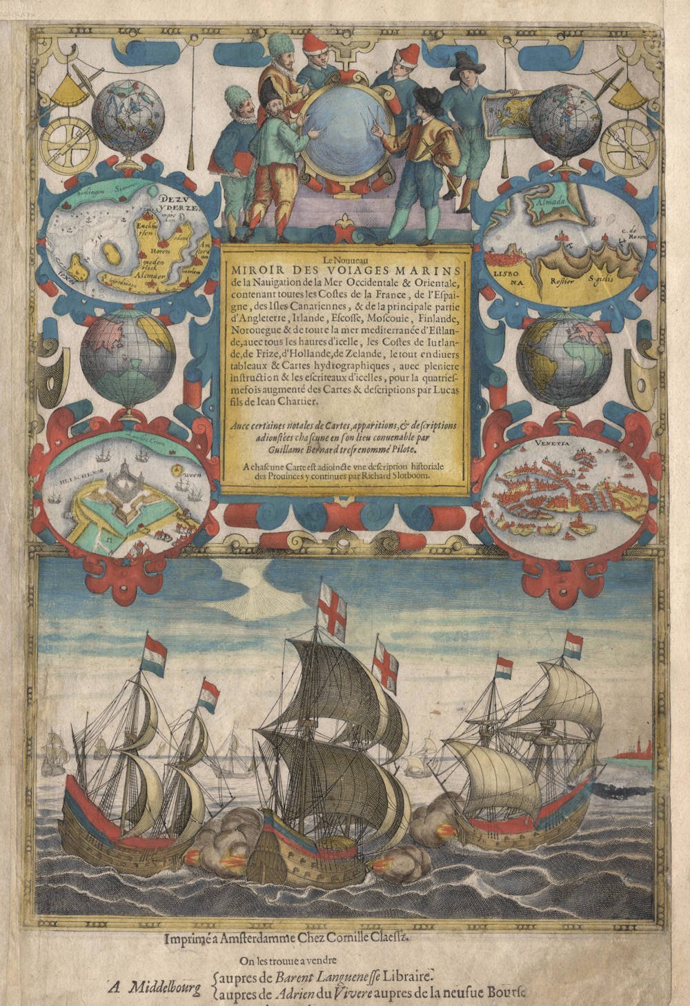
One of the most decorative title page of all times, from the exceptionally rare New Mariner's Mirrour, the greatly expanded re-issue of Waghenaer's maritime atlas. Only a handful examples have survived of this re-issue.
The title text has been printed with letterpress and pasted on, to facilitate different language editions.
The page includes all relevant mariner's navigational instruments of the time, as well as a fierce sea battle between two Dutch and one English man of war. While the Dutch-Anglo relations had been at an all time high with the 1588 joint battle against the Spanish Armada, the friendship had deteriorated in the late 1590s over the fierce competition for the spice trade.
Condition
Top and right margin extended with contemporary paper for convenient framing. Overall an extremely handsome example in old colour and excellent collector's condition.
LUCAS JANSZOON WAGHENAER, 1596 AND WILLEM BARENTSZ, 1595
(Waghenaer, c.1533–1606; Barentsz, 1550–1597)
In 1596 Waghenaer published an expanded version of his chart atlas under the title Den Nieuwen Spieghel der Zeevaert (The New Mirror of Navigation). The publisher, as the imprint at the foot denotes, was Cornelis Claesz. Pictures of mariners' instruments remain, as does the mirror at the top with seamen around it, albeit in different poses. At the foot is now a larger picture of a spirited naval encounter with two Dutch vessels engaging a British ship flying the colors of St Patrick. Centrally, on either side of the printed title, are two global hemispheres and four oval bird's-eye views of ports: Zuiderzee, Helsingor, Lisbon and Venice.
Two of the new charts in Waghenaer's atlas were by Willem Barentsz whose Nieuwe beschryvinghe ende Caertboeck Vande Midlantsche Zee (New description and chartbook of the Mediterranean Sea) had been published only the previous year, 1595.
In 1584 Lucas Janszoon Waghenaer published the first atlas of printed sea charts from Leiden in the Netherlands. It was titled De Spieghel der Zeevaerdt (A Mirror for Sea-farers) and covered the coasts and waters of northern and western Europe. The Spieghel was deemed so important for navigation that the whole work was pirated and translated into English (from the Latin-text edition of 1586) for publication in England in 1588, the year of the Spanish Armada.
As Günter Schilder says in Monumenta Cartographica Neerlandica, Vol VII, Waghenaer's work was a milestone in the development of West European navigation. His charts brought together the pictorial silhouettes that had been a standard feature of traditional rutters used by pilots, and combined these with updated coastal outlines. In addition there were compass roses and lines of navigational direction, as well as soundings to help navigators make their way into ports and havens. Initially the publication was handled by the firm Christopher Plantin with the notable artist Joannes van Doetecum commissioned to engrave the plates. Later, from 1589, the publishing house Cornelis Claesz obtained the publication rights which were cooperatively exercised in conjunction with the firm Jean Bellere from Antwerp.
(Shirley)
In 1600, Cornelis Claesz. and Jean Bellère published the second French edition in a text that was newly typeset. The title explicitly mentions the collaboration of Willem Barentsz: Avec certaines notales de Cartes, apparitions, et descriptions adioustées chascune en son lieu convenable par Guillaume Bernard [Willem Barentsz] tres renommé Pilote. They may have chosen these words to advertise this new edition. The tragic fate of Willem Barentsz, who spent the winter on Novaya Zemlya in 1596/97 and died on the trip home, was still fresh in people's memory.
The last edition by Cornelis Claesz., which appeared in the years 1600-03, was greatly expanded, as the title announces: Den groten dobbelden nieuwe Spiegel der Zeevaert. Long pieces of text and many coastal profiles from Waghenaer's Thresoor der zee-vaert were inserted between the map sheets in this edition. Three new double-sided charts and twelve smaller maps, engraved by Benjamin Wright, were added.
A French edition prepared in 1605 contains the same material. Cornelis Claesz. offered Waghenaer's Spieghel for sale in various combinations. The customers could buy part one and part two of the Spieghel separately for three guilders and six stivers each. For the entire work, they had to pay six guilders and ten stivers. In the end, the expanded version of the last edition cost nine guilders and ten stivers.
Skelton recounts the value of Waghenaer's Spieghel in the following words: 'Waghenaer's Spieghel der Zeevaerdt marks perhaps the greatest single advance in the history of hydrographic publication. Within the covers of a single work it provided the seaman with a manual of practical navigation, a set of printed charts on a common scale, covering the coasts and waters of northern and western Europe, and sailing directions which were otherwise only to be found in rutters unaccompanied by charts. Thus, in the Spieghel, Waghenaer for the first time fused two traditional hydrographic compilations – the sea-atlas and the pilot guide- and presented all the data necessary for coastal navigation in systematic form.
(Schilder)
Lucas Janszoon Waghenaer (c.1534-1598)
By the third quarter of the sixteenth century an ever increasing volume of the wealth of the New World and the Indies was reaching Lisbon and the Spanish porte there to be trans-shipped to Northern and Western Europe. This trade was almost entirely in the hands of the Dutch so it was logical that one of their pilots should produce the first set of effective navigational charts. These were compiled under the title Spiegel der Zeevaerdt, by Lucas Janszoon Waghenaer, a native of Enkhuizen on the Zuider Zee, an experienced seaman and pilot. His magnificently produced charts embodying all the latest contemporary knowledge of navigation and position-finding set a standard which was followed by others for the next century or more – indeed, some of the symbols employed are still in use today.
The charts in the first edition, covering the coast lines from Holland to Spain and the North Sea and Baltic, were engraved by the van Doetecum brothers and printed by Plantin: those in the English edition, which was translated by Sir Anthony Ashley and issued in 1588 – the year of the Armada – were engraved by de Bry, Hondius, Rutlinger and Ryther, who also engraved some of Saxton's maps. The charts are extremely picturesque with elaborate cartouches, ships in full sail and the sea monsters so commonly used as decoration in maps of the period. Place names are given on the coasts but comparatively few are shown inland; cliffs on the coastline are drawn in elevation; navigational landmarks and hazards, anchorages, soundings and tidal details are indicated and the scale is shown in English, Spanish and Dutch leagues. Altogether some of the most handsome maps ever produced.
The charts became so universally popular that their name, anglicized to 'Waggoner', came into use in English as a generic term for sea charts of all kinds.
(Moreland and Bannister)
Willem Barentsz (c.1550-1597)
Willem Barentszoon was a pilot and Arctic explorer who was convinced by the theorists of the day that it was possible to reach and China and the Far East via a North East passage through the Arctic. On his first voyage in 1594 accompanied by Jan Huyghen van Linschoten he reached Novaya Zemlya but was for back by ice: he failed again the following year. On his third voyage in 1596-97 his ship was trapped in pack ice and, although many of his crew survived in open boats, Barentsz himself died on the return voyage.
He is noted for this 1595 chart book of the Mediterranean, the first of its kind, which was complementary to Waghenaer's charts of the Atlantic coasts, and which is sometimes found bound up with the later editions of Waghenaer.
(Moreland and Bannister)