Leen Helmink Antique Maps & Atlases
www.helmink.com
de Bry
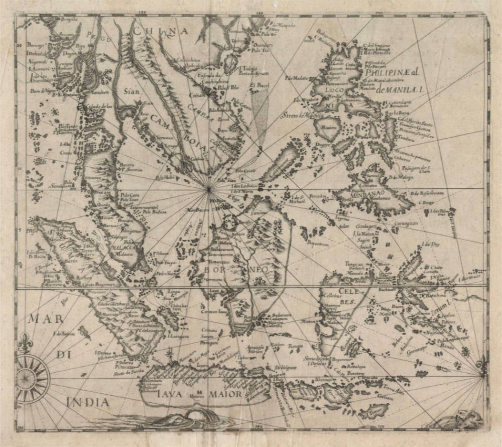
Untitled [Mar di India]
Certificate of Authentication and Description
This is to certify that the item illustrated and described below is a genuine antique
map, print or book that was first produced and published in 1619, today 406 years ago.
July 1, 2025
Cartographer(s)
de Bry
First Published
Frankfurt, 1619
This edition
1619 first and only edition
Size
29.2 x 33.3 cms
Technique
Copper plate engraving
Stock number
18927
Condition
excellent
Description
One of the most treasured maps of Southeast Asia, lacking in all collections.
Theodor de Bry's unobtainable third and final map of South East Asia, published in his exceptionally rare published in both the 1619 German and Latin editions of Part XI ('The Circumnavigations of William Cornelisz Schouten 1615-17 and Joris Van Spilbergen') of the Grands Voyages. These were published more than 20 years after his death by his two sons who expanded the Grand Voyages to voyages in Asia. An exceptionally rare and seminal collector's item.
It is the second time we have seen this map in the market in more than 25 years.
The map is copied from a very rare map from the circumnavigation account of Joris van Spilbergen.
Theodore de Bry repackaged and republished chronicles of contemporary voyages to reach a wider audience than the original accounts had.
MAR DI INDIA
The third map by de Bry of South East Asia is an untitled one of the East Indies and the Philippines that was published in both the 1619 German and Latin editions of Part XI ('The Circumnavigations of William Cornelisz Schouten 1615-17 and Joris Van Spilbergen') of the Grands Voyages. The map has Mar Di India in the lower left corner of the map and copies appeared later in a number of seventeenth- and eighteenth-century travelogues with an inset of the island of Buton in the Celebes in the northeast corner of the map.
The map bears a striking resemblance to Linschoten’s map of 1595 in terms of the shapes and distribution of the East Indian islands but is clearly not a direct copy as there are a number of significant differences, particularly regarding the shape of Java and Sumatra. De Bry's Java is an improvement since it is narrower than Linschoten's, has the island of Madura – which is missing from Linschoten’s map – correctly located and shows the city of Mataram in Central Java for the first time. Sumatra likewise is portrayed more accurately with respect to the shape of the coastline and topographic detail inland.
(Parry)
Rarity
The map is of utmost rarity. It is only the second time in more than 25 years that we see one in the market.
Condition
No restorations or imperfections. Good margins all around. Some folds as issued. Overall a very authentic and handsome example in excellent collector's condition.
Theodore de Bry (c.1527-1598)
De Bry was an engraver, bookseller and publisher, active in Frankfurt-am-Main, who is known to have engraved a number of charts in Waghenaer’s The Mariners Mirrour published in London in 1588. In that same year, also in London, an account was published by Thomas Hariot, illustrated by the artist John White, describing Raleigh's abortive attempt to found a colony in Virginia, and this was to be the inspiration for de Bry's major work, the series of Grands Voyages and Petits Voyages. In all, 54 parts of these two works were issued containing very fine illustrations and beautiful, and now very rare, maps, much sought after by collectors.
(Moreland and Bannister)