Leen Helmink Antique Maps & Atlases
www.helmink.com
de Bry
Nova tabula Insularum Iavae, ...
Certificate of Authentication
This is to certify that the item illustrated and described below is a genuine antique
map, print or book that was first produced and published in 1598, today 426 years ago.
April 27, 2024
Dr Leendert Helmink, Ph.D.
Cartographer(s)
de Bry
First Published
Frankfurt, 1598
This edition
1598
Size
37 x 43 cms
Technique
Copper plate engraving
Stock number
18924
Condition
excellent
Description
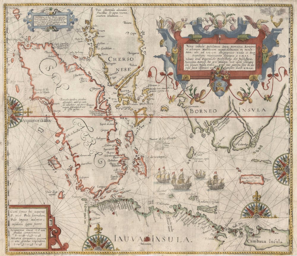
Enter the Dutch. One of the most sought-after maps of the area. From the German edition of Part II of Theodor de Bry's Petit Voyages.
The map is a reduced copy of a chart made by Willem Lodewijcksz who was on the first Dutch fleet to sail to the East Indies under command of Cornelis de Houtman in the years 1595-97. The four ships of the fleet are depicted in the Java Sea.
The Dutch were the first to enter the archipelago through Sunda Strait by crossing the Indian Ocean, instead of the coastal monsoon routes that the Portuguese took. This approach had been recommended by Linschoten, because it was shorter and reduced the risk to run into hostilities with the Portuguese. It was quite a navigation achievement to accurately hit such a small target coming from Madagascar, with only open water and no landmarks in between. Fortunately the volcano of Krakatau (Krakatoa) in Sunda Strait was a 2750 feet tall orientation point at the time (before the 1883 eruption the summit was much higher than after the eruption).
Provenance: Ex Collection Geoffrey Allan Edwards (1947-2019)
Condition
Margins short as always. No restorations or imperfections. Overall a handsome example in excellent collector's condition.
The map is featured on the front cover and on the inside and outside cover of Dr David E. Parry's The Cartography of The East Indian Islands - Insulae Indiae Orientalis, a cartobibliograpy of early mapping of South East Asia.
Southeast Asia, Lodewyckszoon/Theodore de Bry, 1598.
Theodore de Bry repackaged and republished chronicles of contemporary voyages to reach a wider audience than the original accounts had. His adaptation of Willem Lodewijcksz' map is particularly important since the original was banned from the author's own published account, and thus would have otherwise been known only to a small circle of privileged insiders.
(Suárez).
The Lodewijcksz Map of 1598
The dreams and labors of Plancius and Linschoten culminated in Cornelis de Houtman's pioneering voyage to Southeast Asia of 1595-97, which initiated Dutch presence in the Indies. The fleet, heeding Linschoten's advice, entered Indonesian waters by way of the Sunda Strait between Sumatra and Java, rather than the Malacca Strait. De Houtman, in fact, carried on board a copy of Linschoten's Reysgheschrift in manuscript and probably relied heavily on it for sailing directions. Though the financial returns of the voyage were meager, de Houtman nonetheless established commercial relations with the great pepper port of Banten, on the north west coast of Java, near which the Dutch colony of Batavia would soon be founded. The facade of Portuguese invulnerability was quickly eroding; as the great English imperialist Hakluyt observed in 1599, “their strength is nothing so great as heretofore hath been supposed.” The de Houtman expedition gave Holland first-hand data about the Sunda Strait, the northern coast of Java, and the island of Bali.
This first Dutch voyage to the Indies reached home in August of 1597. News of it was related in several works, the first being an anonymous account published by Barent Langenes before the year was out. Most important, however, was the Historie van Indien, published by Cornelis Claesz in April of 1598. Essentially the log of one of the expedition's participants, Willem Lodewijcksz, this book contained profiles of the coasts of the Sunda Strait, a plan of the port of Banten, a plan of the town of Banten, a view of the market at Banten, coastal profiles of Bali and Java, plans of Bali's coast, and a general map of Bali. Several engravings depicted scenes from daily life in Indonesia.
The volume was also supposed to boast a new general map of southern Malaya and the western Indonesian islands; however, in chapter 19 of the volume, we find this note:
Here follows the chart of Java.
But there is no chart. There is the accepted opinion that this mentioned chart was Lodewijcksz's chart. When the merchants saw this chart, the first printed one from this area in such detail, they have forbidden to insert this chart in the log.
The forbidden map, however, was published later the same year as a loose-sheet. It the upper part of the main cartouche, the name Cornelius Nicolai appears, which is the Latinized form of the publisher Claesz, along with that of Baptista van Doetechum, the map's superb engraver. The ‘G.M.A.L.' cited in the attribution is the author, Guilielmus M. A. Lodewijcksz.
As the printed volume noted, this was “the first printed [map] from this area in such detail”. That it was made good use of by pilots is evidenced by the fact that there are two extant examples of the map in which sailing directions for the Java Sea are printed on the verso. But the Amsterdam merchants' concern for keeping the chart confidential proved futile, since before the end of the year a copy of it was published by the German chronicler, Theodore de Bry, in Part II of the Petits Voyages, dealing with the travels of Linschoten. The following year, de Bry published Lodewijcksz's account, together with re-engravings of his views and map of Bali, in Part III of the Petits Voyages.
De Bry’s rendering of the Lodewijcksz map is typical of his beautiful engraving and aesthetic sense. One flaw crept into the copying process, however: de Bry's latitude markings err by one degree compared with the original. Lodewijcksz’ log records that the north coast of Bali lies at 8.5° south latitude, which is very close to the correct figure of 8°. The Claesz /van Doetechum original follows this meticulously, but de Bry's markings are misaligned, mistakenly placing the island's north coast at a latitude of about 7° south.
Larger scale than either the Plancius or Linschoten maps of a few years earlier, the Lodewijcksz map focuses exclusively on southern Malaya, Sumatra, Java, southern Borneo, and the islands east of Java through to Sumbawa — the limited region reconnoitered by de Houtman. The map records unprecedented detail along western and northern Java, and a plethora of small islands in the Sunda Strait itself and on the Indian Ocean threshold to it. Entering the region via the waters between Sumatra and Java rather than by way of Malacca and Singapore, the crew reported so many islands on the western side of the Sunda Strait that they had difficulty finding the channel.
Mataram, a city in the interior of Java, is illustrated in vignette. Though the map is conceived in the style of a mariner's chart, which rarely included interior features, Mataram was relevant to the commercial affairs of European mariners. Most of the northern coast of the island had become dominated by the Muslims by about 1535, the Hindus holding on only at the eastern tip. But Muslim control over the coastal region ebbed in the latter years of the sixteenth century as the interior Muslim states of Mataram and wang became the new nerve centers of Muslim trade, frustrating coastal-based European attempts to control Java. For much of Seventeenth century, Mataram, Banten, and the V.O.C. vied for control of Jaya,
The question of Java's southern coast is evaded by the map. Mapmakers had no available data about the island's southern coast, and traditionally depicted the island as extending much further south than it actually does. Several early sources had set the premise for this. Polo had described it as “the biggest island in the world,” which fact he knew from “the testimony of good seamen who know it well," and early European experience did not contradict this. In fact, as we saw earlier, the reports of Varthema reinforced it.
Before the Dutch reached Java, the mystery of the island's southern coast had been on the minds of Portuguese sailors. The Portuguese questioned their northern Javanese hosts about the southern coast, and were told that few good harbors exist on that coast. The Javanese also explained that the mountains which bisect the island along an east-west axis also stifled communication between the northern and southern shores. Although such indigenous geographical information did not necessarily contribute to the erroneously large idea of the island's width, it did make Portuguese exploration of the southern coast a low priority.
Any Arab sources tapped by the Dutch or Portuguese were likely to concur. The fifteenth-century navigational treatise of Sulaiman al-Mahri stated that
the outer [southern] coast of Java on the west is in a state of ruin and is not inhabited. There is no well-known port there. The ports are all on the east coast [“east” probably equaling ‘north' because of the diagonal orientation implied for the islands in the Arab texts].
Two European sources, however, began to provide clues to the mystery of Java's southern coast. Francis Drake touched on southern Jaya in 1580, providing a reference point about mid-way along the coast. Secondly, the de Houtman expedition itself, sailing west after leaving Bali, set their course for what should have been midway along the eastern coast of Java according to existing charts, and found only open ocean. In the report's words, if the island extended as far south as geographers believed, they would have "sailed through the middle” of it. Thus mapmakers began to narrow the island's latitudinal width and better approximate its southern shores.
The earlier map of Plancius [the "Spice Map"] had depicted the southern region of Sulawesi as segmented from the rest by a narrow neck. Lodewijcksz goes one step further, severing Macasser (Makasser) from the main part of the island and placing it as a separate island to the west, between Borneo and Sumbawa. The city on the east coast of the island, Bogis, is a reference to the Muslim Buginese of south Sulawesi, renowned throughout the region for their seafaring skills.
Bintan, Lingga, Bangka and other islands to the south of the Malay Peninsula, appear in better detail than on earlier maps, while Baixos de los Chineses are marked in the waters between Malay and Borneo, probably referring to low islands frequented by Chinese vessels. The accompanying China bato literally means 'rocks of China' or of the Chinese. East of Bali, old errors still remain: Lombok and Sumbawa are shown as a single island.
(Suárez).
The map is based on Linschoten and derived from an identical map, but with the addition of six vignettes, compiled by Willem Lodewijcksz, a member of Cornelius de Houtman's pioneering voyage to the East Indies in 1595-97. The Lodewijcksz map was supposed to be published in the Histoire van Indien by Cornelis Claesz in 1598 but the detail was such that publication was forbidden by the Dutch merchants; nevertheless, it was published later the same year as a loose-leaf map. The 'G.M.A.L.' cited in the attribution of both maps is the author, Guilielmus M. A. Lodewijcksz.
The maps shows the dangerous southern route to the Spice Islands via the Java Sea, which was threatened by Muslim States hostile to the Portuguese. European traders later chose a safer route north of Borneo through the Sulu Sea. In southern Borneo the Barito River Delta, in the vicinity of present-day Banjarmasin, is very confidently charted to a level of detail and accuracy far exceeding that shown on the maps of Ortelius and de Jode, but the Muar River in southern Malaysia is shown erroneously bisecting the peninsula, a typical feature of late sixteenth and early seventeenth century maps of the region. It is highly probable that the map was also published as a loose-leaf item at the turn of the century.
(Parry).
Theodore de Bry (c.1527-1598)
De Bry was an engraver, bookseller and publisher, active in Frankfurt-am-Main, who is known to have engraved a number of charts in Waghenaer’s The Mariners Mirrour published in London in 1588. In that same year, also in London, an account was published by Thomas Hariot, illustrated by the artist John White, describing Raleigh's abortive attempt to found a colony in Virginia, and this was to be the inspiration for de Bry's major work, the series of Grands Voyages and Petits Voyages. In all, 54 parts of these two works were issued containing very fine illustrations and beautiful, and now very rare, maps, much sought after by collectors.
(Moreland and Bannister)