Leen Helmink Antique Maps & Atlases
www.helmink.com
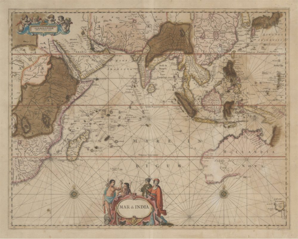
Janssonius
Mar di India
Certificate of Authentication
This is to certify that the item illustrated and described below is a genuine antique
map, print or book that was first produced and published in 1650, today 374 years ago.
April 25, 2024
Dr Leendert Helmink, Ph.D.
Cartographer(s)
Janssonius
First Published
Amsterdam, 1650
This edition
Amsterdam, Jansson Atlas Maior, 1664 or later
Size
43.5 x 55.0 cms
Technique
Copper engraving
Stock number
18916
Condition
Paper toning, oxidation
Description
Map of the Indian Ocean, but in fact covering the whole monopoly charter of the VOC from Cape of Good Hope to Japan.
Here in the exceptionally rare and important second state of this seminal sea chart of the Indian Ocean, updated to include the discoveries of Abel Tasman's voyages of 1642-43 and 1644.
The chart was updated in 1664 for Jansson's Atlas Maior, in a commercially unsuccessful attempt to compete with Joan Blaeu's Atlas Maior. Jansson's Atlas Maior is of greatest rarity. The last example in auction was in the Sotheby's auction in 2005-2006 of the illustrious Lord Wardington collection of atlases.
This edition of the chart is not noted by Koeman or van der Krogt.
We are not aware of any examples offered for sale in dealer catalogues or auctions.
The chart is of seminal importance for the mapping of the fifth continent, and the kind of item that no collection has.
Condition
Paper age toned. Copper oxidation of the green colours.
Johannes Janssonius (1588-1664)
Johannes Janssonius, more commonly known to us as Jan Jansson, was born in Arnhem where his father was a bookseller and publisher (Jan Janszoon the Elder). In 1612 he married the daughter of the cartographer and publisher Jodocus Hondius, and then set up in business in Amsterdam as a book publisher. In 1616 he published his first maps of France and Italy and from then onwards he produced a very large number of maps, perhaps not quite rivalling those of the Blaeu family but running a very close second in quantity and quality. From about 1630 to 1638 he was in partnership with his brother-in-law, Henricus Hondius, issuing further editions of the Mercator/Hondius atlases to which his name was added. On the death of Henricus he took over the business, expanding the atlas still further, until eventually he published an 11-volume "Atlas Major" on a scale similar to Blaeu's "Atlas Maior".
The first full edition of Jansson’s English County Maps was published in 1646 but some years earlier he issued a number of British maps in the Mercator/Hondius/ Jansson series of atlases (1636–44); the maps were printed from newly engraved plates and are different from the later 1646 issue and are now rarely seen. In general appearance Jansson’s maps are very similar to those of Blaeu and, in fact, were often copied from them, but they tend to be more flamboyant and, some think, more decorative.
After Jansson's death his heirs published a number of maps in an "Atlas Contractus" in 1666 and later still many of the plates of his British maps were acquired by Pieter Schenk and Gerard Valck, who published them again in 1683 as separate maps.
(Moreland and Bannister)