Leen Helmink Antique Maps & Atlases
www.helmink.com
Jodocus Hondius I
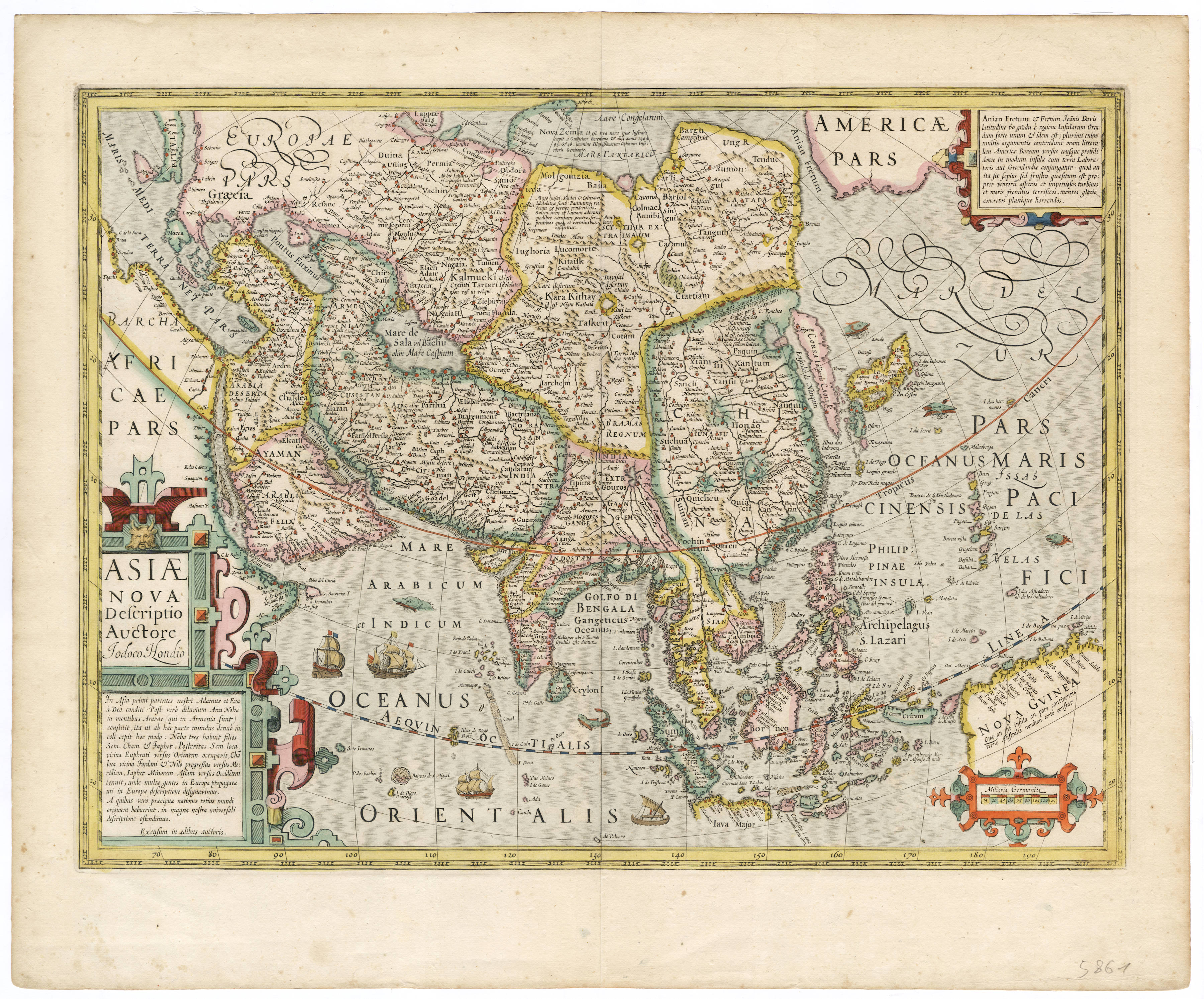
Asiae nova Descriptio Auctore Jodoco Hondio
Certificate of Authentication and Description
This is to certify that the item illustrated and described below is a genuine antique
map, print or book that was first produced and published in 1606, today 419 years ago.
July 3, 2025
Cartographer(s)
Jodocus Hondius I
First Published
Amsterdam, 1606
This edition
1623 Latin
Size
37.0 x 50.0 cms
Technique
Copper engraving
Stock number
18914
Condition
excellent
Description
Overview map of Asia by Jodocus Hondius the Elder, the foremost engraver and mapmaker of his day.
From 1606 through 1630, this map of Asia was published alongside the map of Asia of Gerard Mercator, whose maps he re-issued after acquiring the copperplates in 1604.
The map is the most accurate of the day, incorporating the knowledge of the Portuguese with the latest discoveries of the Dutch fleets who had overrun the Indonesian archipelago.
A scalebar conveniently covers the area south of New Guinea, because it was not known if that was an island or part of the Unknown Southland. Interestingly, when this map was published in 1606, skipper Willem Jansz and his yacht Duyfken were exploring exactly those waters and would be the first Europeans to discover Australia.
Condition
Lovely minimal age-toning. Some minor spotting. Very wide margins. Dark and even imprint of the copperplate. Collector's condition.
Jodocus Hondius (1563-1612)
Jodocus Hondius the Younger (son) (1594-1629)
Henricus Hondius (son) (1597-1651)
Jodocus Hondius the Elder, one of the most notable engravers of his time, is known for his work in association with many of the cartographers and publishers prominent at the end of the sixteenth and the beginning of the seventeenth century.
A native of Flanders, he grew up in Ghent, apprenticed as an instrument and globe maker and map engraver. In 1584, to escape the religious troubles sweeping the Low Countries at that time, he fled to London where he spent some years before finally settling in Amsterdam about 1593. In the London period he came into contact with the leading scientists and geographers of the day and engraved maps in The Mariner's Mirrour, the English edition of Waghenaer's Sea Atlas, as well as others with Pieter van den Keere, his brother-in-law. No doubt his temporary exile in London stood him in good stead, earning him an international reputation, for it could have been no accident that Speed chose Hondius to engrave the plates for the maps in The Theatre of the Empire of Great Britaine in the years between 1605 and 1610.
In 1604 Hondius bought the plates of Mercator's Atlas which, in spite of its excellence, had not competed successfully with the continuing demand for the Ortelius Theatrum Orbis Terrarum. To meet this competition Hondius added about 40 maps to Mercator's original number and from 1606 published enlarged editions in many languages, still under Mercator's name but with his own name as publisher. These atlases have become known as the Mercator/ Hondius series. The following year the maps were re-engraved in miniature form and issued as a pocket Atlas Minor.
After the death of Jodocus Hondius the Elder in 1612, work on the two atlases, folio and miniature, was carried on by his widow and sons, Jodocus II and Henricus, and eventually in conjunction with Jan Jansson in Amsterdam. In all, from 1606 onwards, nearly 50 editions with increasing numbers of maps with texts in the main European languages were printed.
(Moreland and Bannister)